Geomorphology
Type of resources
Keywords
Publication year
Service types
Topics
-
A high-resolution multibeam echosounder (MBES) dataset covering over 279,000 km2 was acquired in the southeastern Indian Ocean to assist the search for Malaysia Airlines Flight 370 (MH370) that disappeared on 8 March 2014. The data provided an essential geospatial framework for the search and is the first large-scale coverage of MBES data in this region. Here we report on geomorphic analyses of the new MBES data, including a comparison with the Global Seafloor Geomorphic Features Map (GSFM) that is based on coarser resolution satellite altimetry data, and the insights the new data provide into geological processes that have formed and are currently shaping this remote deepsea area. Our comparison between the new MBES bathymetric model and the latest global topographic/bathymetric model (SRTM15_plus) reveals that 62% of the satellite-derived data points for the study area are comparable with MBES measurements within the estimated vertical uncertainty of the SRTM15_plus model (± 100 m). However, > 38% of the SRTM15_plus depth estimates disagree with the MBES data by > 100 m, in places by up to 1900 m. The new MBES data show that abyssal plains and basins in the study area are significantly more rugged than their representation in the GSFM, with a 20% increase in the extent of hills and mountains. The new model also reveals four times more seamounts than presented in the GSFM, suggesting more of these features than previously estimated for the broader region. This is important considering the ecological significance of high-relief structures on the seabed, such as hosting high levels of biodiversity. Analyses of the new data also enabled sea knolls, fans, valleys, canyons, troughs, and holes to be identified, doubling the number of discrete features mapped. Importantly, mapping the study area using MBES data improves our understanding of the geological evolution of the region and reveals a range of modern sedimentary processes. For example, a large series of ridges extending over approximately 20% of the mapped area, in places capped by sea knolls, highlight the preserved seafloor spreading fabric and provide valuable insights into Southeast Indian Ridge seafloor spreading processes, especially volcanism. Rifting is also recorded along the Broken Ridge – Diamantina Escarpment, with rift blocks and well-bedded sedimentary bedrock outcrops discernible down to 2400 m water depth. Modern ocean floor sedimentary processes are documented by sediment mass transport features, especially along the northern margin of Broken Ridge, and in pockmarks (the finest-scale features mapped), which are numerous south of Diamantina Trench and appear to record gas and/or fluid discharge from underlying marine sediments. The new MBES data highlight the complexity of the search area and serve to demonstrate how little we know about the vast areas of the ocean that have not been mapped with MBES. The availability of high-resolution and accurate maps of the ocean floor can clearly provide new insights into the Earth's geological evolution, modern ocean floor processes, and the location of sites that are likely to have relatively high biodiversity. <b>Citation:</b> Kim Picard, Brendan P. Brooke, Peter T. Harris, Paulus J.W. Siwabessy, Millard F. Coffin, Maggie Tran, Michele Spinoccia, Jonathan Weales, Miles Macmillan-Lawler, Jonah Sullivan, Malaysia Airlines flight MH370 search data reveal geomorphology and seafloor processes in the remote southeast Indian Ocean, <i>Marine Geology</i>, Volume 395, 2018, Pages 301-319, ISSN 0025-3227, https://doi.org/10.1016/j.margeo.2017.10.014.
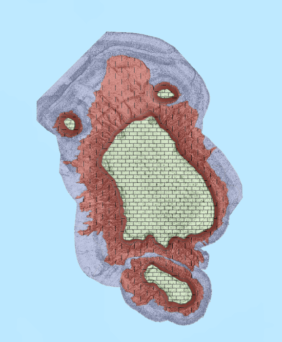
-
This report presents key results from the Upper Burdekin Groundwater Project conducted as part of Exploring for the Future (EFTF)—an eight year Australian Government funded geoscience data and information acquisition program. The first four years of the Program (2016–20) aimed to better understand the potential mineral, energy and groundwater resources in northern Australia. The Upper Burdekin Groundwater Project focused on the McBride Basalt Province (MBP) and Nulla Basalt Province (NBP) in the Upper Burdekin region of North Queensland. It was undertaken as a collaborative study between Geoscience Australia and the Queensland Government. This document reports the key findings of the project, as a synthesis of the hydrogeological investigation project and includes maps and figures to display the results.
-
<div>This data product contains geospatial seabed morphology and geomorphology information for the Beagle Marine Park and is intended for use by marine park managers, regulators, the general public and other stakeholders. A nationally consistent two-part (two-step) seabed geomorphology classification system was used to map and classify the distribution of key seabed features. </div><div><br></div><div>In step 1, semi-automated GIS mapping tools (GA-SaMMT; Huang et al., 2022; eCat Record 146832) were applied to bathymetry digital elevation models (DEM) in a GIS environment (ESRI ArcGIS Pro) to map polygon extents (topographic high, low, and planar) and quantitatively characterise their geometries. The geometric attributes were then used to classify each shape into discrete Morphology Feature types (Part 1: Dove et al., 2020; eCat Record 144305). In step 2, the seabed geomorphology was interpreted by applying additional datasets and domain knowledge to inform their geomorphic characterisation (Part 2: Nanson et al., 2023; eCat Record 147818). Where available, backscatter intensity, seabed imagery, seabed sediment samples and sub-bottom profiles supplemented the bathymetry DEM and morphology classifications to inform the geomorphic interpretations.</div><div><br></div><div>The Beagle Marine Park seabed morphology and geomorphology features were informed by a post survey report (Barrett et al., 2021). Seabed units were classified at multiple resolutions that were informed by the underlying bathymetry: </div><div><br></div><div>· A broad scale layer represents features that were derived from a 30 m horizontal resolution compilation DEM (Beaman et al 2022; eCat Record 147043). </div><div>· A series of medium and fine scale feature layers were derived from individual 1 m horizontal resolution DEMs (Nichol et al., 2019; eCat Record 130301). </div><div><br></div><div>The data product and application schema are fully described in the accompanying Data Product Specification. </div><div><br></div><div><em>Barrett, N, Monk, J., Nichol, S., Falster, G., Carroll, A., Siwabessy, J., Deane, A., Nanson, R., Picard, K., Dando, N., Hulls, J., and Evans, H. (2021). Beagle Marine Park Post Survey Report: South-east Marine Parks Network. Report to the National Environmental Science Program, Marine Biodiversity Hub. University of Tasmania.</em></div><div><br></div><div><em>Beaman, R.J. (2022). High-resolution depth model for the Bass Strait -30 m. <a href=https://dx.doi.org/10.26186/147043>https://dx.doi.org/10.26186/147043</a>, GA eCat Record 147043. </em></div><div><br></div><div><em>Dove, D., Nanson, R., Bjarnadóttir, L. R., Guinan, J., Gafeira, J., Post, A., Dolan, Margaret F.J., Stewart, H., Arosio, R., Scott, G. (2020). A two-part seabed geomorphology classification scheme (v.2); Part 1: morphology features glossary. Zenodo. <a href=https://doi.org/10.5281/zenodo.40752483>https://doi.org/10.5281/zenodo.4075248</a>; GA eCat Record 144305 </em></div><div><br></div><div><em>Huang, Z., Nanson, R. and Nichol, S. (2022). Geoscience Australia's Semi-automated Morphological Mapping Tools (GA-SaMMT) for Seabed Characterisation. Geoscience Australia, Canberra. <a href=https://dx.doi.org/10.26186/146832>https://dx.doi.org/10.26186/146832</a>; GA eCat Record 146832 </em></div><div><em> </em></div><div><em>Nanson, R., Arosio, R., Gafeira, J., McNeil, M., Dove, D., Bjarnadóttir, L., Dolan, M., Guinan, J., Post, A., Webb, J., Nichol, S. (2023). A two-part seabed geomorphology classification scheme; Part 2: Geomorphology classification framework and glossary (Version 1.0) (1.0). Zenodo.<a href=https://doi.org/10.5281/zenodo.7804019>https://doi.org/10.5281/zenodo.7804019</a>; GA eCat Record 147818 </em></div>
-
<div>This data product contains geospatial seabed morphology and geomorphology information for Flinders Reefs and Cairns Seamount (Coral Sea Marine Park). These maps are intended for use by marine park managers, regulators, the general public and other stakeholders. A nationally consistent two-part (two-step) seabed geomorphology classification system was used to map and classify the distribution of key seabed features. </div><div><br></div><div>In step 1, semi-automated GIS mapping tools (GA-SaMMT; Huang et al., 2022; eCat Record 146832) were applied to a bathymetry digital elevation model (DEM) in a GIS environment (ESRI ArcGIS Pro) to map polygon extents (topographic high, low, and planar) and to quantitatively characterise their geometries. Their geometric attributes were then used to classify each shape into discrete Morphology Feature types (Part 1: Dove et al., 2020; eCat Record 144305). In step 2, the seabed geomorphology was interpreted by applying additional datasets and domain knowledge to inform their geomorphic characterisation (Part 2: Nanson et al., 2023; eCat Record 147818). Where available, backscatter intensity, seabed imagery, seabed sediment samples and sub-bottom profiles supplemented the bathymetry DEM and morphology classifications to inform the geomorphic interpretations.</div><div><br></div><div>The Flinders Reefs seabed morphology and geomorphology maps were derived from an 8 m horizontal resolution bathymetry DEM compiled from multibeam surveys (FK200429/GA4861: Beaman et al., 2020; FK200802/GA0365: Brooke et al, 2020), Laser Airborne Depth Sounder (LADS), Light Detection and Ranging (LiDAR) and bathymetry supplied by the Australian Hydrographic Office.</div><div><br></div><div>A subset of the FK200802/GA0365 multibeam survey was gridded at 1 m horizontal resolution to derive the key morphology and geomorphology features at the top of Cairns Seamount (-35 to -66 m; within the upper mesophotic zone).</div><div><br></div><div>The data product and application schema are fully described in the accompanying Data Product Specification. </div><div><br></div><div><em>Beaman, R., Duncan, P., Smith, D., Rais, K., Siwabessy, P.J.W., Spinoccia, M. 2020. Visioning the Coral Sea Marine Park bathymetry survey (FK200429/GA4861). Geoscience Australia, Canberra. <a href=https://dx.doi.org/10.26186/140048>https://dx.doi.org/10.26186/140048</a>; GA eCat record 140048</em></div><div><br></div><div><em>Brooke, B., Nichol, S., Beaman, R. 2020. Seamounts, Canyons and Reefs of the Coral Sea bathymetry survey (FK200802/GA0365). Geoscience Australia, Canberra. <a href=https://dx.doi.org/10.26186/144385>https://dx.doi.org/10.26186/144385</a>; GA eCat record 144385</em></div><div><br></div><div><em>Dove, D., Nanson, R., Bjarnadóttir, L. R., Guinan, J., Gafeira, J., Post, A., Dolan, Margaret F.J., Stewart, H., Arosio, R., Scott, G. (2020). A two-part seabed geomorphology classification scheme (v.2); Part 1: morphology features glossary. Zenodo. <a href=https://doi.org/10.5281/zenodo.4075248>https://doi.org/10.5281/zenodo.4075248</a>; GA eCat Record 144305 </em></div><div><br></div><div><em>Huang, Z., Nanson, R. and Nichol, S. (2022). Geoscience Australia's Semi-automated Morphological Mapping Tools (GA-SaMMT) for Seabed Characterisation. Geoscience Australia, Canberra. <a href=https://dx.doi.org/10.26186/146832>https://dx.doi.org/10.26186/146832</a>; GA eCat Record 146832</em></div><div><br></div><div><em>Nanson, R., Arosio, R., Gafeira, J., McNeil, M., Dove, D., Bjarnadóttir, L., Dolan, M., Guinan, J., Post, A., Webb, J., Nichol, S. (2023). A two-part seabed geomorphology classification scheme; Part 2: Geomorphology classification framework and glossary (Version 1.0) (1.0). Zenodo. <a href=https://doi.org/10.5281/zenodo.7804019>https://doi.org/10.5281/zenodo.7804019</a>; GA eCat Record 147818 </em></div>
-
<div>Maps of seabed geomorphology derived from bathymetry data provide foundational information that is used to support the sustainable use of the marine environment across a range of activities that contribute to the Blue Economy. The global recognition of the value of the Blue Economy and several key global initiatives, notably the Seabed 2030 project to map the global ocean and the United Nations Decade of Ocean Science for Sustainable Development, are driving the proliferation and open dissemination of these data and derived map products. To effectively support these global efforts, geomorphic characterisation of the seabed requires standardized multi-scalar and interjurisdictional approaches that can be applied locally, regionally and internationally. This document describes and illustrates a geomorphic lexicon for the full range of coastal to deep ocean geomorphic Settings and related Processes that drive the formation, modification and preservation of geomorphic units on the seabed. Terms and Settings/Processes have been selected from the literature and structured to balance established terminology with the need for consistency between the range of geomorphic Settings. This document also presents a glossary of the terms and identifies the insights that can be gained by mapping each unit type, from an applied perspective.</div> <b>Citation:</b> Nanson, Rachel, Arosio, Riccardo, Gafeira, Joana, McNeil, Mardi, Dove, Dayton, Bjarnadóttir, Lilja, Dolan, Margaret, Guinan, Janine, Post, Alix, Webb, John, & Nichol, Scott. (2023). <i>A two-part seabed geomorphology classification scheme; Part 2: Geomorphology classification framework and glossary (Version 1.0) (1.0).</i> Zenodo. https://doi.org/10.5281/zenodo.7804019
-
The service contains the Australian Coastal Geomorphology Smartline, used to support a national coastal risk assessment. The 'Smartline' is a representation of the geomorphic features located within 500m of the shoreline, denoted by the high water mark. The service includes geomorphology themes and stability classes.
-
This data product contains seabed morphology and geomorphology information for a subset area of Zeehan Marine Park. A nationally consistent seabed geomorphology classification scheme was used to map and classify the distribution of key seabed features. The Zeehan Marine Park seabed morphology and geomorphology maps were derived from a 2 m horizontal resolution bathymetry DEM compiled from a multibeam survey undertaken for Parks Australia by the University of Tasmania. Semi-automated GIS mapping tools (GA-SaMMT); (Huang et. al., 2022; eCat Record 146832) were applied to a bathymetry digital elevation model (DEM) in a GIS environment (ESRI ArcGIS Pro) to map polygon extents (topographic high, low, and planar) and to quantitatively characterise polygon geometries. Geometric attributes were then used to classify each shape into discrete Morphology Feature types (Dove et. al., 2020; eCat Record 144305). Seabed geomorphology features were interpreted by applying additional datasets and domain knowledge to inform their geomorphic characterisation (Nanson et. al., 2023; eCat Record 147818). Where available, backscatter intensity, seabed imagery, and survey reports supplemented the bathymetry DEM and morphology classifications to inform the geomorphic interpretations. The data product and classification schema are fully described in the accompanying Data Product Specification. Dove, D., Nanson, R., Bjarnadóttir, L. R., Guinan, J., Gafeira, J., Post, A., Dolan, Margaret F.J., Stewart, H., Arosio, R., Scott, G. (2020). A two-part seabed geomorphology classification scheme (v.2); Part 1: morphology features glossary. Zenodo. https://doi.org/10.5281/zenodo.4075248; Huang, Z., Nanson, R., Nichol, S. 2022. Geoscience Australia's Semi-automated Morphological Mapping Tools (GA-SaMMT) for Seabed Characterisation. Geoscience Australia, Canberra. https://dx.doi.org/10.26186/146832 Nanson, R., Arosio, R., Gafeira, J., McNeil, M., Dove, D., Bjarnadóttir, L., Dolan, M., Guinan, J., Post, A., Webb, J., Nichol, S. (2023). A two-part seabed geomorphology classification scheme; Part 2: Geomorphology classification framework and glossary (Version 1.0) (1.0). Zenodo. https://doi.org/10.5281/zenodo.7804019
-
<div>A groundwater chemistry, regolith chemistry and metadata record for legacy geochemical studies over the southern Curnamona Province done by GA and partners as part of CRC LEME from 1999 to 2005, that was never fully released. This includes comprehensive groundwater chemistry from more than 250 bores in the Broken Hill region, containing physicochemical parameters, major and trace elements, and a suite of isotopes (34S, Pb, Sr, 18O, D). Recent work on this dataset (in 2021) has added hydrostratigraphic information for these groundwater samples. Also included is a regolith geochemistry dataset collected adjacent to some of the groundwater bores which tests the geochemical response of a range of different size fractions, depths and digests.</div>
-
Abstract: The extent to which fluids may leak from sedimentary basins to the seabed is a critical issue for assessing the potential of a basin for carbon capture and storage. The Petrel Sub-basin, located beneath central and eastern Joseph Bonaparte Gulf in tropical northern Australia, is identified as potentially suitable for the geological storage of CO2 because of its geological characteristics and proximity to offshore gas and petroleum resources. In May 2012, a multidisciplinary marine survey was undertaken to collect data in two targeted areas of the Petrel Sub-basin to facilitate an assessment of CO2 storage potential. Multibeam bathymetry and backscatter mapping (650 km2 over 5,300 line km), combined with acoustic sub-bottom profiling (650 line km) and geomorphological and sediment characterisation of the seabed was undertaken above the CO2 supercritical seal boundary of the sub-basin. Features identified in the high resolution (2 m) bathymetry data include carbonate banks, ridges, pockmark fields and fields of low amplitude hummocks located directly adjacent to banks. Unit and composite pockmarks and clusters of pockmarks are present on plains and adjacent to, and on, carbonate ridges. It is postulated that there are three possible sources for fluids and fluidised gas involved in pockmark formation: deep fluids from the basin, post-Cretaceous intra-formational, layer-bound fluids, and shallow-sourced fluidised gas from the breakdown of organic matter following the Holocene marine transgression of Joseph Bonaparte Gulf.
-
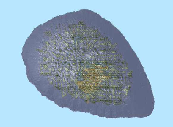
This ESRI map (web) service contains geospatial seabed morphology and geomorphology information for Cairns Seamount within the Coral Sea Marine Park and are intended for use by marine park managers, regulators, the general public and other stakeholders. This web service uses the data product published in McNeil et al. (2023); eCat Record 147998.