Spatial
Type of resources
Keywords
Publication year
Service types
Topics
-
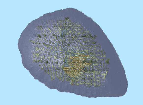
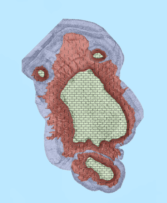
Abstract: Spatial predictions of seabed sediments based on samples in the Australian Marine Samples (MARS) database provide environmental baseline information used in the management of Australia’s marine jurisdiction, offshore resource development, and marine protected areas. The MARS database holds 14204 samples, distributed unevenly across the Australian Exclusive Economic Zone (AEEZ). As such, interpolations of seabed samples are often required for understanding target regions between collection sites. Data quality in the MARS database also varies, with data quality control resulting in the exclusion of over 7,000 samples, most of which were dredged samples. Dredged samples are thought to lower the accuracy of the spatial predictions produced from the database. In this study we examined whether these excluded dredged samples should for spatial predictions by assessing whether the dredged samples decreased or increased the accuracy of the resulting spatial predictions of seabed mud content, and whether the dredging method used altered the accuracy of the resulting prediction. We confined our analyses to two contrasting areas in the AEEZ: the Southwest Region (407 total samples; 150 dredged) and Petrel Region (534 total samples; 297 dredged). We compared the accuracy of interpolated surfaces of mud content generated from QC’d samples with surfaces generated with samples from different dredge types (benthic, pipe, chain bag and unspecified). In the Southwest region samples included 73 benthic, 19 pipe, 41 chain bag, and 17 unspecified dredged samples. In the Petrel region samples included 46 pipe and 251 unspecified dredged samples. Spatial predictions of seabed mud content were made using Inverse Distance Weighting (IDW) and Ordinary Kriging (OK). Predictive errors were assessed based on leave-one-out cross-validation in terms of relative mean absolute error (RMAE). The effects of dredged samples on the predictive error were analysed using paired Mann-Whitney tests. For sediment samples in the Southwest region, including benthic dredge samples in the prediction reduced the accuracy of IDW by 1.79% in terms of RMAE. Including chain bag dredge samples increased the accuracy of IDW with a small difference in RMAE of 0.47%. The difference in accuracy of IDW was insignificant for the unspecified type samples, all dredged sample types and pipe dredged samples. Including samples with all-dredged type and unspecified type dredge samples improved the accuracy of the OK predictions over the QCed samples in the Southwest region with a small effect on RMAE of 0.68% for all-dredged samples and 0.65% for unspecified type dredged samples. The difference in accuracy of OK was insignificant for benthic dredged, pipe dredged and chain bag dredged samples in the Southwest region. No significant effects on the accuracy of IDW in the Petrel region were found for all the tested dredged sample types (unspecified type, pipe dredged samples, and all-dredged samples). The difference in accuracy of OK in the Petrel Region for samples with all dredged and with unspecified dredged samples was insignificant. Including pipe dredged samples increased the accuracy of OK in the Petrel with a negligible effect on RMAE of 0.02%. In summary, the inclusion of dredged samples produced minimal effects on the accuracy of spatial predictive models. Effects were not consistent across region or dredge type, but findings showed dredged samples had surprisingly little effect on the accuracy of the predictions Including the dredged samples would require reprocessing the spatial predictions for the AEEZ based on the MARS database, so as the findings are only based mud sediment data from two regions caution should be taken to generalise these findings to other sediment types and to the entire Australian marine margin. Further testing is required to verify these findings for other regions and sediment types and identify whether future spatial predictions can include some of this extra data without a loss in accuracy. This paper was submitted/presented at the 22nd International Congress on Modelling and Simulation (MODSIM2017) conference, 3-8 December 2017
-
This OGC Web Feature Service (WFS) contains geospatial seabed morphology and geomorphology information for Cairns Seamount within the Coral Sea Marine Park and are intended for use by marine park managers, regulators, the general public and other stakeholders. This web service uses the data product published in McNeil et al. (2023); eCat Record 147998.
-
This OGC Web Feature Service (WFS) contains geospatial seabed morphology and geomorphology information for the Beagle Marine Park (South-east Marine Parks Network) and is intended for use by marine park managers, regulators and other stakeholders. This web service uses the data product published in Nanson et al. (2023); eCat Record 147976.
-
This OGC Web Feature Service (WFS) contains seabed morphology and geomorphology information for a subset area of Zeehan Marine Park (South-east Marine Parks Network) and is intended for use by marine park managers, regulators and other stakeholders. This web service uses the data product published in McNeil et al. (2023); eCat Record 148620.
-
This OGC Web Map Service (WMS) contains seabed morphology and geomorphology information for a subset area of Zeehan Marine Park (South-east Marine Parks Network) and is intended for use by marine park managers, regulators and other stakeholders. This web service uses the data product published in McNeil et al. (2023); eCat Record 148620.
-
This ESRI map (web) service contains geospatial seabed morphology and geomorphology information for Cairns Seamount within the Coral Sea Marine Park and are intended for use by marine park managers, regulators, the general public and other stakeholders. This web service uses the data product published in McNeil et al. (2023); eCat Record 147998.
-
This ESRI map (web) service contains geospatial seabed morphology and geomorphology information for the Beagle Marine Park (South-east Marine Parks Network) and is intended for use by marine park managers, regulators and other stakeholders. This web service uses the data product published in Nanson et al. (2023); eCat Record 147976.
-
This ESRI map (web) service contains geospatial seabed morphology and geomorphology information for Flinders Reefs within the Coral Sea Marine Park and are intended for use by marine park managers, regulators, the general public and other stakeholders. This web service uses the data product published in McNeil et al. (2023); eCat Record 147998.
-
The SDE Built Environment Database (SBUILTENV) is a subset of the former SDE Best Available Geographic Database (SBAGD). SBUILTENV contains only the built environment feature datasets and feature classes such as Culture, Habitation and Infrastructure. There has been limited updates to the data since 2013. SBAGD is a historic database comprising the GEODATA TOPO 250K Series 3 data and any updates that were made from 2008-2013. This vector data represents major topographic features and has been sourced through many programs such as the National Topographic Information Coordination Initiative (NTICI). The topographic data complies with the Topographic Data and Map Specifications for the National Topographic Database & NTMS Series 1:250 000 & 1:100 000 scale topographic map products version 6.0. To use this dataset please contact the Spatial Platforms team (eGIS), spatialplatforms@ga.gov.au, and obtain an SDE login for use within your selected GIS software.
-
The Foundation Rail Infrastructure feature dataset is part of the Foundation Spatial Data Framework theme for Transport. The Foundation Rail Infrastructure feature dataset is specifically made up of Rail line features (Railways, Rail Sidings and Tramline including Light Rail) and Rail points (Stations). This feature class represents a national aggregation of the spatial locations and attributes of line and point features, of publicly available data. Rail Infrastructure information has been derived from various sources provided by data custodians including Spatial Services (NSW), Department of Natural Resources, Mines and Energy (QLD), Department of Environment, Land, Water and Planning (VIC), Land Tasmania (TAS) and Department of Infrastructure and Transport (SA). The coverage is across all states and territories however due to restrictive licensing, Geoscience Australia data was used as the source data for Western Australia (lines and points), the Northern Territory (lines and points) and South Australia (points). Data published by Victoria falling within South Australia has been included (points). Further information on datasets provided by State and Territory custodians can be found under Source Information in the metadata statement.