Minerals
Type of resources
Keywords
Publication year
Service types
Topics
-
The Exploring for the Future Project Areas web service depicts the spatial extents of project work undertaken as part of Geoscience Australia's $100.5 million initiative dedicated to boosting investment in resource exploration in Australia. Each project area extent has been generated by aggregating all project work sites into an envelope polygon. An indicative spend on each f the projects is also given.
-

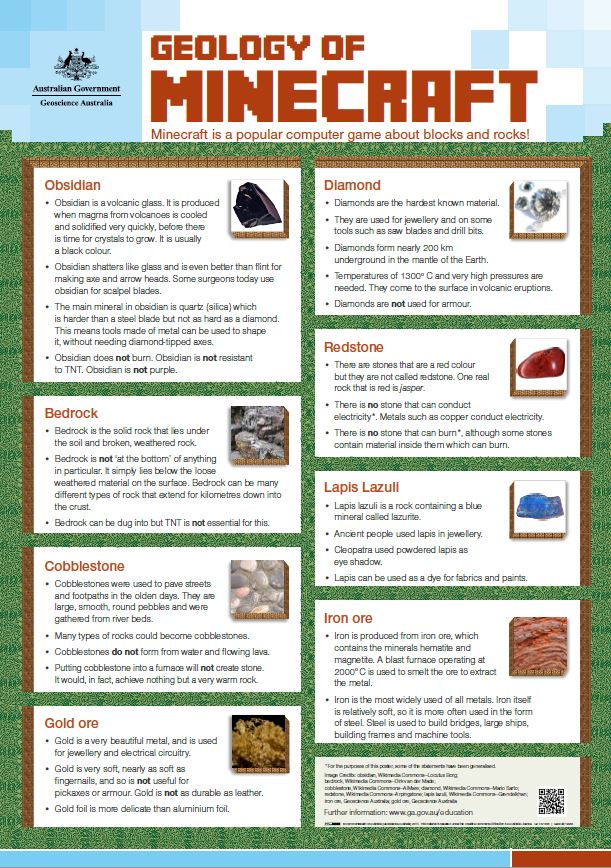
A second colour poster comparing the concepts in the computer game Minecraft with particular minerals and rocks. Aimed at school children, for display in classrooms. Designed to be printed at A2, but can also be printed smaller.
-
This mineral collection comprises 13,000+ locality based museum quality specimens derived from BMR/AGSO/GA field survey programs, from external organisations (e.g. Australian Museums, state geological surveys), or from donations or bequests by private collectors. It includes specimens from all over the world with a strong emphasis on minerals from Broken Hill.
-
<div>Australia's Identified Mineral Resources is an annual national assessment that takes a long-term view of Australian mineral resources likely to be available for mining. The assessment also includes evaluations of long-term trends in mineral resources, world rankings, summaries of significant exploration results and brief reviews of mining industry developments.</div>
-
Exploring for the Future was a $100.5 million initiative by the Australian Government dedicated to boosting investment in resource exploration in Australia. The four-year program (2016-2020) focused on northern Australia and parts of South Australia. The under-explored northern Australian region offers enormous potential for industry development and is advantageously located close to major global markets. Geoscience Australia's leading scientists used and developed new innovative techniques to gather new scientific data and information, on an unprecedented scale, about the potential mineral, energy and groundwater resources concealed beneath the surface. This work was undertaken in greenfield areas, where the Exploring for the Future program had the greatest impact. This dataset depicts the geographical extents of the various projects undertaken as part of this program, with an indicative total spend for each
-
Statements of existing knowledge are compiled for known mineral, coal, hydrocarbon and carbon capture and storage (CCS) resources and reserves in the Cooper Basin. This data guide illustrates the current understanding of the distribution of these key resource types within the Cooper Basin region based on trusted information sources. It provides important contextual information on the Cooper Basin and where additional details on discovered resources can be found. To date, mineral or coal deposits have not been found in the Cooper Basin, due to its depth. There are significant hydrocarbon resources found in the basin, including conventional and unconventional hydrocarbons. The Cooper Basin has been a major producer of oil and gas since the 1960s (Smith, Cassel and Evans, 2015). It is one of the largest sources of onshore hydrocarbon production in Australia. Some of the largest unconventional gas resources are contained in the basin. This is mostly basin-centred gas. The geology in the Cooper Basin is considered suitable for use in Carbon Capture and Storage (CCS) projects. The Cooper Basin and overlying Eromanga Basin contain 2 CCS projects that are currently being developed.
-
Australia - Offshore Minerals Act 1994 - Mineral Blocks - epoch 2014a. This service displays the Australian Mineral Blocks - Aligned with the current Australian Maritime Boundary Dataset. Refer to the metadata of the geodatabase for a detailed abstract relating to the data.
-
A colour poster comparing the concepts in the computer game Minecraft with the geology of particular minerals and rocks. Aimed at school children, for display in classrooms. Designed to be printed at A2, but can also be printed smaller.
-
Following the successful outcomes of the Tennant Creek-Mt Isa (TISA) mineral potential assessment (Murr et al., 2019; Skirrow et al., 2019), the methodology has been expanded to encompass the entire North Australian Craton (NAC). Like its predecessor, this assessment uses a knowledge-based, data-rich mineral systems approach to predict the potential for iron oxide-copper-gold (IOCG) mineralisation. With their high metal yield and large alteration footprint, IOCG mineral systems remain an attractive target in directing exploration efforts towards undercover regions. This mineral potential assessment uses a 2D GIS-based workflow to map four key mineral system components: (1) Sources of metals, fluids and ligands, (2) Energy to drive fluid flow, (3) Fluid flow pathways and architecture, and (4) Deposition mechanisms, such as redox or chemical gradients. For each of these key mineral system components, theoretical criteria representing important ore-forming processes were identified and translated into mappable proxies using a wide range of input datasets. Each of these criterion are weighted and combined using an established workflow to produce a models of IOCG potential. Metadata and selection rational are documented in the accompanying NAC IOCG Assessment Criteria Table. Two scenarios were modelled for this assessment. The first is a comprehensive assessment, targeting pre-Neoproterozoic mineral systems (>1500 Ma), using a combination of interpreted, geological and geophysical datasets. As geological interpretations are subjective to the geological knowledge of the interpreter, well-documented areas, such as shallow pre-Neoproterozoic basement, have a greater density of data. This increase in data density can create an inherent bias in the modelled result towards previously explored shallow terrains. The second assessment utilises only datasets which can be mapped consistently across the assessment area. As such, these are predominately based on geophysical data and are more consistent in assessing exposed and covered areas. However, far fewer criteria are included in this assessment, and observations are reflective of only the modern geological environment. Both assessments highlight existing mineral fields in WA, NT and QLD, and suggest that these regions extend under cover. Furthermore, regions not previously known for IOCG mineralisation display a high modelled potential, offering exploration prospects in previously unknown or discounted areas.
-
<div><strong>Yathong, Forbes, Dubbo, and Coonabarabran Airborne Electromagnetic Survey Blocks.</strong></div><div><br></div><div>Geoscience Australia (GA), in collaboration with the Geological Survey of New South Wales (GNSW), conducted an airborne electromagnetic (AEM) survey from April to June 2023. The survey spanned from the north-eastern end of the Yathong-Ivanhoe Trough and extended across the Forbes, Dubbo, and Coonabarabran regions of New South Wales. A total of 15, 090-line kilometres of new AEM and magnetic geophysical data were acquired. This survey was entirely funded by GSNSW and GA managed acquisition, quality control, processing, modelling, and inversion of the AEM data.</div><div><br></div><div>The survey was flown by Xcalibur Aviation (Australia) Pty Ltd using a 6.25 Hz HELITEM® AEM system. The survey blocks were flown at 2500-metre nominal line spacings, with variations down to 100 metres in the Coonabarabran block. It was flown following East-West line directions. Xcalibur also processed the acquired data. This data package includes the acquisition and processing report, the final processed AEM data, and the results of the contractor's conductivity-depth estimates. The data package also contains the results and derived products from a 1D inversion by Geoscience Australia with its own inversion software.</div><div><br></div><div>The survey will be incorporated and become part of the national AusAEM airborne electromagnetic acquisition program, which aims to provide geophysical information to support investigations of the regional geology and groundwater.</div><div><br></div><div><strong>The data release package contains:</strong></div><div><br></div><div>1. A data release package <strong>summary PDF document</strong></div><div>2. The <strong>survey logistics and processing report</strong> and HELITEM® system specification files</div><div>3. <strong>Final processed point located line data</strong> in ASEG-GDF2 format for the five areas</div><div> -final processed dB/dt electromagnetic, magnetic and elevation data</div><div> -final processed B field electromagnetic, magnetic and elevation data</div><div><strong> <em>Conductivity estimates generated by Xcalibur’s inversion </em></strong></div><div> -point located conductivity-depth line data output from the inversion in ASEG-GDF2 format</div><div> -graphical (PDF) multiplot conductivity stacks and section profiles for each flight line</div><div> -graphical (PNG) conductivity sections for each line</div><div> -grids generated from the Xcalibur’s inversion in ER Mapper® format (layer conductivities slices, DTM, X & Z component for each of the 25 channels, time constants, TMI)</div><div>4.<strong> ESRI shape and KML</strong> (Google Earth) files for the flight lines and boundary</div><div>5<strong>. Conductivity estimates generated by Geoscience Australia's inversion </strong></div><div> -point located line data output from the inversion in ASEG-GDF2 format</div><div> -graphical (pdf) multiplot conductivity sections for each line</div><div> -georeferenced (PNG) conductivity sections (suitable for pseudo-3D display in a 2D GIS)</div><div> -GoCAD™ S-Grid 3D objects (suitable for various 3D packages)</div><div> -Curtain image conductivity sections in log & liner colour stretch (suitable 3D display in GA’s EarthSci)</div><div><br></div><div><strong>Directory structure</strong></div><div>├── <strong>01_Report</strong></div><div>├── <strong>02_XCalibur_delivered</strong></div><div>│ ├── * survey_block_Name</div><div>│ ├── cdi</div><div>│ │ ├── sections</div><div>│ │ └── stacks</div><div>│ ├── grids</div><div>│ │ ├── cnd</div><div>│ │ ├── dtm</div><div>│ │ ├── emxbf</div><div>│ │ ├── emxdb</div><div>│ │ ├── emxff</div><div>│ │ ├── emxzbf</div><div>│ │ ├── emzdb</div><div>│ │ ├── time_constant</div><div>│ │ └── tmi</div><div>│ ├── located_data</div><div>│ ├── maps</div><div>│ └── waveform</div><div>│ </div><div>├── <strong>03_Shape&kml</strong></div><div>└── <strong>04_GA_Layer_Earth_inversion</strong></div><div> ├── * survey_block_Name</div><div> ├── GA_georef_sections</div><div> │ ├── linear-stretch</div><div> │ └── log-stretch</div><div> ├── GA_Inverted_conductivity_models</div><div> ├── GA_multiplots</div><div> └── GA_sgrids</div><div> </div> <b>Final Processed point located line data is available on request from clientservices@ga.gov.au - Quote eCat# 149118</b>