Groundwater
Type of resources
Keywords
Publication year
Service types
Topics
-
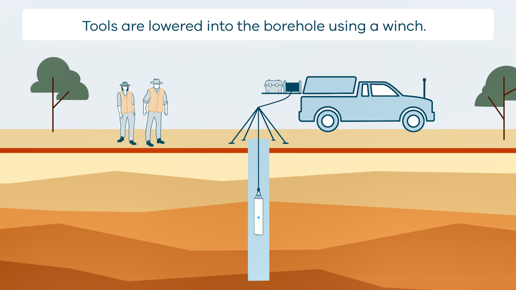
This animation shows how borehole geophysical surveys are conducted. It is part of a series of Field Activity Technique Engagement Animations. The target audience are the communities that are impacted by GA's data acquisition activities. There is no sound or voice over. The 2D animation includes a simplified view of what borehole geophysics equipment looks like, what the equipment measures and how scientists use the data.
-
This technical report details the methods and results the drilling programs of the Upper Burdekin Groundwater Project conducted as part of Exploring for the Future (EFTF)—an eight year, $225 million Australian Government funded geoscience data and information acquisition program focused on better understanding the potential mineral, energy and groundwater resources across Australia. This report was written by Queensland Government collaborators in the Department of Environment and Science, and is published here as supplied to Geoscience Australia at the conclusion of the project. The drilling program itself was conducted by the Department of Environment and Science as part of the Upper Burdekin Groundwater Project. A total of 17 holes were drilled in 2017-18 at 13 sites with a total combined depth of 943.2 metres. These comprise selected locations across both the Nulla Basalt Province and McBride Basalt Province. A network of 15 monitoring bores were constructed with two test holes backfilled and decommissioned.
-
The Western Davenport region has been identified as an area of interest for future agricultural development. However, realisation of this potential depends on access to a reliable supply of groundwater, underpinned by rigorous geological and groundwater information. A three-dimensional stratigraphic model has been created for the Western Davenport area of the Southern Stuart Corridor project under the Exploring for the Future program. Our interpretation integrates airborne electromagnetic data with historical drillhole and outcrop data to improve geological and hydrogeological understanding. Results show that stratigraphies of the Wiso and Georgina basins are equivalent and laterally continuous in this area. This enables a more complete hydrostratigraphy to be defined and underpins improved hydrogeological conceptualisation. New hydrochemical data support the conceptual model that the aquifers of the Wiso and Georgina basins are interconnected at a regional scale. The initial assessment of water quality indicates that groundwater may support further agricultural development. Analysis of new water chemistry data has improved understanding of groundwater processes and potential areas of recharge. This work will inform management decisions to enhance the economic and social opportunities in the Western Davenport area, while protecting the environmental and cultural value of water resources. <b>Citation:</b> Northey, J.E., Clark, A.D., Smith, M.L. and Hostetler, S., 2020. Delineation of geology and groundwater resources in a frontier region: Western Davenport, Northern Territory. In: Czarnota, K., Roach, I., Abbott, S., Haynes, M., Kositcin, N., Ray, A. and Slatter, E. (eds.) Exploring for the Future: Extended Abstracts, Geoscience Australia, Canberra, 1–4.
-
The Exploring for the Future Project Areas web service depicts the spatial extents of project work undertaken as part of Geoscience Australia's $100.5 million initiative dedicated to boosting investment in resource exploration in Australia. Each project area extent has been generated by aggregating all project work sites into an envelope polygon. An indicative spend on each f the projects is also given.
-
The Exploring for the Future Southern Stuart Corridor Groundwater Project undertook extensive multidisciplinary geoscientific investigations across four study areas and six Indigenous communities in central Australia to better understand and characterise groundwater resources. The project was developed to support improvements in water resilience for communities and future agricultural developments in the region. Geoscience Australia collected 9800 line kilometres of airborne electromagnetic data, drilled and installed 15 new monitoring bores, acquired 78 surface nuclear magnetic resonance soundings, recorded downhole geophysical data and groundwater level measurements from >50 bores, and completed hydrochemical analysis of 75 samples. Integration of these datasets provided insights into recharge areas and rates, and potential for managed aquifer recharge. The project also improved our understanding of the geological systems hosting groundwater and interconnections between systems. Potential new groundwater supplies, enhanced understanding of groundwater processes and improved geological models will assist water agencies to better manage groundwater resources across the region. <b>Citation:</b> Hostetler, S., Slatter, E., McPherson, A.A., Tan, K.P., McInnes, D. J., Wischusen, J.D.H. and Ellis, J.H., 2020. A multidisciplinary geoscientific approach to support water resilience in communities in Central Australia. In: Czarnota, K., Roach, I., Abbott, S., Haynes, M., Kositcin, N., Ray, A. and Slatter, E. (eds.) Exploring for the Future: Extended Abstracts, Geoscience Australia, Canberra, 1–4.
-
Salinity of groundwater directly affects its suitability for different uses, including human consumption, stock water, agricultural use, and mineral or energy extraction. Traditionally, direct measurements of groundwater salinity at monitoring bores that intersect an aquifer have been used to map the spatial distribution of groundwater salinity. However, drilling is a logistically and economically challenging task, and we are usually left with a sparse set of measurements from which to infer groundwater salinity over large spatial extents. Airborne electromagnetic (AEM) sounding provides a solution to this problem. This is because AEM can be flown rapidly and cost-effectively over large swathes of land, and high subsurface bulk conductivities inferred from the AEM are well correlated with groundwater salinity in porous aquifers. We present here a methodology and case study from the Keep River Plains in the Northern Territory that provides information for land and watershed managers about the confidence with which salinity can be mapped over large areas using AEM. Extensive pore fluid sampling of the saturated zone, which lies beneath the watertable, enables this workflow to be used effectively. The results provided by our method can feed into decision making while accounting for uncertainty, enabling remote communities to manage their land and water resources effectively. <b>Citation:</b> Symington, N.,Ray, A., Harris-Pascal, C., Tan, K.P., Ley-Cooper, A.Y., and Brodie, R.C., 2020. Groundwater salinity estimation using borehole and AEM data: a framework for uncertainty analysis. In: Czarnota, K., Roach, I., Abbott, S., Haynes, M., Kositcin, N., Ray, A. and Slatter, E. (eds.) Exploring for the Future: Extended Abstracts, Geoscience Australia, Canberra, 1–4.
-
Groundwater is an essential part of Darwin’s water supply mix, and is sourced from Howard East Borefield (HEB) and McMinns Borefield in the Koolpinyah Dolostone Aquifer (KDA), east of Darwin. Previous work suggested that electrical conductivity anomalies observed in airborne electromagnetic (AEM) data within 8 km of HEB may be caused by saline groundwater within the KDA that is separated from HEB by geological features that effectively compartmentalise the aquifer. Nevertheless, concerns grew that increased groundwater use may result in migration of saline groundwater towards HEB, which could compromise the groundwater resource. We collected hydrochemistry, including isotopes, time-series groundwater salinity and AEM data to better understand the complexities of the KDA. These data are presented here, along with a hydrodynamic analysis undertaken by the Northern Territory Department of Environment and Natural Resources, which shows that drawdown is occurring more rapidly from the NE of HEB and that dykes ~8 km NE of HEB act as barriers to groundwater flow. We show that groundwater sampled on the NE side of these dykes has a seawater composition. We use new AEM data to map the elevation of the top of unweathered dyke material and to characterise AEM conductors proximal to HEB. Our mapping reveals that the top of the unweathered portion of these dykes is commonly below sea level. We also show that AEM conductors proximal to HEB are more likely mineralised clays than saline groundwater within the aquifer. Drilling is required to confirm these results. Our findings contribute to building a robust conceptual understanding of the KDA and will inform future modelling of the groundwater system. <b>Citation:</b> Haiblen, A.M., Symington, N.J., Woltmann, M.J., Ray, A., Gow, L.J., Leplastrier, A. and McGrath, E.S.B., 2020. A multifaceted approach to investigating hydrogeological complexities in the Koolpinyah Dolostone Aquifer, Howard East, Northern Territory. In: Czarnota, K., Roach, I., Abbott, S., Haynes, M., Kositcin, N., Ray, A. and Slatter, E. (eds.) Exploring for the Future: Extended Abstracts, Geoscience Australia, Canberra, 1–4.
-
This Daly Basin dataset contains descriptive attribute information for the areas bounded by the relevant spatial groundwater feature in the associated Hydrogeology Index map. Descriptive topics are grouped into the following themes: Location and administration; Demographics; Physical geography; Surface water; Geology; Hydrogeology; Groundwater; Groundwater management and use; Environment; Land use and industry types; and Scientific stimulus. The Daly Basin is a geological formation consisting of Cambrian to Ordovician carbonate and siliciclastic rocks, formed approximately 541 million to 470 million years ago. The basin stretches about 170 km in length and 30 km in width, shaped as a northwest elongated synform with gentle dips of less than 1 degree, likely due to prolonged sedimentary deposition in the shallow seas of the Centralian Superbasin, possibly along basin-scale faults. The primary groundwater reservoir within the Daly Basin is found in the Cambrian Daly River Group. This group comprises three units: the Tindall Limestone, Jinduckin Formation, and Oolloo Dolostone. The Tindall Limestone, which lies at the base, consists of grey, mottled limestone with some maroon-green siltstone or dark grey mudstone. The transition from the Tindall Limestone to the overlying Jinduckin Formation is marked by a shift from limestone to more siliciclastic rocks, indicating a change from open-shelf marine to peri-tidal environments. The Jinduckin Formation, situated above the Tindall Limestone, is composed of maroon-green dolomitic-siliciclastic siltstone with interbeds of dolomitic sandstone-siltstone, as well as dolostone and dolomitic quartz sandstone lenses. It gradually transitions into the carbonate-rich Oolloo Dolostone, with the highest finely laminated dolomitic sandstone-siltstone interbeds at the top of the Jinduckin Formation. The Oolloo Dolostone, the uppermost unit of the Daly River Group, comprises two members: the well-bedded lower Briggs Member, consisting of fine- to medium-grained crystalline dolostone and dolomitic quartz sandstone, and the massive upper King Member. Overlying the Daly River Group is the Ordovician Florina Formation, consisting of three carbonate intervals separated by two fine-grained, glauconite-bearing quartz sandstone units. The Florina Formation and the Daly River Group are covered unconformably by Cretaceous claystone and sandstone of the Carpentaria Basin, which extends over a significant portion of the Daly Basin.
-
This service provides access to airborne electromagnetics (AEM) derived conductivity grids in the Upper Darling Floodplain region. The grids represent 30 depth intervals from modelling of AEM data acquired in the Upper Darling Floodplain, New South Wales, Airborne Electromagnetic Survey (https://dx.doi.org/10.26186/147267), an Exploring for the Future (EFTF) project jointly funded by Geoscience Australia and New South Wales Department of Planning and Environment (NSW DPE). The AEM conductivity model delineates important subsurface features for assessing the groundwater system including lithological boundaries, palaeovalleys and hydrostatigraphy.