topographic
Type of resources
Keywords
Publication year
Service types
Topics
-
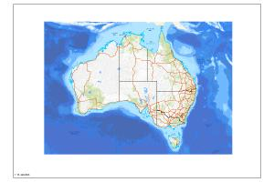
The Australian Topographic map service is seamless national dataset coverage for the whole of Australia. The map portrays detailed graphic representation of features that appear on the Earth's surface. These features include cultural, hydrography and relief themes. SS, MS and LS refer to Small, Medium and Large Scale datasets.
-
The service includes an outline of the Australian shoreline. The information was derived from the Geodata 3 Topographic 250K 2007 data, with a nominal scale of 1:250,000. It is a cached service with a Web Mercator Projection.
-
Online map index of 1:100 000 scale topographic map sheets covering Australia. The application allows users to search, select and download 100k topographic maps with redirection to the relevant eCat record. This is available as an interactive web map.
-
Online map index of 1:250 000 scale topographic map sheets covering Australia. The application allows users to search, select and download 250k topographic maps with redirection to the relevant eCat record. This is available as an interactive web map.
-
The service includes an outline of the Australian shoreline. The information was derived from the Geodata 3 Topographic 250K 2007 data, with a nominal scale of 1:250,000. It is a cached service with a Web Mercator Projection.
-
The Australian Topographic base map service is seamless national dataset coverage for the whole of Australia. The map is a representation of the Geoscience Australia 250k topographic specification and portrays a detailed graphic representation of features that appear on the Earth's surface. These features include cultural, hydrography and relief themes. The service contains layer scale dependencies.
-
Online map index of 1:1 million scale topographic map sheets covering Australia. The application allows users to search, select and download 1 million scale topographic maps with redirection to the relevant eCat record. This is available as an interactive web map.
-
These maps have been aggregated for distribution by Client Services for distribution to wholesale clients or any stakeholder requiring the whole collection of 1:50,000, 1:100,000, 1:250,000 and 1:1,000,000 topographic maps. They are not to be used for any other purpose. They are stored in an AWS S3 bucket and require a timed download link to be created for clients to use. Instructions on how are included. The 50k maps have been broken down into six parts for ease of download.
-
The service includes an outline of the Australian shoreline. The information was derived from the Geodata 3 Topographic 250K 2007 data, with a nominal scale of 1:250,000. It is a cached service with a Web Mercator Projection.