Islands
Type of resources
Keywords
Publication year
Service types
Topics
-
These data are best suited to graphical applications. These data may vary greatly in quality depending on the method of capture and digitising specifications in place at the time of capture. Major island features have been included from the LOSAMBA coastline data capture around the Coral Sea area. 250K Specification Description - Island - An area of land fully surrounded by the sea. (Source - http://www.ga.gov.au/mapspecs/topographic/v6/appendixA_files/Framework.html)
-
The National Base Map - without labels service provides seamless topographic colour mapping for the whole of Australia, including the outer islands of Norfolk, Lord Howe & Macquarie Islands, the external territories of Cocos (Keeling), Christmas, Heard and McDonald Islands and the Australian Antarctic Territory. The service consists of data sourced from Geoscience Australia, Australian Antarctic Division & OpenStreetMap. The data for Christmas Island has been sourced from the Christmas Island Edition 1 NATMAP Topographic Mapping dataset (1:30,000 scale). The data for Cocos (Keeling) Islands has been sourced from the Cocos (Keeling) Islands Edition 1 NATMAP Topographic Mapping dataset (1:25,000 scale). Vegetaion for the the Australian continent is an aggregated layer from ACLUMP (Australian Collaborative Land Use and Management Program). The topographic information was checked in 2008 using satellite imagery, and supplemented using other sources in 2009. Limited field checking has been undertaken for these data and therefore some information may not be accurate. Information and assistance was supplied by the Attorney General's Department (Territories of Australia) and Department of Environment, Water, Heritage and the Arts (Parks Australia). Geoscience Australia gratefully acknowledges contibutions to data content.) When viewing the map of mainland Australia beyond 1:100,000 scale, the data is derived from the Geoscience Australia GEODATA TOPO 250K product, except roads which are OpenStreetMap data, and in from 1:100,000 scale the data is derived from OpenStreetMap data ( © OpenStreetMap contributors). The suburbs layer is sourced from the Suburb 2018 and 2020 data, Australian Bureau of Statistics. The map portrays detailed graphic representations of features that appear on the Earth's surface. These features include cultural, hydrography, marine, transport, vegetation and relief themes. The SRTM data was acquired by NASA in February 2000 and was publicly released under Creative Commons licensing from November 2011 in ESRI Grid format. The SRTM DEM has quite different characteristics to DEMs derived by interpolation from topographic data. The SRTM data is derived from radar measurements that are dense (there is essentially a measurement at almost every grid cell) but noisy. The main processing of the SRTM DEM product has included: stripe removal, void filling and vegetation offset removal. Processing methods are further described in the 1 and 3 second SRTM Derived Products User Guide (Geoscience Australia, 2011). The bathymetry image used for this map is sourced from Natural Earth. Free vector and raster map data @ naturalearthdata.com. This version of the base map does not have any labelling associated with the map.
-
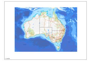
The Australian Topographic base map service is seamless national dataset coverage for the whole of Australia. The map is a representation of the Geoscience Australia 250k topographic specification and portrays a detailed graphic representation of features that appear on the Earth's surface. These features include cultural, hydrography and relief themes. The service contains layer scale dependencies.
-
The National Base Map service provides seamless topographic colour mapping for the whole of Australia, including the outer islands of Norfolk, Lord Howe & Macquarie Islands, the external territories of Cocos (Keeling), Christmas, Heard and McDonald Islands and the Australian Antarctic Territory. The service consists of data sourced from Geoscience Australia, Australian Antarctic Division & OpenStreetMap. The data for Christmas Island has been sourced from the Christmas Island Edition 1 NATMAP Topographic Mapping dataset (1:30,000 scale). The data for Cocos (Keeling) Islands has been sourced from the Cocos (Keeling) Islands Edition 1 NATMAP Topographic Mapping dataset (1:25,000 scale). Vegetaion for the the Australian continent is an aggregated layer from ACLUMP (Australian Collaborative Land Use and Management Program). The topographic information was checked in 2008 using satellite imagery, and supplemented using other sources in 2009. Limited field checking has been undertaken for these data and therefore some information may not be accurate. Information and assistance was supplied by the Attorney General's Department (Territories of Australia) and Department of Environment, Water, Heritage and the Arts (Parks Australia). Geoscience Australia gratefully acknowledges contibutions to data content.) When viewing the map of mainland Australia beyond 1:100,000 scale, the data is derived from the Geoscience Australia GEODATA TOPO 250K product, except roads which are OpenStreetMap data, and in from 1:100,000 scale the data is derived from OpenStreetMap data ( © OpenStreetMap contributors). The suburbs layer is sourced from the Suburb 2018 and 2020 data, Australian Bureau of Statistics. The map portrays detailed graphic representations of features that appear on the Earth's surface. These features include cultural, hydrography, marine, transport, vegetation and relief themes. The SRTM data was acquired by NASA in February 2000 and was publicly released under Creative Commons licensing from November 2011 in ESRI Grid format. The SRTM DEM has quite different characteristics to DEMs derived by interpolation from topographic data. The SRTM data is derived from radar measurements that are dense (there is essentially a measurement at almost every grid cell) but noisy. The main processing of the SRTM DEM product has included: stripe removal, void filling and vegetation offset removal. Processing methods are further described in the 1 and 3 second SRTM Derived Products User Guide (Geoscience Australia, 2011). The bathymetry image used for this map is sourced from Natural Earth. Free vector and raster map data @ naturalearthdata.com.