rail
Type of resources
Keywords
Publication year
Service types
Scale
Topics
-
GEODATA TOPO 250K Series 3 is a vector representation of the major topographic features appearing on the 1:250,000 scale NATMAPs. Data is arranged within specific themes. All data is based on the GDA94 coordinate system. The 250K transport data used in the National Map base map are seamless national datasets and cover the whole of Australia. The transport datasets have been updated since the GEODATA TOPO 250K Series 3 release.
-
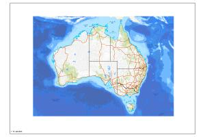
The Australian Topographic map service is seamless national dataset coverage for the whole of Australia. The map portrays detailed graphic representation of features that appear on the Earth's surface. These features include cultural, hydrography and relief themes. SS, MS and LS refer to Small, Medium and Large Scale datasets.
-
Railway network extracted from Digital Chart of the World (DCW) Transport dataset (dataset derived from the Digital Chart of the World). Generic information on DCW data sets The primary source for DCW is the US Defense Mapping Agency (DMA) Operational Navigation Chart (ONC) series produced by the United States, Australia, Canada, and the United Kingdom. The ONCs have a scale of 1:1,000,000, where 1 inch equals approximately 16 miles.The charts were designed to meet the needs of pilots and air crews in medium and low altitude en route navigation and to support military operational planning, intelligence briefings, and other needs. Therefore, the selection of ground features is based on the requirement for rapid visual recognition of significant details seen from a low perspective angle. The DCW database was originally published in 1992. Data currency varies from place to place depending on the currency of the ONC charts. Chart currency ranges from the mid 1960s to the early 1990s. Compilation dates for every ONC chart are included in the database. For more information on the Digital Chart of the world, please browse the DCW website where you can download these data in VPF format. GA has converted these VPF format files to common GIS formats Arcview and Mapinfo. Available datasets include drainage, roads and railway networks, political areas and boundaries and population centres. Available for free download.
-
This service has been created specifically for display in the National Map and the chosen symbology may not suit other mapping applications. The Australian Topographic web map service is seamless national dataset coverage for the whole of Australia. These data are best suited to graphical applications. These data may vary greatly in quality depending on the method of capture and digitising specifications in place at the time of capture. The web map service portrays detailed graphic representation of features that appear on the Earth's surface. These features include aviation, physiography, road transport and rail transport themes from the Geoscience Australia 250K Topographic Data. The service contains layer scale dependencies.
-
The Australian Topographic base map service is seamless national dataset coverage for the whole of Australia. The map is a representation of the Geoscience Australia 250k topographic specification and portrays a detailed graphic representation of features that appear on the Earth's surface. These features include cultural, hydrography and relief themes. The service contains layer scale dependencies.