places
Type of resources
Keywords
Publication year
Service types
Topics
-
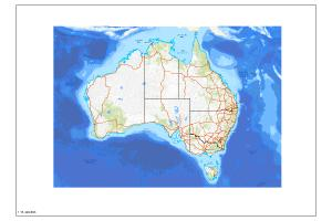
The Australian Topographic map service is seamless national dataset coverage for the whole of Australia. The map portrays detailed graphic representation of features that appear on the Earth's surface. These features include cultural, hydrography and relief themes. SS, MS and LS refer to Small, Medium and Large Scale datasets.
-
The Gazetteer provides information on the location and spelling of more than 370,000 geographical names across Australia as at January 2012. The supply of data is coordinated by the Intergovernmental Committee on Surveying and Mapping and derived from State, Territory and Australian Government agencies. Copyright of the Gazetteer data resides with the relevant state, territory and Australian Government agencies which are custodians of the data. The Gazetteer fields include: - Record ID - unique feature identifier for each feature. - Authority ID - custodian state or territory. - State ID - state or territory which contains the feature. - Name - name of the feature. - Feature Code - code indicating the type of feature - Status - indicates whether the name is authorised. - Variant name - variant or alternative name used for the feature. - Postcode - Postcode for the feature. - Concise Gazetteer - indicates whether the feature is included in the concise gazetteer. - Longitude - longitude of the feature in decimal degrees. - Latitude - latitude of the feature in decimal degrees. - 100K map number - 1:100 000 scale map number in which the feature is located. - CGDN - indicates whether the place name can be used in the state.au second level domains by community website portals which reflect community interests. Product specifications: - Coverage: Australia - Currency: 2012 - Coordinates: Geographical - Datum: GDA94 - Format: Microsoft Access Database, KML, GML - Medium: WEB - Forward Program: Annual revision Please note: The custodians of the place name data do not guarantee that the data is free from errors and omissions. If possible errors or omissions in the data are identified, please contact gazetteer@ga.gov.au Corrections are forwarded to the State and Territories, Name Authorities for clarification. Updates will appear in subsequent revisions of the Gazetteer.
-
The Australian Topographic base map service is seamless national dataset coverage for the whole of Australia. The map is a representation of the Geoscience Australia 250k topographic specification and portrays a detailed graphic representation of features that appear on the Earth's surface. These features include cultural, hydrography and relief themes. The service contains layer scale dependencies.