20000000
Type of resources
Keywords
Publication year
Scale
Topics
-
The Atlas of Australian Soils (Northcote et al, 1960-68) was compiled by CSIRO in the 1960's to provide a consistent national description of Australia's soils. It comprises a series of ten maps and associated explanatory notes, compiled by K.H. Northcote and others. The maps are published at a scale of 1:2,000,000, but the original compilation was at scales from 1:250,000 to 1:500,000. Mapped units in the Atlas are soil landscapes, usually comprising a number of soil types. The explanatory notes include descriptions of soils landscapes and component soils. Soil classification for the Atlas is based on the Factual Key. This dataset has been modified to show only soil types. For more information go to http://www.asris.csiro.au/themes/Atlas.html
-
This map is a compact general reference map (A4 size, approximate 1:20 million scale) that has been designed for inclusion in publications requiring a simple, small size, multicoloured map of Australia. The map depicts a selection of the major geographic and cultural features that helps the user quickly familiarise themselves with the continent. This is a smaller scale version of the Australia 1:9 Million Compact General Reference Map, Edition 2.
-
A simple blackline map of the outline of Australia, suitable to be printed at A4 or A3 size.
-
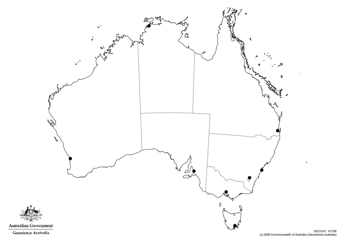
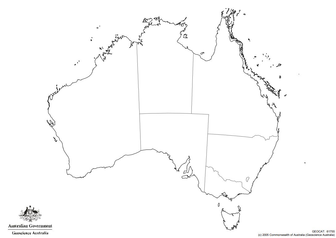
Outline map of Australia (with state borders and capital city locations)
-
An A4 brochure folds out to an A2 sheet, containing a map and text about The Ice Continent; The Southern Ocean; Upper Atmosphere Phenomena; The Antarctic Treaty System; and The Antarctic Program. One side features a beautifully presented geographic map (594 x 420mm), brightly coloured with relief drawing and bathymetry. Claim and Treaty boundaries are shown, as well as a distance matrix.
-
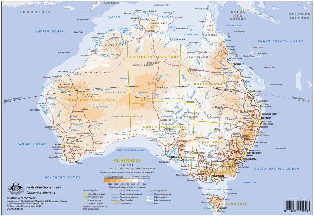
The Australia Report Map is A4 size, approximate scale 1:20 million. This map is a smaller-scale version of the 1:9 million Compact General Reference Map. It depicts the major features of the continent, allowing users to quickly familiarise themselves with the Australian landscape and geography. This map can be purchased in flat format through Geoscience Australia`s Sales Centre or our map retailers located throughout every State and Territory of Australia. A free download is also available below.
-
This map extends from Iran in the west to the United States in the east. It includes national borders, country names, capitals and other major cities. It shows deserts, mountain ranges, lakes, rivers, roads and railways. For the first time ever on a single map that is double sided with detailed maps on the reverse map.Hong Kong and Singapore plus 11 island nations and groups appear in detail on the reverse. The 13 individual maps show the Cook Islands, Fiji, French Polynesia, Guam, Hawaii, Hong Kong, Nauru, New Caledonia, Samoa, Singapore, the Solomon Islands, Tonga and Vanuatu. The Asia Pacific region is an important world area, and this map is a valuable reference for business people, teachers, students, travellers and the general public. Product Specifications Coverage: 60E to 110W; 50N to 55S. Includes south-east Asia, Australia, the Pacific ocean, and parts of North America Currency: 1994 Coordinates: Geographical Projection: Millers
-
Outline map of Australia (with state borders)
-
Geoscience Australia distributes a range of Antarctica maps and images at various scales and currency, on behalf of Australian Antarctic Division. These products are very diverse and include topographic maps and satellite images, ranging from landscape specific (1:1,000 scale) to regional (1:20,000,000) scale.