TECHNOLOGY
Type of resources
Keywords
Publication year
Topics
-
The Girls in STEM statement addresses Strategy 2028 impact area of ‘enabling an informed Australia’ by increasing earth science literacy and engagement while addressing issues of diversity and inclusion. The Statement articulates Geoscience Australia’s efforts to engage girls in STEM, particularly as it relates to our education program.
-
The Queensland corner reflector array is increasingly being used as a globally unique calibration and validation infrastructure for orbiting Synthetic Aperture Radar sensors. In May and June 2018, Geoscience Australia undertook field survey work at all 40 corner reflector sites to compute a more accurate determination of the position of the corner reflector apex point. This Geoscience Australia Record describes the design and procedure of the field surveys, and the data processing undertaken to arrive at new positions and associated uncertainties for each corner reflector apex point. The positions we report here supersede those that were previously published by Garthwaite et al. (2015a). We also report here the orientation of each corner reflector (at the time of survey) calculated from the new survey observations. We find that the corner reflector orientations (i.e. azimuth and elevation of the corner reflector boresight) are within 2 degrees of the values used during post-installation alignment in 2014.
-
The gnssanalysis Python package is designed to provide the public with a source of useful python functions and classes that help with processing of GNSS observations. The functionality found within the package includes: - reading of many standard file formats commonly used in the geodetic community including SP3, SNX, RNX, CLK, PSD, etc. into pandas dataframes (Also writing certain file formats) - transformation of data, for example datetime conversions, helmert inversions, rotations, transforming geodata from XYZ to longitude-latitude-altitude, etc. - functions for the download of standard files and upload to other sources (e.g. s3)
-
All commercially produced hydrogen worldwide is presently stored in salt caverns. Through the Exploring for the Future program, Geoscience Australia is identifying and mapping salt deposits in Australia that may be suitable for hydrogen storage. The only known thick salt accumulations in eastern Australia are found in the Boree Salt of the Adavale Basin in central Queensland, and represent potentially strategic assets for underground hydrogen storage. The Boree Salt consists predominantly of halite that is up to 555 m thick in some wells. In 2021, Geoscience Australia contracted Intrepid Geophysics to develop a 3D geological model of the Adavale Basin, using well data and 2D seismic interpretation and focussing on the Boree Salt deposit. The 3D model has identified three main salt bodies that may be suitable for salt cavern construction and hydrogen storage. Further work and data acquisition are required to fully assess the suitability of these salt bodies for hydrogen storage. Disclaimer Geoscience Australia has tried to make the information in this product as accurate as possible. However, it does not guarantee that the information is totally accurate or complete. Therefore, you should not solely rely on this information when making a commercial decision. This dataset is published with the permission of the CEO, Geoscience Australia.
-
Many scientific talks by Geoscience Australia staff are published on YouTube. These documents provide summaries (‘crib sheets’) of the presentations along with easy access links to each part of the video. They are intended to help teachers of Year 11/12 classes learning about natural hazards
-
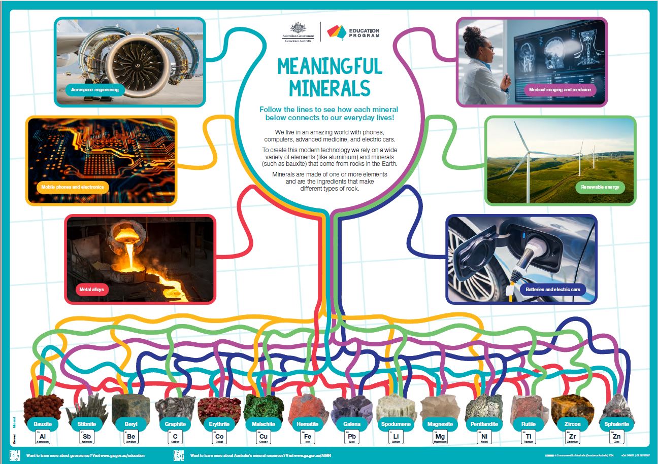
<div>This A1 poster aims to introduce Year 3/4 and older students to the many ways that minerals and elements are used in our everyday lives. </div><div> 6 key uses of 14 critical and strategic minerals are highlighted by colourful lines linking images. Students should take their time viewing the poster; they can follow the wiggly lines from minerals to product or vice versa and work out how many minerals link to each type of use.</div><div> The poster is also suitable for secondary students with the inclusion of a specific element name with each highlighted mineral plus the element symbol and atomic number.</div><div> The poster is intended to be a colourful rich stimulus to engage student interest in the resources from the ground used in our modern world.</div><div><br></div>
-
<p>Digital Earth Australia manages a cloud based service that makes use of open source software and open standards to deliver satellite imagery to its clients. <p>In conjunction with Frontier SI and Commonwealth Scientific and Industrial Research Organisation, Geoscience Australia’s Digital Earth Australia project has developed a cloud architecture that utilizes the Open Data Cube (ODC) to deliver Earth Observation (EO) data through Open Geospatial Consortium (OGC) API standards, interactive Jupyter notebooks and direct file access. <p>This infrastructure enables EO data to be used to make decisions by industry and government partners, and reduces the time required to deliver new EO data products. <p>To store the data, DEA utilises Amazon Web Services (AWS) Object store: Simple Storage Service (S3) to hold an archive of Cloud Optimised GeoTIFFs (COGs). <p>This data is indexed by Open Data Cube (ODC) an open source python library. DEA deploy processing, visualisation and analysis applications that make use of the indexed data. This method reduces the duplication of code and effort and creates an extensible framework for delivering data.
-
Millions of data points have been acquired or compiled through both phases of the Exploring for the Future (EFTF) program at Geoscience Australia (GA). This data that graces the EFTF Portal and appears in many publications has another home within specialist databases designed and built to house the specific data that GA collects. One such database is HYDROCHEM, which was implemented as part of the Enhanced Data Delivery (EDD) and National Groundwater Systems (NGS) projects. HYDROCHEM hosts 190,097 rows of groundwater, surface water and rainfall water chemistry analyses. This data was either previously hosted in the GNDWATER database, or compiled from legacy data stores. The redevelopment of GNDWATER to HYDROCHEM saw the de-duplication and updating of sample and site-specific metadata into other GA databases, such as SAMPLES, BOREHOLES and FIELDSITES. The redevelopment also added additional constraints to the database, including minimum metadata requirements, constrained look-up tables for units of measure, laboratory, method, filter sizes, standards and uncertainty types. Other features include minimum and maximum values for particular analytes and delivery of the data in standardised GA-preferred units of measure.
-
<p>On 5 November 2019, Geoscience Australia presented a Targeted Side Event at the GEO Week 2019 Ministerial Summit in Canberra (http://www.earthobservations.org/geoweek19.php?t=home). GEO, the Group on Earth Observations, is a global intergovernmental partnership of 105 Member governments, 127 Participating Organizations and thousands of individuals and businesses that strives to improve the availability, access and use of Earth observations for a more sustainable planet. <p>The theme of the Targeted Side Event was as follows. <p>Strong, resilient and sustainable communities have jobs, homes, clean water, feel safe and are well connected locally, nationally and internationally. Government, business, industry and community decision makers can progress economic, social and cultural development using new, free digital information and mapping tools. Smart, fast and trusted decisions made using digital information and digital mapping can be used for any sized community, remote, rural, city, national. Sustainable development, responsible growth through a reform and transform approach can unlock new resource opportunities and respond to the economic and social challenges faced by many countries. Presented is a new digital mapping decision making tool that integrates resources: minerals, energy and water, within a social, economic and environment frame. <p>Addressing social licence and environmental sustainability is becoming increasingly important to ensuring the future economic development of Earth resources. The challenge for geoscientists is to create tools using data integrated from multiple disciplines to deliver insight into the complex interactions between diverse Earth systems and human society. These tools will enable specialists and non-specialists in communities, government and industry to make informed decisions for a sustainable future.
-
An AusPIX Integration Table for major Australian geographies. Based on the standard AusPIX DGGS 2.4408 hectare plot, this dataset integrates each major geography with all others in the table. It is a core dataset that describes all the AusPIX DGGS level 10 cells in Australia and extends them into a cross-walk that references point, line, polygon, or grid data to those AusPIX DGGS cells. This table can be easily linked to further integrate and reference any other AusPIX enabled dataset available. The Integration set is designed to allow a wide variety of statistical enquiry, as well as visualisation of data and outputs. For example Python Pandas can consume csv downloads of selected parts of this database to allow employment of all Pandas functions. For visualisation, QGIS can connect (and visualise on the desktop), your SQL queries on the database for example. This table is a 430 million row PostgreSQL database provisioned on AWS. It can be filtered and searched using SQL, and results can be downloaded to CSV. It is a pre-calculated dataset using the 'AusPIX framework for data integration, statistics and visualisation by DGGS Location (linked in "Associations" in the panel on the right). An API over the top of this dataset is available at: https://api.dggs.ga.gov.au/docs