density
Type of resources
Keywords
Publication year
Service types
Topics
-
3D constrained gravity inversions have been applied to gravity data in the Cooper Basin region of South Australia to delineate low density regions within the basement, beneath thick sequences of sedimentary cover. The low density regions, which are interpreted as granite bodies, may act as heat sources beneath thermally insulating sediments, thereby enhancing geothermal prospectivity. The Cooper Basin is the site of Australia's first geothermal project , where elevated crustal temperatures result from high-heat producing granites of the Big Lake Suite beneath the basin sediments. A 3D map of sediment stratigraphy was populated with densities and used to constrain the contribution of low density cover sediments to the observed gravity field. The resulting constrained density inversion model produced low density regions in the basement that coincide with local gravity lows. Further gravity inversions were generated and combined with gravity worm data to constrain the lateral and vertical extent of these discrete low density regions which we interpret as granite bodies. These Interpreted Granite Bodies (IGBs) coincide with granites intersected in wells. Analyses of a regional thermal model generated for a previous study, indicate that extra heat-production is required in the regions of the model that coincide with a number of the IGBs. Further thermal modelling was undertaken to determine the heat production differential between these high-heat producing IGBs and the surrounding basement. Two regions were identified where the high-heat producing IGBs are located beneath thick sequences of thermally insulating sediments. These regions, located to the east of the Big Lake Suite granodiorite and in the centre of the study area coinciding with the Barrolka gravity low, are considered to have high geothermal prospectivity.
-
This OGC WFS web service (generated by Geoserver) serves data from the Geoscience Australia Rock Properties database. The database stores the results of measurements of physical properties of rock and regolith specimens, including such properties as mass density, magnetic susceptibility, magnetic remanence and electrical conductivity. The database also records analytical process information such as method and instrument details where possible.
-
This OGC WMS web service (generated by Geoserver) serves data from the Geoscience Australia Rock Properties database. The database stores the results of measurements of physical properties of rock and regolith specimens, including such properties as mass density, magnetic susceptibility, magnetic remanence and electrical conductivity. The database also records analytical process information such as method and instrument details where possible.
-
The physical properties of non-porous basement rocks are directly related to the mineralogy of those rocks. The MineralMapper3D software package originally developed by Nick Williams at the Predictive Mineral Discovery Cooperative Research Centre (pmd*CRC), Geoscience Australia, uses the physical properties of minerals to provide bounds on estimates of the abundance of specified minerals in non-porous basement rocks. This approach is applicable to both estimates of density and magnetic susceptibility derived from 3D inversions of gravity and magnetic data as well as physical measurements on specimens or down-hole derived physical properties. This users guide descibes the history, installation and operation of the software package.
-
The Geoscience Australia Rock Properties database stores the results measurements of scalar and vector petrophysical properties of rock and regolith specimens. Many are sourced from Geoscience Australia's mapping and research programs, but some are are compiled from published literature, university studies, the resources industry and State/Territory geological surveys. Measured properties include mass density, magnetic susceptibility, magnetic remanence, gamma, electrical conductivity and sonic velocity. The database also records analytical process information such as methods and instrument details wherever possible.
-
<div>National Exposure Information System (NEXIS) Residential Dwelling Density is a set of four raster layers representing the density of residential dwellings across Australia at different scales and resolutions. A dwelling is defined as self-contained suites of rooms including cooking and bathing facilities and intended for long-term residential use. Such dwelling units include houses-detached buildings used for long-term residential purposes-and other dwellings including flats. NEXIS collates the best publicly-available information, statistics, spatial and survey data into comprehensive and nationally-consistent exposure information datasets. Where data is limited, models are used to apply statistics based on similar areas. Exposure Information products are created at the national, state or local level to understand the elements at risk during an event or as a key input for analysis in risk assessments. NEXIS products are not intended for operational purposes at the building or individual feature level. Its strength is to provide consistent aggregated exposure information for individual event footprints or at standard community, local, state and national geographies such as the Australian Bureau of Statistics (ABS) Statistical Areas (SA) or Local Government Areas (LGA). NEXIS Building exposure information consists of Residential, Commercial and Industrial buildings. This information can be used to understand the type, use, age and structural characteristics such as number of storeys, roof type and wall type of the building stock nationally. Building exposure information can also be used to estimate population attributes such as the number of occupants, household income and other demographic indicators, as well as economic impacts based on building construction and replacement costs. The NEXIS Residential Dwelling Density is a national grid-based representation derived from the number and distribution of dwellings produced from the NEXIS residential buildings data. </div><div><br></div><div>Dwelling density is available as a web service displaying the aggregate number of dwellings, at four different raster scales and resolutions, to show the distribution and density of residential dwellings across Australia. Resolutions include 100m, 500m, 1km and 2km rasters.</div><div><br></div><div>Resolutions:</div><div>1. Number of residential dwellings per 100sqm. Visible at zoom scales 1:250,000 minimum with no maximum. </div><div>2. Number of residential dwellings per 500sqm. Visible at zoom scales 1:700,000 minimum with 1:250,001 maximum.</div><div>3. Number of residential dwellings per 1km square. Visible at zoom scales 1:3,000,000 minimum with 1:700,001 maximum. </div><div>4. Number of residential dwellings per 2km square. Visible at zoom scales with no minimum and 1:3,000,001 maximum</div><div> </div><div>This product is based on NEXIS version 15 (2024) data.</div><div><br></div>
-
This repository contains a static version of the data and software that accompanies the article by Stephenson et al. (2024) published in the Journal of Geophysical Research: Solid Earth. Note that the data and software repositories are up to date as of 07/03/2024. For more recent updates users are referred to the primary repositories on Github. Contents of zipped repository files includes four directories: 1. The manuscript directory `STEPHENSON_ET_AL_2024_JGR/` containing - The manuscript file (pre-print before final peer review and acceptance by the journal). - Supplementary text accompanying the manuscript. 2. The `SMV2rho` software package version `v1.0.1` for converting seismic velocity into density. 3. The `SeisCruST` database of global crustal thickness and velocity profiles. 4. The `global-residual-topography` database containing estimates of continental residual topography after correcting for isostatic effects of crustal thickness and density variations. Abstract for the article: Continental topography is dominantly controlled by a combination of crustal thickness and density variations. Nevertheless, it is clear that some additional topographic component is supported by the buoyancy structure of the underlying lithospheric and convecting mantle. Isolating these secondary sources is not straightforward, but provides valuable information about mantle dynamics. Here, we estimate and correct for the component of topographic elevation that is crustally supported to obtain residual topographic anomalies for the major continents, excluding Antarctica. Crustal thickness variations are identified by assembling a global inventory of 26 725 continental crustal thickness estimates from local seismological datasets (e.g. wide-angle/refraction surveys, calibrated reflection profiles, receiver functions). In order to convert crustal seismic velocity into density, we develop a parametrization that is based upon a database of 1 136 laboratory measurements of seismic velocity as a function of density and pressure. In this way, 4 120 new measurements of continental residual topography are obtained. Observed residual topography mostly varies between±1–2 km on wavelengths of 1 000–5 000 km. Our results are generally consistent with the pattern of residual depth anomalies observed throughout the oceanic realm, with long-wavelength free-air gravity anomalies, and with the distribution of upper mantle seismic velocity anomalies. They are also corroborated by spot measurements of emergent marine strata and by the global distribution of intraplate magmatism that is younger than 10 Ma. We infer that a significant component of residual topography is generated and maintained by a combination of lithospheric thickness variation and sub-plate mantle convection. Lithospheric composition could play an important secondary role, especially within cratonic regions.
-
The physical properties of non-porous basement rocks are directly related to the mineralogy of those rocks. The MineralMapper3D software package originally developed by Nick Williams at the Predictive Mineral Discovery Cooperative Research Centre (pmd*CRC), Geoscience Australia, uses the physical properties of minerals to provide bounds on estimates of the abundance of specified minerals in non-porous basement rocks. This approach is applicable to both estimates of density and magnetic susceptibility derived from 3D inversions of gravity and magnetic data as well as physical measurements on specimens or down-hole derived physical properties.
-
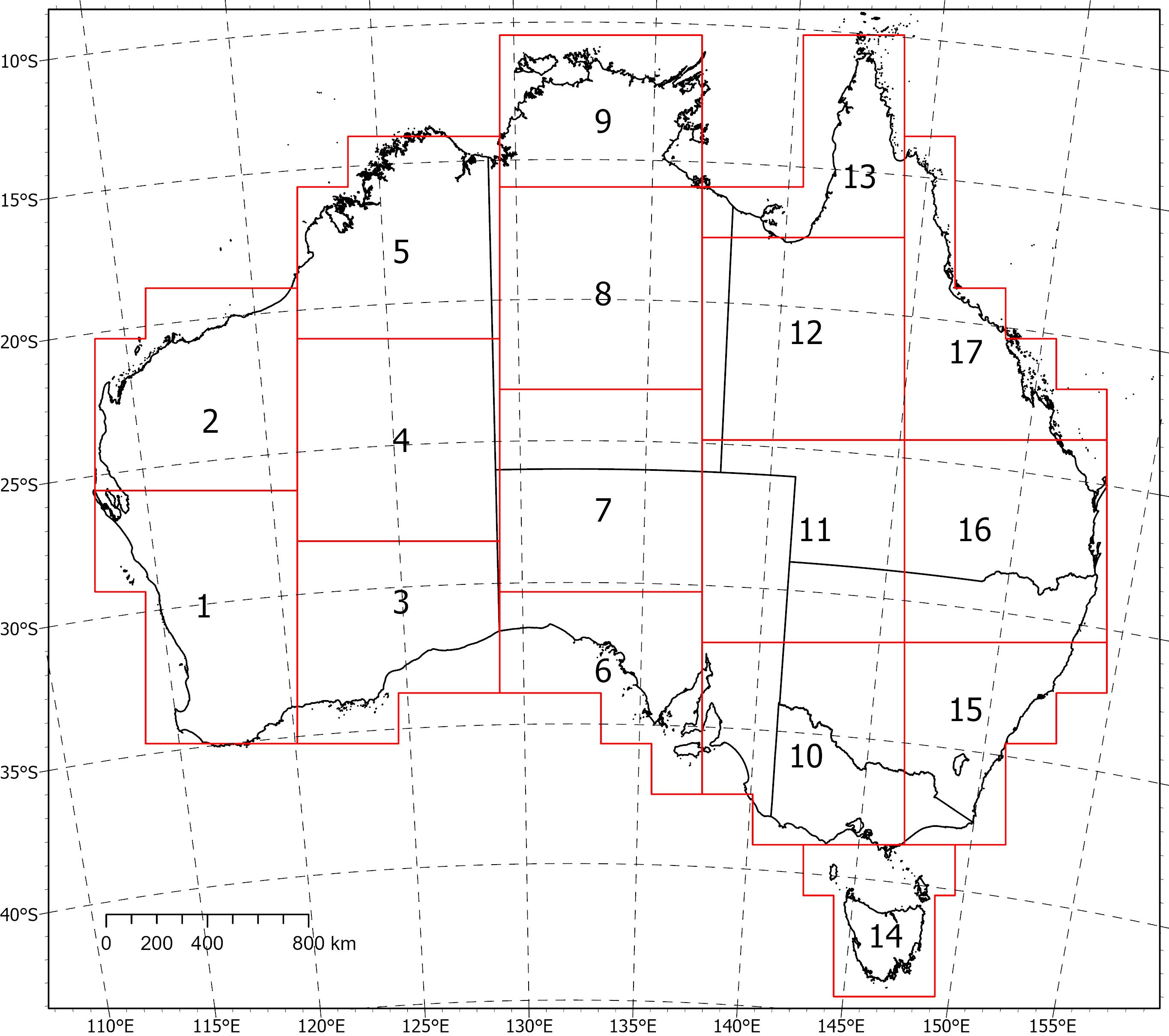
<div>Two coincident, crustal-scale models, one of magnetic susceptibility and one of density, have been produced for a volume covering the Australian continent and extending down to 55.5 km depth. These models were produced using the UBC‑GIF MAG3D and GRAV3D inversion programs, respectively.</div><div><br></div><div>The inversions were constrained with geological reference models with layers for sediments, undifferentiated crust and the mantle. The reference model for the magnetic inversion incorporated a Curie depth surface below which magnetic susceptibility was set to zero.</div><div><br></div><div>Due to the size of the inversion problem to be solved, the volume was divided into 235 overlapping inversions, which were inverted separately and then recombined. The method of recombining the inversions relies on a cosine function to determine the weight of each property and then takes a weighted average. This method successfully attenuated the edge effects that would otherwise occur between models and allows them to be viewed as one seamless model that covers the whole of Australia.</div><div><br></div><div>Regions of coincident high-density (>2.83 g/cm<sup>3</sup>) and high-magnetic susceptibility (>0.0125 SI) within the top 8‑9 km of the undifferentiated crust are suggested to be related to ultramafic rocks and the magnetite-forming hydrothermal alteration stages of potentially fertile IOCG systems. Currently the models are available in UBCGIF format (.den/.sus) only. Other formats and all supporting input data will be added in the near future. Due to their size, the models have been divided into subsets (labelled 1-17) for download. Please refer to the image below for the extent of the subsets.
-
As part of the Exploring for the Future program, whole-of-crust 3D gravity and magnetic inversion models have been produced for an area encompassing the North Australia Craton. These models were created to aid 3D geological mapping and identification of large-scale mineral systems such as those associated with iron oxide copper-gold deposits. The inversion models were derived using the University of British Columbia - Geophysical Inversion Facility MAG3D and GRAV3D programs. The inversions were constrained with geological reference models that had layers for Phanerozoic sediments, Proterozoic sediments, undifferentiated crust and the mantle. The reference model for the magnetic inversion incorporated a Curie depth surface below which magnetic susceptibility was set to zero. To allow cross-referencing, both the density and magnetic susceptibility models were designed to occupy the same physical space with identical volumes and cell sizes. A horizontal cell size of 1 km was used with 61 vertical layers, whose thickness increased with depth. The area of interest is 2450 km by 1600 km and extends to a depth of 70 km below the geoid, resulting in a total volume with ~239 million cells. Ultimately, it was not possible to invert a model of this size. Instead, the volume was broken down into a grid of overlapping tiles with 8 rows and 10 columns. Each tile was independently inverted before being recombined into a single coherent output model. When the overall model was reconstructed using the core region of each tile, some low-level edge effects were observed, increasing in significance with depth. These effects were satisfactorily attenuated by applying cosine weighting from the centre of each tile out to the edge of the overlap region during reconstruction. The coincident density and magnetic susceptibility models show a relationship with known iron oxide copper-gold deposits and regions of >2.80 g/cm3 and >0.01 SI in the Tennant Creek and Cloncurry regions. It is suggested that these regions of high-density and high-magnetic susceptibility are related to the magnetite-forming hydrothermal alteration stages of an iron oxide copper-gold deposit. The success of the NAC modelling exercise has demonstrated that this method can be expanded to produce coincident gravity and magnetic inversion models for the entire Australian region. ------------------------------------------------------------------------------------------ DOWNLOADS ------------------------------------------------------------------------------------------ Input Data: The input gravity, magnetic and elevation data (.ers and .tif). Geological Reference Models: The geological reference model as surfaces and 3D volumes (.sg, .ts, and UBCGIF). Observed vs Predicted Data: The input gravity/magnetic data compared to the predicted data (.png). Recombined Models: The recombined (cosine weighted) density and magnetic susceptibility models (.sg, and UBCGIF). Magnetite Proxies: Proxies for magnetite alteration related to IOCG deposits (.ers). Video: Video describing the method and results (.mp4).