15000000
Type of resources
Keywords
Publication year
Scale
Topics
-
Datum: AGD66, GDA94; AHD Superceeded by GeoCat# 65186
-
The Australia Folio Map is A3 size, approximate scale 1:15 million. This is a smaller-scale version of the 1:9 million Compact General Reference Map, depicting the major features of the continent. This map allow users to quickly familiarise themselves with the Australian landscape and geography. This map can be purchased in flat format only. Sold through Geoscience Australia`s Sales Centre or our map retailers who are located throughout every State and Territory of Australia. Product Specifications Coverage: Complete coverage of Australia Currency: Last revised 1996 Coordinates: No coordinates shown Datum: No horizontal datum; AHD Projection: Simple Conic on two standard parallels (18S and 36S) Medium: Paper, flat copies Forward Program: Will be revised upon completion of small-scale product data revision
-
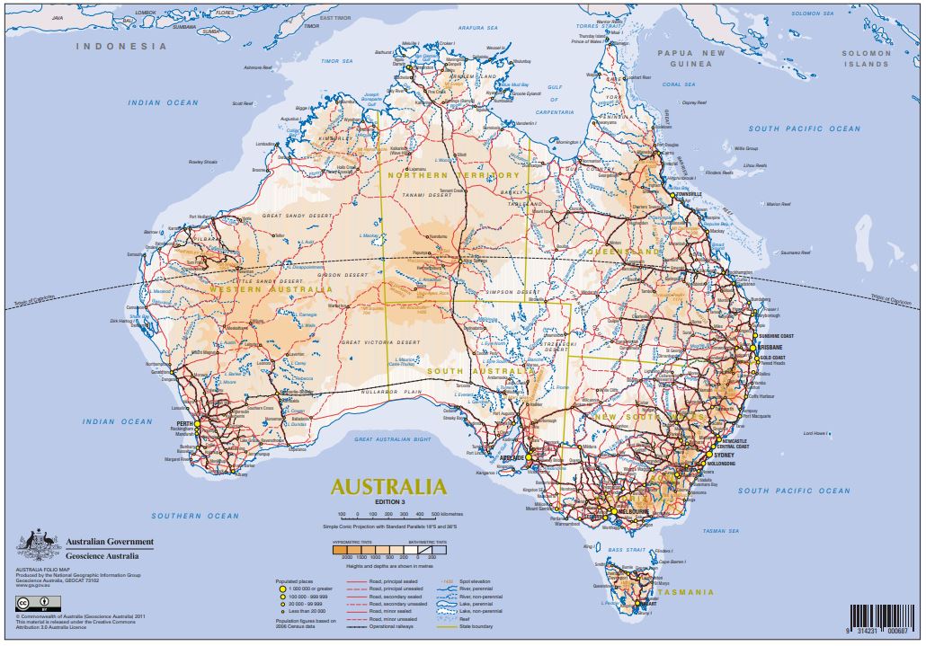
This map is a compact general reference map (A3 size, approximate 1:15 million scale) that has been designed for inclusion in publications requiring a simple, small size, multicoloured map of Australia. The map depicts a selection of the major geographic and cultural features that helps the user quickly familiarise themselves with the continent. This is a smaller scale version of the Australia 1:9 Million Compact General Reference Map, Edition 2.
-
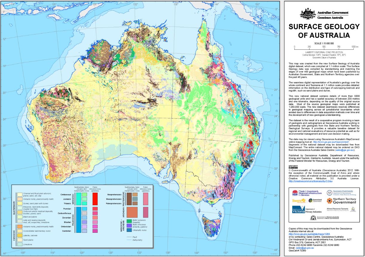
This map was created from the Surface Geology of Australia (1:1M scale) dataset, plotted at 1:15 million scale. The Surface Geology of Australia data was compiled by standardising and edge-matching over 400 geological maps which have been published by Australian Government, State and Territory agencies over the past 40 years. This seamless digital dataset is the most detailed national coverage available of the continent and islands. It provides information on the distribution and type of over 5000 outcropping bedrock and regolith units, such as sand plains and dunes.
-
Map showing all of Australia's Maritime Jurisdiction north of approx 25°S. Updated in June 2014 from "Australia's Maritime Jurisdiction North of 25°S" (GeoCat 71985) to conform with "Australian Maritime Boundaries 2014" data by Geoscience Australia. This includes areas around Cocos (Keeling) Islands and areas around Christmas Island as well as those contiguous to the continent in the north. Included as one of the now 28 constituent maps of the "Australia's Maritime Jurisdiction Map Series" (GeoCat 71789). Depicting Australia's continental shelf as proclaimed in the "Seas and Submerged Lands (Limits of Continental Shelf) Proclamation 2012" established under the "Seas and Submerged Lands Act 1973". Background bathymetry image is derived from a combination of the 2009 9 arc second bathymetry and topographic grid by Geoscience Australia and a grid by W.H.F. Smith and D.T. Sandwell, 1997. Background land imagery derived from Blue Marble, NASA's Earth Observatory. 3277mm x 1050mm (for 42" plotter) sized .pdf downloadable from the web.
-
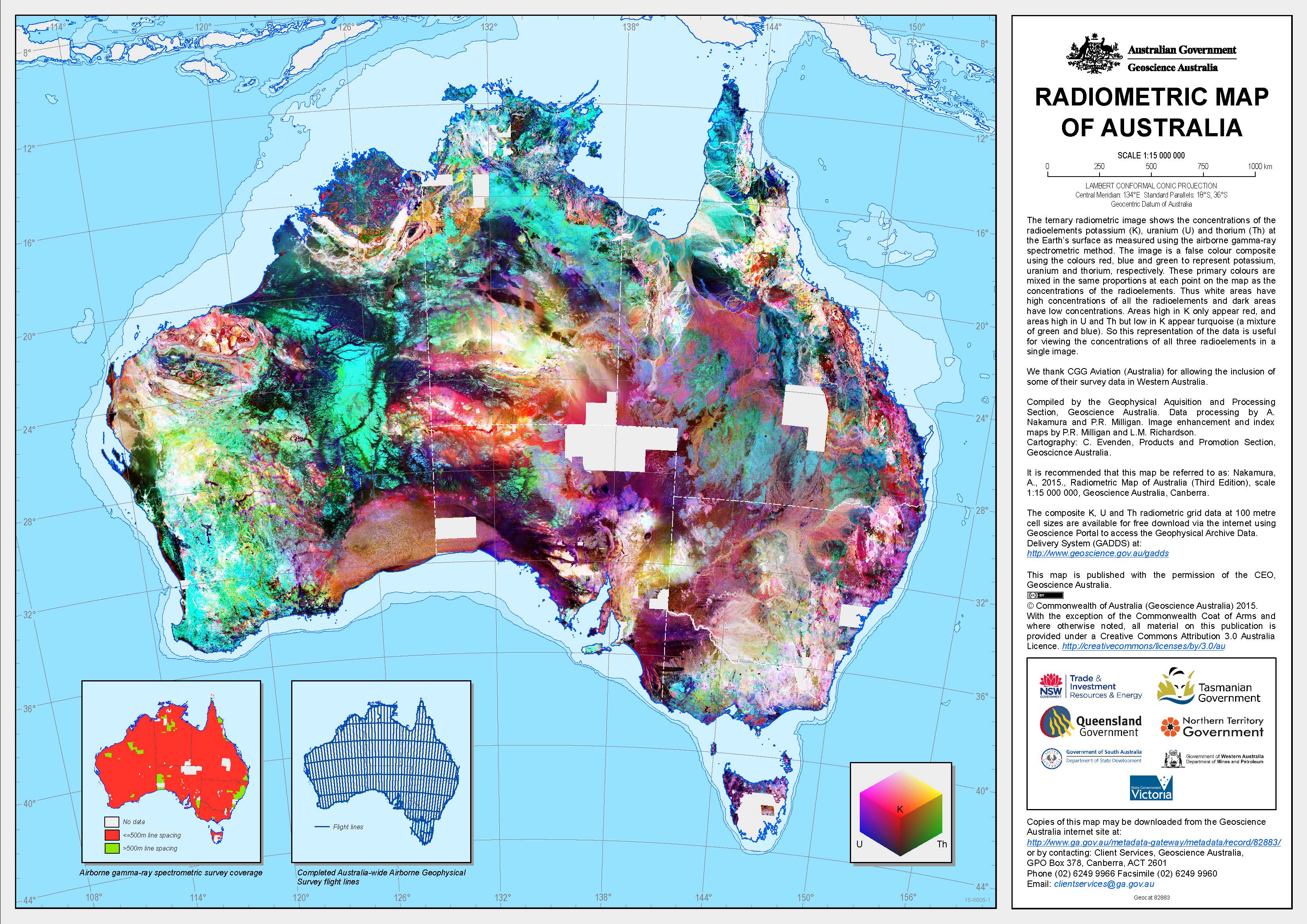
Geoscience Australia and State and Territory Geological Surveys have systematically surveyed most of the Australian continent over the past 40 years using airborne gamma-ray spectrometry to map potassium, uranium and thorium elemental concentrations at the Earth's surface. However, the individual surveys that comprise the national gamma-ray spectrometric radioelement database are not all registered to the same datum. This limits the usefulness of the database as it is not possible to easily combine surveys into regional compilations or make accurate comparisons between radiometric signatures in different survey areas. To solve these problems, Geoscience Australia has undertaken an Australia-Wide Airborne Geophysical Survey (AWAGS), funded under Geoscience Australia's Onshore Energy Security Program, to serve as a radioelement baseline for all current and future airborne gamma-ray spectrometric surveys in Australia. The AWAGS survey has been back-calibrated to the International Atomic Energy Agency's (IAEA) radioelement datum. We have used the AWAGS data to level the national radioelement database by estimating survey correction factors that, once applied, minimize both the differences in radioelement estimates between surveys (where these surveys overlap) and the differences between the surveys and the AWAGS traverses. The database is thus effectively levelled to the IAEA datum. The levelled database has been used to produce the first 'Radiometric Map of Australia' - levelled and merged composite potassium (% K), uranium (ppm eU) and thorium (ppm eTh) grids over Australia at 100m resolution. Interpreters can use the map to reliably compare the radiometric signatures observed over different parts of Australia. This enables the assessment of key mineralogical and geochemical properties of bedrock and regolith materials from different geological provinces and regions with contrasting landscape histories. The Radiometric Map of Australia is available as a free PDF or JPG (2nd edition), and as an A0 printed wall map (1st edition) which can be purchased from the Geoscience Australia Sales Centre. The gridded digital data which underpins the Radiometric Map of Australia is available free of charge for download using the Geophysical Archive Data Delivery System (GADDS). Because the grids are large (approximately 5.5 GB each), users planning to access entire grids at full resolution should contact <a href="mailto:minerals@ga.gov.au">minerals@ga.gov.au</a> to arrange alternative means of acquiring the digital data.