ENVIRONMENTAL SCIENCES
Type of resources
Keywords
Publication year
Topics
-
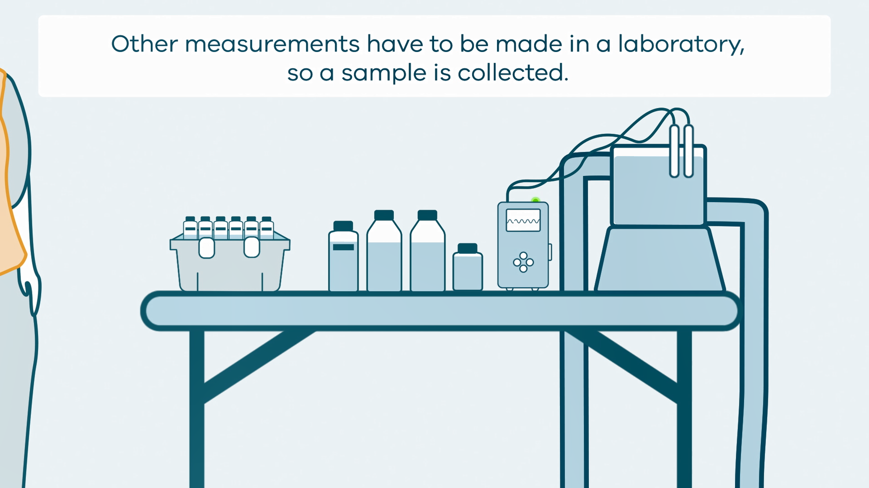
This animation shows how groundwater sampling is conducted. It is part of a series of Field Activity Technique Engagement Animations. The target audience are the communities that are impacted by GA's data acquisition activities. There is no sound or voice over. The 2D animation includes a simplified view of what groundwater sampling equipment looks like, what the equipment measures and how scientists use the data.
-
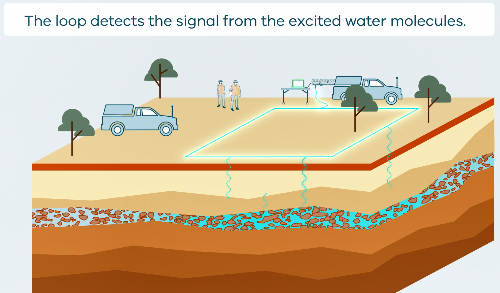
This animation shows how Surface Magnetic Resonance (SMR) Surveys are conducted. It is part of a series of Field Activity Technique Engagement Animations. The target audience are the communities that are impacted by GA's data acquisition activities. There is no sound or voice over. The 2D animation includes a simplified view of what SMR equipment looks like, what the equipment measures and how scientists use the data.
-
This compilation data release is a selection of remotely sensed imagery used in the Exploring for the Future (EFTF) East Kimberley Groundwater Project. Datasets include: • Mosaic 5 m digital elevation model (DEM) with shaded relief • Normalised Difference Vegetation Index (NDVI) percentiles • Tasselled Cap exceedance summaries • Normalised Difference Moisture Index (NDMI) • Normalised Difference Wetness Index (NDWI) The 5m spatial resolution digital elevation model with associated shaded relief image were derived from the East Kimberley 2017 LiDAR survey (Geoscience Australia, 2019b). The Normalised Difference Vegetation Index (NDVI) percentiles include 20th, 50th, and 80th for dry seasons (April to October) 1987 to 2018 and were derived from the Landsat 5,7 and 8 data stored in Digital Earth Australia (see Geoscience Australia, 2019a). Tasselled Cap Exceedance Summary include brightness, greenness and wetness as a composite image and were also derived from the Landsat data. These surface reflectance products can be used to highlight vegetation characteristics such as wetness and greenness, and land cover. The Normalised Difference Moisture Index (NDMI) and Normalised Difference Water Index (NDWI) were derived from the Sentinel-2 satellite imagery. These datasets have been classified and visually enhanced to detect vegetation moisture stress or water-logging and show distribution of moisture. For example, positive NDWI values indicate waterlogged areas while waterbodies typically correspond with values greater than 0.2. Waterlogged areas also correspond to NDMI values of 0.2 to 0.4. Geoscience Australia, 2019a. Earth Observation Archive. Geoscience Australia, Canberra. http://dx.doi.org/10.4225/25/57D9DCA3910CD Geoscience Australia, 2019b. Kimberley East - LiDAR data. Geoscience Australia, Canberra. C7FDA017-80B2-4F98-8147-4D3E4DF595A2 https://pid.geoscience.gov.au/dataset/ga/129985
-
<p>This package contains airborne electromagnetic (AEM) data from the "SkyTEM helicopter EM Howard East region" survey which was flown over Howard East region, Northern Territory during July - August 2017. The area is comprised of 2073.6 line kilometres in total. <p>The aim of the survey is to provide at a reconnaissance scale: <p>a) trends in regolith thickness and variability <p>b) variations in bedrock conductivity <p>c) conductivity of key bedrock (lithology related) conductive units under cover <p>d) the groundwater resource potential of the region <p>This report lists the SkyTEM system information and specifications relevant for this survey, and describes the processing carried out on the data. <p>Geoscience Australia commissioned the survey as part of the Exploring for the Future (EFTF) program. The EFTF program is led by Geoscience Australia (GA), in collaboration with the Geological Surveys of the Northern Territory, Queensland, South Australia and Western Australia, and is investigating the potential mineral, energy and groundwater resources in northern Australia and South Australia. The EFTF is a four-year $100.5 million investment by the Australian Government in driving the next generation of resource discoveries in northern Australia, boosting economic development across this region (https://www.ga.gov.au/eftf).
-
This brief report updates the ‘Two-part Seabed Geomorphology classification scheme’ of Dove et al. (2016) and presents a new glossary (Part 1) of Seabed Morphology features. This Morphology glossary is intended to provide marine scientists with an accurate and robust way to characterise the seabed. Each glossary entry includes a feature definition and a representative schematic diagram to support clear and consistent classification. Feature terms and definitions are primarily drawn from the IHO guide for undersea feature names, which are herein modified and augmented with additional terms to ensure the final feature catalogue and glossary encompasses the diversity of morphologies observed at the seabed, while also minimising duplication and/or ambiguity. This updated classification system and new glossary are the result of a collaboration between marine geoscientists from marine mapping programmes/networks in Norway (MAREANO), Ireland (INFOMAR), UK (MAREMAP), and Australia (Geoscience Australia) (MIM-GA). A subsequent report will present the (Part 2) Geomorphology feature glossary. <b>Citation:</b> Dove, Dayton, Nanson, Rachel, Bjarnadóttir, Lilja R., Guinan, Janine, Gafeira, Joana, Post, Alix, Dolan, Margaret F.J., Stewart, Heather, Arosio, Riccardo, & Scott, Gill. (2020). <i>A two-part Seabed Geomorphology classification scheme (v.2); Part 1: Morphology Features Glossary.</i> Zenodo. https://doi.org/10.5281/zenodo.4071939
-
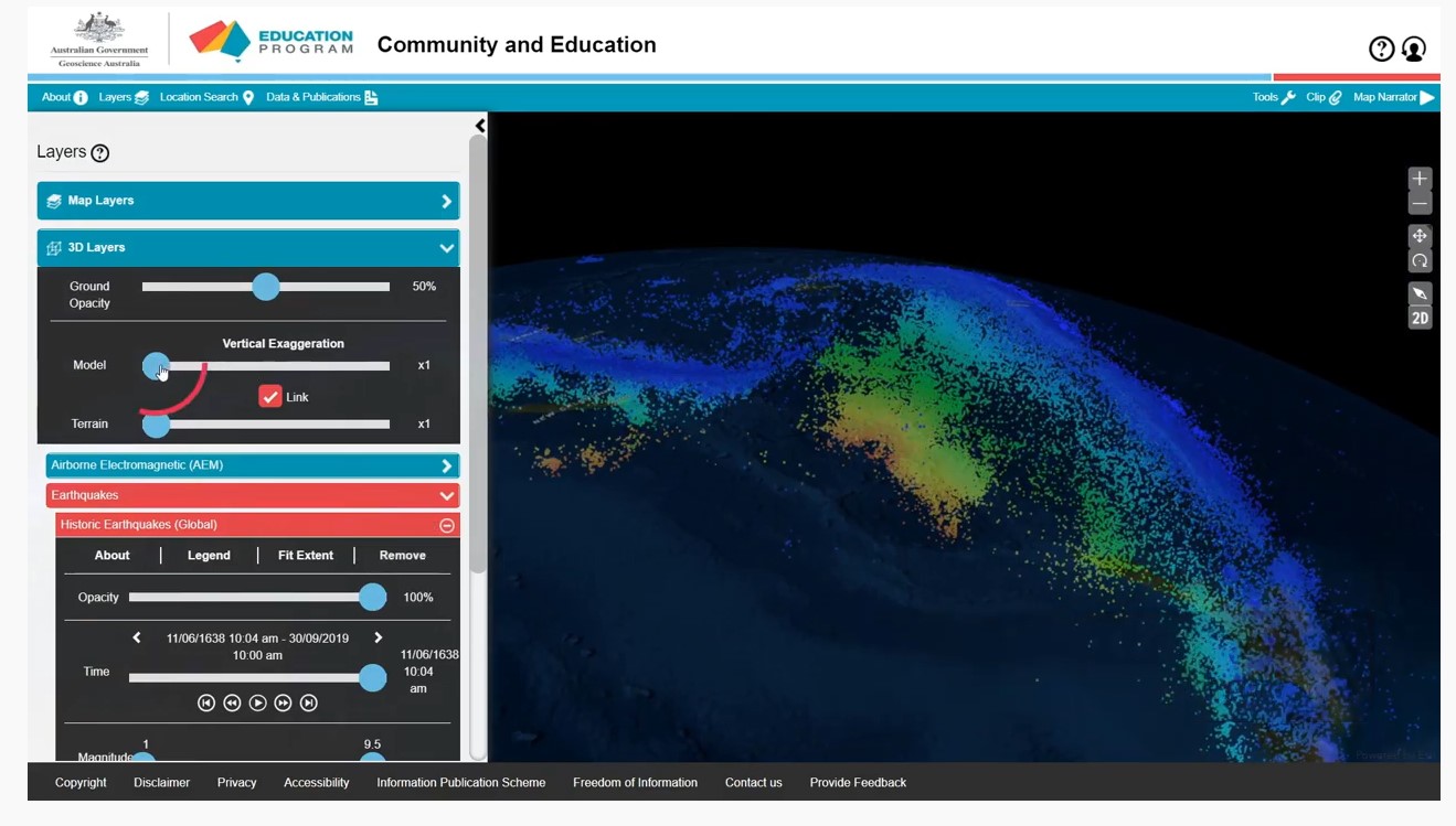
A series of short video clips illustrating how to use the Community and Education Data Portal (https://portal.ga.gov.au/persona/education). The Community and Education data portal is one of many data delivery portals available from Geoscience Australia, giving users access to a wealth of useful data and tools. It has been designed specifically for non-technical users, so that general community members, including educators, can access themed surface and subsurface datasets or images with enhanced capabilities including 3D visualisation, and online analysis tools. The User Guide Video complements the help menu in the portal. The User guide is broken into a series of topics 1. Introduction 2. Toolbar 3. Map layers 4. Multiple Layers 5. Background Layers and Sharing 6. 3D Layers 7. Tools 8. Custom Layers The step by step guides were produced by James Cropper.
-
Our knowledge of life at the Antarctic sea-bed has increased in the past decades with increasing ship-based surveys and monitoring sites, new technologies and data sharing. However, seafloor habitats and their communities exhibit high spatial variability and heterogeneity that limits our ability to assess the state of the Southern Ocean benthos on larger scales. The seafloor communities that inhabit the Antarctic shelf are often diversity hotspots. These habitats are important in the generation of ‘blue carbon’ and habitat for commercial fish species, for this reason we focus on these habitats. Many Southern Ocean seafloor habitats and their communities seem to be especially vulnerable to certain drivers of change including increasing ocean temperatures, iceberg scour, sea-ice melt, ocean acidification, fishing pressures, pollution and non-indigenous species. Some of the most vulnerable areas include those experiencing rapid regional warming and increased iceberg-scouring e.g. the West Antarctic Peninsula; where human activities and environmental conditions increase the potential for the establishment of non-indigenous species e.g. sub-Antarctic islands and tourist destinations and areas with fishing activities e.g. around South Georgia, Heard and MacDonald Islands. Vulnerable species include calcifying species susceptible to increasing ocean acidity as well as slow-growing habitat forming species that can be damaged by fishing gears e.g. sponges, bryozoan and coral species. Management regimes can protect seafloor habitats and key species from fishing activities but only if they consider specific traits, such as longevity, food availability, their physiological adaptation and rare or common occurrences. Ecosystem-based management practices and long-term protected areas may be the most effective in the preservation of vulnerable seafloor habitats. However, action is needed to reduce carbon emissions to limit the impact of increasing ocean temperatures and ocean acidification. We focus on outlining seafloor responses to drivers of change observed to date and projections for the future. We discuss the need for action to preserve seafloor habitats under climate change and fishing pressures. <b>Citation:</b> Brasier MJ, Barnes D, Bax N, Brandt A, Christianson AB, Constable AJ, Downey R, Figuerola B, Griffiths H, Gutt J, Lockhart S, Morley SA, Post AL, Van de Putte A, Saeedi H, Stark JS, Sumner M and Waller CL (2021) Responses of Southern Ocean Seafloor Habitats and Communities to Global and Local Drivers of Change. <i>Front. Mar. Sci.</i> 8:622721. doi: 10.3389/fmars.2021.622721
-
The continental slope seaward of the Totten Glacier and Sabrina Coast displays a suite of submarine canyons separated by ridges. The ridges show a range of morphological features that indicate they form by accretion of pelagic and hemipelagic sediment which can be remobilised by mass movement. The study area can be divided into two areas with distinct geomorphological features. Canyons in the eastern part of the study area have concave thalwegs and are linked to the shelf edge and upper slope and show signs of erosion and deposition along their beds suggesting cycles of activity controlled by climate cycles. The major canyon in the western part of the area has a convex thalweg. It is likely fed predominantly by mass movement from the flanks of the adjacent ridges with less input sediment from the shelf edge. The ridges between canyons in the Eastern part of the study area are asymmetric with crests close to the west bank of adjacent canyons and are mostly formed by westward advection of fine sediment lofted from turbidity currents and deposition of pelagic sediment. The ridges in the western part of the study area are more likely fully contourites, formed by accretion of suspended sediment with their associated canyons fed by flows derived predominantly from slumping on the adjacent ridge flanks. Canyons and ridges in the eastern part of the study area lie to the east of the Totten Glacier and are seaward of small ice drainage basins feeding the Moscow University Ice Shelf. Ridges and canyons in the western part of area formed from sediment transported along the margin and from detritus originating from the Totten Glacier. Higher sediment supply produced larger, shallower ridges that interact with ocean currents and coincide with a long-lived depocenter. The overall geomorphology of the Sabrina Coast slope is part of a continuum of mixed contourite-turbidite systems identified on the Antarctic margin. These ridges are thus prime locations to sample for sedimentary records of the Totten Glacier’s interaction with the adjacent ocean. <b>Citation:</b> E. O'Brien, A.L. Post, S. Edwards, T. Martin, A. Caburlotto, F. Donda, G. Leitchenkov, R. Romeo, M. Duffy, D. Evangelinos, L. Holder, A. Leventer, A. López-Quirós, B.N. Opdyke, L.K. Armand, Continental slope and rise geomorphology seaward of the Totten Glacier, East Antarctica (112°E-122°E), <i>Marine Geology</i>, Volume 427, 2020, 106221, ISSN 0025-3227, https://doi.org/10.1016/j.margeo.2020.1062
-
This collection includes information regarding the location and design of Australian onshore and offshore boreholes, where boreholes are defined as the generalized term for any narrow shaft drilled in the ground, either vertically or horizontally. In this context, boreholes include: Mineral Drillholes, Petroleum Wells and Water Bores along with a variety of others types, but does not include Costean, Trench or Pit. <b>Value: </b> Information related to the boreholes described in this collection have the potential to support geological investigations and assessment of a variety of resources. <b>Scope: </b>Selected open file boreholes Australian boreholes located onshore and offshore
-
This Port Phillip-Westernport Basin dataset contains descriptive attribute information for the areas bounded by the relevant spatial groundwater feature in the associated Hydrogeology Index map. Descriptive topics are grouped into the following themes: Location and administration; Demographics; Physical geography; Surface water; Geology; Hydrogeology; Groundwater; Groundwater management and use; Environment; Land use and industry types; and Scientific stimulus. The Port Phillip and Westernport basins are small, shallow sedimentary basins located in south-central Victoria, formed during the Late Cretaceous rifting of Australia and Antarctica. They share similar stratigraphy with nearby basins. The Port Phillip Basin is bounded by the Selwyn and Rowsley Faults to the east and west, while the Heath Hill Fault marks the eastern boundary of the Westernport Basin. Both basins have pre-Cenozoic basement rocks comprising folded and faulted Paleozoic metasedimentary rocks and granites from the Lachlan Fold Belt. The Port Phillip Basin's stratigraphy includes Maastrichtian to Cenozoic sedimentary units with intercalated volcanic rocks. The main depocentres are the Sorrento Graben, Ballan Graben/Lal Lal Trough, and Parwan Trough. Notable formations are the Yaloak and Werribee formations, with coal-bearing strata and marine sediments. The Westernport Basin has coastal sediments and volcanic deposits from Paleocene to Holocene. It experienced marine transgressions and regressions due to sea-level fluctuations. Fault movements in the late Pliocene and early Pleistocene formed a fault-bounded depression centered on the Koo Wee Rup Plain. The main units are the Childers Formation, Older Volcanics, Yallock Formation, Sherwood Marl, and Baxter Sandstone. Both basins have Quaternary sediments, including Pleistocene eolian sand sequences, Holocene alluvial and paludal clays, and fluvial sediments in valleys and palaeovalleys. The Port Phillip Basin contains distinct phases of terrestrial and marine deposition, while the Westernport Basin has Eocene volcanism and marine sediments. These basins are important geological features in the region, with various formations representing millions of years of geological history.