Borehole
Type of resources
Keywords
Publication year
Service types
Topics
-
<b>Legacy service Retired 29/11/2022 IMPORTANT NOTICE: </b>This web service has been deprecated. The Australian Onshore and Offshore Boreholes OGC service at https://services.ga.gov.au/gis/boreholes/ows should now be used for accessing Geoscience Australia borehole data. This is an Open Geospatial Consortium (OGC) web service providing access to Australian onshore and offshore borehole data. This web service is intended to complement the borehole GeoSciML-Portrayal v4.0 web service, providing access to the data in a simple, non-standardised structure. The borehole data includes Mineral Drillholes, Petroleum Wells and Water Bores along with a variety of others types. The dataset has been restricted to onshore and offshore Australian boreholes, and bores that have the potential to support geological investigations and assessment of a variety of resources.
-
This report presents a stratigraphic review of some key boreholes across the Jurassic-Cretaceous Eromanga, Surat and Carpentaria basins that form the groundwater Great Artesian Basin (GAB), as well as across the overlying Cenozoic Lake Eyre Basin (LEB), completed during the National Groundwater Systems (NGS) Project. The NGS Project is part of Exploring for the Future (EFTF)—an eight year, $225 million Australian Government funded geoscience data and information acquisition program focused on better understanding the potential mineral, energy and groundwater resources across Australia. The study presented here builds on previous work (Norton & Rollet, 2022a) undertaken as part of the ‘Assessing the Status of Groundwater in the Great Artesian Basin’ Project, commissioned by the Australian Government through the National Water Infrastructure Fund – Expansion. Although not intended to be a major re-interpretation of existing data, this stratigraphy review updates stratigraphic picks where necessary to obtain a consistent interpretation across the study area, based on the refined geological and hydrostratigraphical framework developed through this project. Problems and inconsistencies in the input data or current interpretations have been highlighted to suggest where further studies or investigations may be useful. This study includes Phase 2 of the National Groundwater Systems Project, which was undertaken by Catherine Jane Norton in collaboration with Geoscience Australia; and compiled, processed and correlated a variety of borehole log data to review the stratigraphy and improve the understanding of distribution and characteristics of Jurassic and Cretaceous sediments across the Eromanga and Surat basins and overlying LEB. To complement the previous 322 key boreholes compiled in Phase 1 (Norton & Rollet, 2022) additional stratigraphic correlations have been made between geological units of similar age (constrained using palynological data) from 706 key boreholes along 35 regional transects across the GAB and from 406 key boreholes along 20 regional transects across the central LEB. Also included in this study is Phase 3 in-fill work of four additional transects, extending the study further south in New South Wales, to tie in to the Cenozoic of the Murray Basin. This later phase 3 of the project also included a review and quality control of approximately 2,572 central LEB boreholes, and the addition of 278 boreholes in the GAB in southern Queensland and New South Wales. Phase 3 also expanded on the results used for mapping regional sand/shale ratios that began in the previous phase (Evans et al., 2020; Norton & Rollet, 2022a). Normalised Gamma Ray (GR) calculations have now been made for 1,778 LEB boreholes and 676 GAB boreholes spanning the entire sequence from the surface, through the Cenozoic and down to the base Jurassic unconformity. The previous phase, mentioned above, concentrated on either just the LEB or the GAB intervals from Cadna-owie Formation to base Jurassic. An additional 17 transects in the LEB and 27 transects in the GAB were created to visualise the lithological variation. The distribution of generalised sand/shale ratios are used to estimate the thickness of sand and shale in different formations, with implications for formation porosity and the hydraulic properties of aquifers and aquitards. This study fills data gaps identified in the previous study (Norton & Rollet, 2022) and refines the regional distribution of lithological heterogeneity in each hydrogeological unit, contributing to an improved understanding of connectivity within and between aquifers. The datasets compiled and examined in this study are in Appendix A. Attempts were made to standardise lithostratigraphic units, which are currently described using varying nomenclature, to produce a single chronostratigraphic chart across the entirety of the GAB and LEB basins. The main stratigraphic correlation infill in the GAB and LEB regions focused on: • The transition between the Eromanga and Surat basins in New South Wales and the tie-in to existing transects in Queensland and South Australia, • The Eromanga Basin in South Australia and Queensland and the tie-in to Phase 1 transects, • The central Eromanga Basin and Frome Embayment areas, extending the GAB units to the overlying Lake Eyre Basin stratigraphy to better assess potential connectivity between these basins, • The transition between the Lake Eyre and Murray Basins in the Upper Darling Floodplain (UDF) area in New South Wales and the tie-in to Phase 1 transects in New South Wales. This report and associated data package provide a data compilation on 706 and 278 key boreholes in the Surat and Eromanga basins respectively, to assist in updating the geological framework for the GAB and LEB. Recommendations are provided for further studies to continue refining the understanding of the stratigraphy in the Great Artesian and Lake Eyre basins.
-
This service provides Estimates of Geological and Geophysical Surfaces (EGGS). The data comes from cover thickness models based on magnetic, airborne electromagnetic and borehole measurements of the depth of stratigraphic and chronostratigraphic surfaces and boundaries.
-
A collection of geological samples associated with drilling activities and submitted by companies under the Offshore Petroleum and Greenhouse Gas Storage Act 2006 (OPGGSA) and previous legislations that required petroleum data to be submitted to the National Offshore Petroleum Data and Core Repository (NOPDCR). The collection also contains cores and cuttings samples acquired by Geoscience Australia and its predecessor BMR, other government agencies and institutions from around Australia. <b>Value: </b>Information related to the subsurface that have the potential to support geological investigations and assessment of a variety of resources. <b>Direct access</b> to petroleum mining sample information is available on National Offshore Petroleum Information Management System (NOPIMS) platform (https://www.ga.gov.au/nopims) via the Core Library tab. <b>Request to access</b> those samples can also be made via the form available on NOPIMS. https://nopims.dmp.wa.gov.au/Nopims/RequestForms/CoreCuttingsAccess/CoreCuttingsAccess
-
Geoscience Australia, in collaboration with the Geological Survey of New South Wales and the Geological Survey of Queensland, have been collecting precompetitive geoscience data in the southern Thomson Orogen as part of the Southern Thomson project. This Project is designed to encourage industry investment in this poorly understood area, and spark interest by explorers to potentially discover a new minerals province. A stratigraphic drilling program was established to: 1. Develop baseline geologic constraints 2. Improve the understanding of basement geology 3. Better understand the potential for mineralisation. In the frame of this project, hyperspectral data have been collected from mud rotary drill chips and diamond drill cores penetrating the Mesozoic Eromanga Basin into basement felsic igneous, clastic sedimentary and metasedimentary rocks of the southern Thomson Orogen. Geoscience Australia requested assistance from CSIRO in performing quality assurance (QA) by reprocessing and reinterpreting hyperspectral data collected from 14 boreholes to inform the components of the stratigraphic drilling program. This report outlines the results of CSIRO’s reprocessing of the hyperspectral drill core data, which consisted of the following: 1. Quality Assurance (QA) on the data 2. Identification of visible to near infrared, shortwave-infrared and thermal infrared active mineral species 3. Identification of mineral assemblages 4. Comparison of mineralogy with other available geoscience data, such as geochemistry, where available.
-
<b> Legacy service retired 29/11/2022</b> This is an Open Geospatial Consortium (OGC) web service providing access to Australian onshore and offshore borehole data conforming to the GeoSciML version 4.0 specification. The borehole data includes Mineral Drillholes, Petroleum Wells and Water Bores along with a variety of others types. The dataset has been restricted to onshore and offshore Australian boreholes, and bores that have the potential to support geological investigations and assessment of a variety of resources.
-
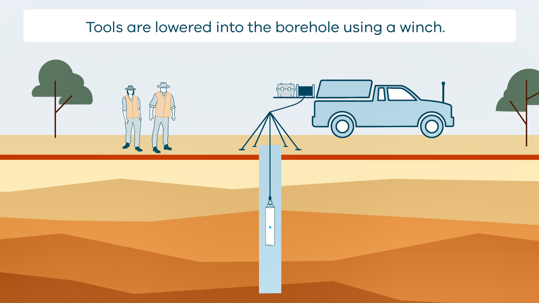
This animation shows how borehole geophysical surveys are conducted. It is part of a series of Field Activity Technique Engagement Animations. The target audience are the communities that are impacted by GA's data acquisition activities. There is no sound or voice over. The 2D animation includes a simplified view of what borehole geophysics equipment looks like, what the equipment measures and how scientists use the data.
-
Geoscience Australia’s Exploring for the Future (EFTF) program provides precompetitive information to inform decision-making by government, community and industry on the sustainable development of Australia's mineral, energy and groundwater resources. By gathering, analysing and interpreting new and existing precompetitive geoscience data and knowledge, we are building a national picture of Australia’s geology and resource potential. This leads to a strong economy, resilient society and sustainable environment for the benefit of all Australians. This includes supporting Australia’s transition to a low emissions economy, strong resources and agriculture sectors, and economic opportunities and social benefits for Australia’s regional and remote communities. The Exploring for the Future program, which commenced in 2016, is an eight year, $225m investment by the Australian Government. Further detail is available at http://www.ga.gov.au/eftf. The National Groundwater Systems (NGS) project, is part of the Australian Government’s Exploring for the Future (EFTF) program, led by Geoscience Australia (https://www.eftf.ga.gov.au/national-groundwater-systems), to improve understanding of Australia’s groundwater resources to better support responsible groundwater management and secure groundwater resources into the future. The project is developing new national data coverages to constrain groundwater systems, develop a new map of Australian groundwater systems and improve data standards and workflows of groundwater assessment to populate a consistent data discovery tool and web-based mapping portal to visualise, analyse and download hydrogeological information. While our hydrogeological conceptual understanding of Australian groundwater systems continues to grow in each State and Territory jurisdiction, in addition to legacy data and knowledge from the 1970s, new information provided by recent studies in various parts of Australia highlights the level of geological complexity and spatial variability in stratigraphic and hydrostratigraphic units across the continent. We recognise the need to standardise individual datasets, such as the location and elevation of boreholes recorded in different datasets from various sources, as well as the depth and nomenclature variations of stratigraphic picks interpreted across jurisdictions to map such geological complexity in a consistent, continent-wide stratigraphic framework that can support effective long-term management of water resources and integrated resource assessments. This stratigraphic units data compilation at a continental scale forms a single point of truth for basic borehole data including 47 data sources with 1 802 798 formation picks filtered to 1 001 851 unique preferred records from 171 367 boreholes. This data compilation provides a framework to interpret various borehole datasets consistently, and can then be used in a 3D domain as an input to improve the 3D aquifer geometry and the lateral variation and connectivity in hydrostratigraphic units across Australia. The reliability of each data source is weighted to use preferentially the most confident interpretation. Stratigraphic units are standardised to the Australian Stratigraphic Units Database (ASUD) nomenclature (https://asud.ga.gov.au/search-stratigraphic-units) and assigned the corresponding ASUD code to update the information more efficiently when needed. This dataset will need to be updated as information grows and is being revised over time. This dataset provides: 1. ABSUC_v1 Australian stratigraphic unit compilation dataset (ABSUC) 2. ABSUC_v1_TOP A subset of preferred top picks from the ABSUC_v1 dataset 3. ABSUC_v1_BASE A subset of preferred base picks from the ABSUC_v1 dataset 4. ABSUC_BOREHOLE_v1 ABSUC Borehole collar dataset 5. ASUD_2023 A subset of the Australia Stratigraphic Units Database (ASUD) This consistent stratigraphic units compilation has been used to refine the Great Artesian Basin geological and hydrogeological surfaces in this region and will support the mapping of other regional groundwater systems and other resources across the continent. It can also be used to map regional geology consistently for integrated resource assessments.
-
The Geoscience Australia Rock Properties database stores the result measurements of scalar and vector petrophysical properties of rock and regolith specimens and hydrogeological data. Oracle database and Open Geospatial Consortium (OGC) web services. Links to Samples, Field Sites, Boreholes. <b>Value:</b> Essential for relating geophysical measurements to geology and hydrogeology and thereby constraining geological, geophysical and groundwater models of the Earth <b>Scope:</b> Data are sourced from all states and territories of Australia
-
<b>IMPORTANT NOTICE:</b> This web service has been deprecated. The Australian Onshore and Offshore Boreholes OGC service at https://services.ga.gov.au/gis/boreholes/ows should now be used for accessing Geoscience Australia borehole data. This is an Open Geospatial Consortium (OGC) web service providing access to a subset of Australian geoscience samples data held by Geoscience Australia. The subset currently relates specifically to Australian Boreholes.