BUILT ENVIRONMENT AND DESIGN
Type of resources
Keywords
Publication year
Topics
-
NEXIS (National Exposure Information System) Residential Dwelling Density is a set of four raster layers representing the density of residential dwellings across Australia at different scales and resolutions. Resolutions include 2km, 1km, 500m and 100m. The Australian Bureau of Statistics (ABS) defines dwelling units as self-contained suites of rooms including cooking and bathing facilities and intended for long-term residential use. Such dwelling units include houses-detached buildings used for long-term residential purposes-and other dwellings including flats. This product is based on NEXIS version 13 (2022) data.
-
Knowledge of the nature of buildings within CBD areas is fundamental to a broad range of decision making processes, including planning, emergency management and the mitigation of the impact of natural hazards. To support these activities, Geoscience Australia has developed a building information system called the National Exposure Information System (NEXIS) which provides information on buildings across Australia. Most of the building level information in NEXIS is statistically derived, but efforts are being made to include more detailed information on the nature of individual buildings, particularly in CBD areas. This is being achieved in the Gold Coast through field survey work.
-
Millions of data points have been acquired or compiled through both phases of the Exploring for the Future (EFTF) program at Geoscience Australia (GA). This data that graces the EFTF Portal and appears in many publications has another home within specialist databases designed and built to house the specific data that GA collects. One such database is HYDROCHEM, which was implemented as part of the Enhanced Data Delivery (EDD) and National Groundwater Systems (NGS) projects. HYDROCHEM hosts 190,097 rows of groundwater, surface water and rainfall water chemistry analyses. This data was either previously hosted in the GNDWATER database, or compiled from legacy data stores. The redevelopment of GNDWATER to HYDROCHEM saw the de-duplication and updating of sample and site-specific metadata into other GA databases, such as SAMPLES, BOREHOLES and FIELDSITES. The redevelopment also added additional constraints to the database, including minimum metadata requirements, constrained look-up tables for units of measure, laboratory, method, filter sizes, standards and uncertainty types. Other features include minimum and maximum values for particular analytes and delivery of the data in standardised GA-preferred units of measure.
-
<p><b>Please Note: Restricted - cannot be made public as it contains sensitive information</b> <p>Record of GA exposure survey in the town of York, WA
-
Knowledge of the nature of buildings within CBD areas is fundamental to a broad range of decision making processes, including planning, emergency management and the mitigation of the impact of natural hazards. To support these activities, Geoscience Australia has developed a building information system called the National Exposure Information System (NEXIS) which provides information on buildings across Australia. Most of the building level information in NEXIS is statistically derived, but efforts are being made to include more detailed information on the nature of individual buildings, particularly in CBD areas. This is being achieved in Hobart through field survey work.
-
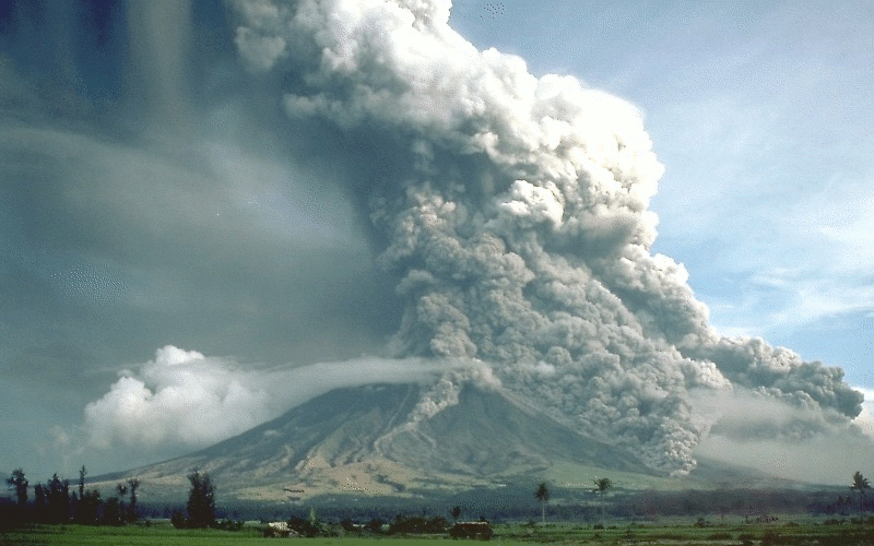
Activity for secondary and senior secondary students examining a hypothetical city and its vulnerability to volcanic hazard risk. Includes background information for teachers, PowerPoint presentation, student activity sheet and worked answers.
-
<div>Global steel demand is forecast to grow in the coming decades with continued development across Asia and Africa. Over the same period, the International Energy Agency suggests that the carbon intensity of steel production will need to decrease rapidly to align with projected pathways to net zero emissions by 2050. Balancing these competing priorities is a challenge that could shift global steelmaking business models. With abundant resources of both iron ore and metallurgical coal, Australia has benefited significantly from traditional steelmaking value chains. In the face of potential disruption, how should Australia navigate the challenges and opportunities accompanying the transition to ’green’ steel? How can geoscience help to identify and leverage Australia’s specific advantages? </div><div><br></div><div>The Green Steel Economic Fairways Mapper is a free, online tool that models the costs of hydrogen-based green ironmaking and steelmaking and maps how these costs vary across Australia. Developed through collaboration between Geoscience Australia and Monash University, it represents a novel approach to model multiple interconnected resource facilities. Following the Economic Fairways approach, the Mapper combines large-scale infrastructure and geoscience datasets to provide a high-level, geospatial analysis of the economic viability of hypothetical green steel projects. In doing so it creates a new capability within Australia—filling the void before the detail and expense of feasibility studies—to understand the broad contours of the decarbonization challenge, and to inform early-stage decision making in the pursuit of low-carbon steel. In this seminar, we introduce the Green Steel Economic Fairways Mapper, demonstrate its capabilities, and discuss some of the insights it reveals. </div>
-
Knowledge of the nature of buildings within CBD areas is fundamental to a broad range of decision making processes, including planning, emergency management and the mitigation of the impact of natural hazards. To support these activities, Geoscience Australia has developed a building information system called the National Exposure Information System (NEXIS) which provides information on buildings across Australia. Most of the building level information in NEXIS is statistically derived, but efforts are being made to include more detailed information on the nature of individual buildings, particularly in CBD areas. This is being achieved in Brisbane through field survey work.
-
Knowledge of the nature of buildings within business precincts is fundamental to a broad range of decision making processes, including planning, emergency management and the mitigation of the impact of natural hazards. To support these activities, Geoscience Australia has developed a building information system called the National Exposure Information System (NEXIS) which provides information on buildings across Australia. Most of the building level information in NEXIS is statistically derived, but efforts are being made to include more detailed information on the nature of individual buildings, particularly in business districts. This is being achieved in Adelaide through field survey work.
-
Knowledge of the nature of buildings within business precincts is fundamental to a broad range of decision making processes, including planning, emergency management and the mitigation of the impact of natural hazards. To support these activities, Geoscience Australia has developed a building information system called the National Exposure Information System (NEXIS) which provides information on buildings across Australia. Most of the building level information in NEXIS is statistically derived, but efforts are being made to include more detailed information on the nature of individual buildings, particularly in business districts. This is being achieved in Sydney through field survey work.