Resource geoscience
Type of resources
Keywords
Publication year
Topics
-
<div>Convergent margins are a hallmark feature of modern style plate tectonics. One expression of their operation is metallogenesis, which therefore may yield important insights into secular changes in styles of convergence and subduction. A global comparison of metallogenesis along convergent margins of over 20 well-endowed provinces indicates a consistent and systematic progression of mineral deposit types. We term this progression the convergent margin metallogenic cycle (CMMC). </div><div> This CMMC mirrors convergent margin evolution. Each metallogenic cycle begins with the formation of porphyry copper deposits and/or volcanic-hosted massive sulphide deposits, associated with arc construction and back arc basin formation, respectively. When the convergent margin transitions into contraction/orogenesis due to processes such as accretion, flattening of subduction, or continent-continent collision, mineral deposits that form include orogenic gold and structurally hosted base metal deposits. Post-contractional extension is marked by the formation of intrusion related rare metal (tin, tungsten, molybdenum) and gold deposits, pegmatites, and alkaline porphyry copper deposits, closing the CMMC. </div><div> Our analysis of the metallogenic record reveals that prior to ~3 Ga, metallogenesis is episodic and non-systematic, with CMMCs not recognised. From the mid- to late Mesoarchean onwards, CMMCs are observed in all provinces analysed, and display systematic trends through time: the Meso- to Neoarchean metallogenic provinces are characterized by a single metallogenic cycle, whereas in the Paleo- to Mesoproterozoic provinces, both single and multiple metallogenic cycles occur. From the middle Neoproterozoic onwards multiple metallogenic cycles are the rule. This evolution is accompanied by an increase in the duration of metallogenesis, ranging from ~100 to 180 million years in the Meso- to Neoarchean and 220 to more than 400 million years since the late Proterozoic. </div><div> We interpret these trends to reflect secular changes in tectonic processes and Earth evolution. The emergence of CMMCs from ~3 Ga provides independent evidence for the operation of some early form of subduction since this time. The fact that CMMCs are recognized in all provinces of mid-Meso- to Neoarchean age suggests that subduction was the common <em>modus operandi</em> rather than an exception. The first appearance of multiple metallogenic cycles in the Paleoproterozoic may reflect the strengthening of cratonic margins by tectonothermal maturation since formation in the Archean. Long-lived metallogenesis and multiple metallogenic cycles in the Neoproterozoic and Phanerozoic are linked to deep-slab break-off, or modern, subduction in which the internal strength of the subducting slab allows maintenance of slab coherency. </div><div> This Abstract was submitted/presented to the 2023 6th International Archean Symposium (6IAS) 25 - 27 July (https://6ias.org/)
-
<div>Lateral variation in maturity of potential Devonian source rocks in the Adavale Basin has been investigated using nine 1D burial, thermal and petroleum generation history models, constructed using existing open file data. These models provide an estimate of the hydrocarbon generation potential of the basin. Total organic carbon (TOC) content and pyrolysis data indicate that the Log Creek Formation, Bury Limestone and shale units of the Buckabie Formation have the most potential as source rocks. The Log Creek Formation and the Bury Limestone are the most likely targets for unconventional gas exploration.</div><div>The models were constructed using geological information from well completion reports to assign formation tops and stratigraphic ages, and then forward model the evolution of geophysical parameters. The rock parameters, including facies, temperature, organic geochemistry and petrology, were used to investigate source rock quality, maturity and kerogen type. Suitable boundary conditions were assigned for paleo-heat flow, paleo-surface temperature and paleo-water depth. The resulting models were calibrated using bottom hole temperature and measured vitrinite reflectance data.</div><div>The results correspond well with published heat flow predictions, although a few wells show possible localised heat effects that differ from the basin average. The models indicate that three major burial events contribute to the maturation of the Devonian source rocks, the first occurring from the Late Devonian to early Carboniferous during maximum deposition of the Adavale Basin, the second in the Late Triassic during maximum deposition of the Galilee Basin, and the third in the Late Cretaceous during maximum deposition of the Eromanga Basin. Generation in the southeastern area appears to have not been effected by the second and third burial events, with hydrocarbon generation only modelled during the Late Devonian to early Carboniferous event. This suggests that Galilee Basin deposition was not significant or was absent in this area. Any potential hydrocarbon accumulations could be trapped in Devonian sandstone, limestone and mudstone units, as well as overlying younger sediments of the Mesozoic Eromanga Basin. Migration of the expelled hydrocarbons may be restricted by overlying regional seals, such as the Wallumbilla Formation of the Eromanga Basin. Unconventional hydrocarbons are a likely target for exploration in the Adavale Basin, with potential for tight or shale gas from the Log Creek Formation and Bury Limestone in favourable areas.</div>
-
<div>Gas production from the Inner Otway Basin commenced in the early 2000s but the deep-water part of this basin remains an exploration frontier. Historically, the understanding of plays in this region were largely model driven and therefore the ground-truthing of depositional environments (DE) and gross depositional environments (GDE) are critical. This aspect has been investigated for the Sherbrook Supersequence (SS) by the integration of legacy wireline and core data, with regional 2D seismic facies mapping of new and reprocessed data from Geoscience Australia’s 2020 Otway Basin seismic program. Core observations were matched to wireline logs and seismic facies with resulting well based DE interpretations calibrated to seismic resolution Regional GDE intervals. Integration of well and seismic observations lead to the compilation of a basin-wide Regional GDE map for the Sherbrook SS. This GDE map indicates the distribution of Sherbrook SS play elements such as source rock, seal and reservoir, especially across the Deep Water Otway Basin where well data is sparse.</div> Published in The APPEA Journal 2023. <b>Citation:</b> Cubitt Chris, Abbott Steve, Bernardel George, Gunning Merrie-Ellen, Nguyen Duy, Nicholson Chris, Stoate Alan (2023) Cretaceous depositional environment interpretation of offshore Otway Basin cores and wireline logs; application to the generation of basin-scale gross depositional environment maps. <i>The APPEA Journal</i><b> 63</b>, S215-S220. https://doi.org/10.1071/AJ22090
-
<div>Geoscience Australia’s Onshore Basin Inventories project delivers a single point of reference and creates a standardised national basin inventory that provides a whole-of-basin catalogue of geology, petroleum systems, exploration status and data coverage of hydrocarbon-prone onshore Australian sedimentary basins. In addition to summarising the current state of knowledge within each basin, the onshore basin inventory reports identify critical science questions and key exploration uncertainties that may help inform future work program planning and decision making for both government and industry. Volume 1 of the inventory covers the McArthur, South Nicholson, Georgina, Wiso, Amadeus, Warburton, Cooper and Galilee basins and Volume 2 expands this list to include the Officer, Perth and onshore Canning basins. Under Geoscience Australia’s Exploring for the Future (EFTF) program, several new onshore basin inventory reports are being delivered. Upcoming releases include the Adavale Basin of southern Queensland, and a compilation report addressing Australia’s poorly understood Mesoproterozoic basins. These are supported by value-add products that address identified data gaps and evolve regional understanding of basin evolution and prospectivity, including petroleum systems modelling, seismic reprocessing and regional geochemical studies. The Onshore Basin Inventories project continues to provide scientific and strategic direction for pre-competitive data acquisition under the EFTF work program, guiding program planning and shaping post-acquisition analysis programs.</div>
-
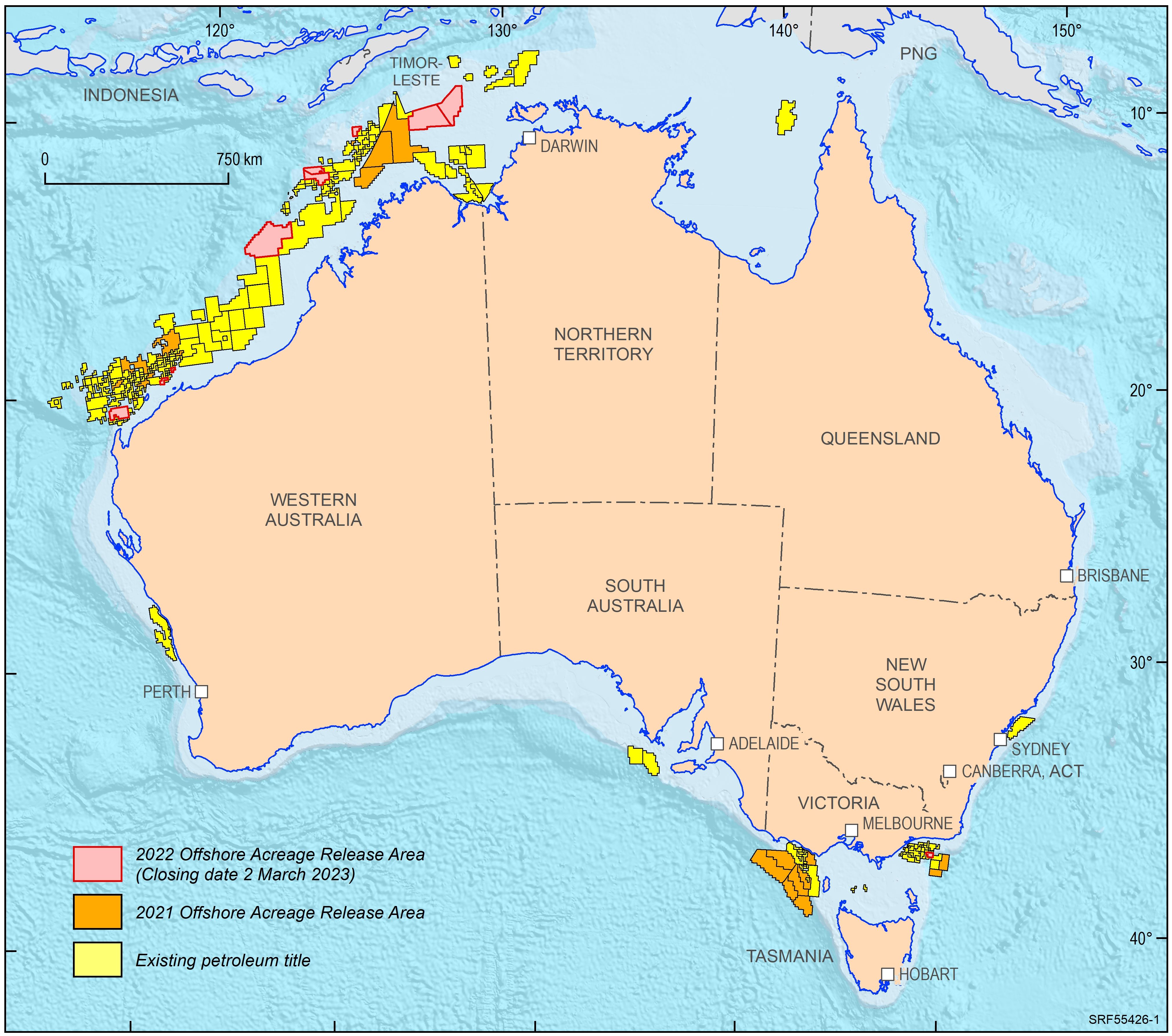
<div>In 2022, the Australian Government released ten offshore petroleum exploration areas. They are located in the Bonaparte Basin, Browse Basin, Northern Carnarvon Basin and Gippsland Basin. The areas highlight that producing provinces rather than data-poor regions are the preferred targets for exploration activities. In addition, the transition to low carbon energy resources, including opportunities for carbon capture and storage, has seen a diversification of energy companies’ portfolios. The Australian Government is supportive of the upstream energy industry, with natural gas seen as an important enabling energy resource commodity that supports the expansion of low emission technologies and related infrastructure. Most of the areas being offered for exploration in 2022 are likely to generate extra volumes of natural gas, both for domestic markets as well as securing feedstock for existing LNG export projects for the longer term. </div><div>Consistent with the approach of recent releases, only one period for work program bidding has been scheduled. The closing date for all bid submissions is 2 March 2023. </div><div>Geoscience Australia provides pre-competitive data and petroleum geological information in support of industry activities. Its petroleum geological studies aim to improve the understanding of the evolution of hydrocarbon-bearing basins at a regional scale and include a review of source rock and fluid occurrences, their geochemical characteristics, and petroleum systems modelling. Most recent examples include a sedimentological/stratigraphic study that investigates the depositional history of the southern Bonaparte Basin during the late Permian to Early Triassic evaluating the controls on reservoir facies development. A regional petroleum geological study of the Otway Basin, with a focus on the deeper water area and utilising newly industry acquired regional seismic data, provides new insights into the hydrocarbon prospectivity of this largely underexplored offshore part of the basin. Latest results of these studies were presented at this year’s APPEA conference. Large seismic and well data sets, submitted under the Offshore Petroleum and Greenhouse Gas Storage Act 2006 (OPGSSA) are made available through the National Offshore Petroleum Information Management System (NOPIMS). Additional data and petroleum related information can be accessed through Geoscience Australia’s data repository</div><div><br></div>
-
<div>As a resource to enhance exploration in the offshore Otway Basin, Geoscience Australia (GA) has produced a new well folio that extends the scope of a previous release by including 32 key wells from the central and southeast regions. This folio covers the areas from Normanby 1 on the Normanby Terrace, through the Shipwreck Trough and Nelson Sub-basin, to Whelk 1 in the south. The previous well composites included wireline logs for petrophysical analysis, interpreted lithology, organic geochemistry and organic petrology data, and well markers. This folio includes all of these attributes with the addition of core-based depositional environment (DE) and gross depositional environment (GDE) interval interpretations which were subsequently used to constrain wireline interpretation away from core control. The core/wireline lithological interpretation along with further seismic and biostratigraphic data informed well marker locations and enabled a better regional correlation across the basin. The folio provides the complementary datasets used to construct each well composite. Presented at the Australian Energy Producers (AEP) Conference & Exhibition (https://energyproducersconference.au/conference/)
-
<div>Maps showing the potential for iron oxide copper-gold (IOCG) mineral systems in Australia. Each of the mineral potential maps is a synthesis of four component layers (source of metals, fluids and ligands; energy sources and fluid flow drivers; fluid flow pathways and architecture; and ore depositional gradients). The model uses a hybrid data-driven and knowledge driven methodology to produce the final mineral potential map for the mineral system. An uncertainty map is provided in conjunction with the mineral potential maps that represents the availability of data coverage over Australia for the selected combination of input maps. Uncertainty values range between 0 and 1, with higher uncertainty values being located in areas where more input maps are missing data or have unknown values. The input maps and mineral deposits and occurrences used to generate the mineral potential map are provided along with an assessment criteria table which contains information on the map creation.</div>
-
<div>Geoscience Australia’s Exploring for the Future program provides precompetitive information to inform decision-making by government, community and industry on the sustainable development of Australia's mineral, energy and groundwater resources. By gathering, analysing and interpreting new and existing precompetitive geoscience data and knowledge, we are building a national picture of Australia’s geology and resource potential. This leads to a strong economy, resilient society and sustainable environment for the benefit of all Australians. This includes supporting Australia’s transition to net zero emissions, strong, sustainable resources and agriculture sectors, and economic opportunities and social benefits for Australia’s regional and remote communities. The Exploring for the Future (EFTF) program, which commenced in 2016, is an eight year, $225m investment by the Australian Government. </div><div><br></div><div>As part of the EFTF Program, Geoscience has completed a multi-disciplinary study to investigate the energy resource potential of selected onshore basins within central Australia under the Australia’s Future Energy Resources (AFER) Project. The AFER Project has adapted the conventional hydrocarbon play-based exploration workflow, developed by the petroleum industry over several decades, to develop a similar approach for assessing unconventional hydrocarbon resource potential and CO2 geological storage prospectivity. Play-based exploration is a method of building and leveraging an understanding of a basin and its sediment-hosted resources by systematically evaluating a series of play intervals using the best available geological data and models. Each play interval represents a regionally significant reservoir/aquifer for one or more resources (e.g. hydrocarbons, groundwater, CO2 storage intervals) often with an associated seal/aquitard. Various ‘risk elements’ that are essential for a resource to exist can be mapped and qualified with a probability of geological success. These risk elements are then spatially integrated (stacked) to generate common risk segment (CRS) or ‘heat’ maps for each play interval that indicate areas of relatively high prospectivity versus relatively low prospectivity. Geological risk elements are evaluated using post-drill analysis of well control points, and geological maps generated from basin studies.</div><div><br></div><div>Common risk segment mapping, supported by post-drill analysis, has been undertaken by the AFER Project using the GIS-Pax Player Software, and assigned a geological probability of success (POS) using a ‘split risking’ system that involves assessing: </div><div>· Pg play, which is the POS that the risk element is effective somewhere within the map segment; </div><div>· Pg repeatability, which is the POS of future repeated effective discoveries for the risk element within the map segment (i.e. the inherent variability or heterogeneity of the risk element); and the </div><div>· Pg overall (Pg play x Pg repeatability). </div><div><br></div><div>This data package provides a spatial data set (CRS maps and post-drill analysis) capturing the AFER project’s assessment of hydrocarbon resources (conventional hydrocarbons, coal seam gas, and shale hydrocarbons) and the CO2 geological storage potential of the Pedirka and western Eromanga basins. The data package includes the following data sets:</div><div>1. Common risk segment maps for conventional hydrocarbons, unconventional hydrocarbons and CO2 geological storage resources provided in ESRI© ArcGIS file geodatabase format (gdb).</div><div>2. Common risk segment maps for conventional hydrocarbons, unconventional hydrocarbons and CO2 geological storage resources provided in ESRI© shape format (shp).</div><div>3. Post-drill analysis data provided in ESRI© shape format (shp).</div><div>4. Metadata forms documenting key information (abstract, data sources, lineage for related groups of map layers, keywords) for each group of related CRS maps and for the post-drill analysis results. </div><div><br></div><div>The product authors wish to acknowledge Tehani Palu (Geoscience Australia) for her internal peer review of the digital data package, Darren Ferdinando (Basin Science Pty Ltd) for his review of the conventional hydrocarbon common risk segment mapping, and Catherine Flowers (Geoscience Australia) for her technical support in developing the GIS products.</div><div><br></div><div><br></div>
-
<div>High purity quartz (HPQ) is the only naturally occurring and economically viable source for the production of silicon. Silicon is a critical mineral, and a key component in modern technologies such as semiconductors and photovoltaic cells. Critical minerals support the move towards a greater reliance on electrification, renewable energy sources and economic security. The global transition to net zero carbon emissions means there is a growing need for new discoveries of HPQ to supply the silicon production chain. High purity quartz deposits are identified in a multitude of geological settings, including pegmatites, hydrothermal veins, sedimentary accumulations and quartzite; however, deposits of sufficient volume and quality are rare. Quartz is abundant throughout Australia, but the exploration and discovery of HPQ occurrences is notably under-reported, making assessment of the HPQ potential in Australia extremely difficult. This paper presents a much-needed summary of the state of the HPQ industry, exploration and deposit styles in Australia. <b>Citation:</b> Jennings, A., Senior, A., Guerin, K., Main, P., & Walsh, J. (2024). A review of high-purity quartz for silicon production in Australia. <i>Australian Journal of Earth Sciences</i>, 1–13. https://doi.org/10.1080/08120099.2024.2362296
-
<div>Earth observation is a fast and cost-effective method for greenfields exploration of critical minerals at a continental to regional scale. A broad range of optical satellite sensors are now available to mineral explorers for collecting Earth observation information (EOI) at various spatial and spectral resolutions, with different capabilities for direct identification of mineral groups and/or species as well as selected chemical elements. The spectral resolution of many of the latest imaging spectroscopy satellite systems (e.g., PRISMA - https://www.asi.it/en/earth-science/prisma/; EnMap - https://www.enmap.org/; EMIT - https://earth.jpl.nasa.gov/emit/) allow the mapping of the relative mineral abundance and, in selected cases, even the chemical composition of hydrothermal alteration minerals and pegmatite indicator minerals, such as white mica, chlorite and tourmaline. More specialised hyperspectral satellite systems, such as DESIS (https://www.dlr.de/eoc/en/desktopdefault.aspx/tabid-13614/) feature a very high spectral resolution (235 bands at 2.55 nm sampling and 3.5 nm full width half maximum) across parts of the Visible to Near-Infrared (VNIR) wavelength range, opening up the possibility for direct mapping of rare earth elements, such as neodymium. The pixel size of the imaging spectroscopy satellite systems is commonly 30 m, which can be sufficient to map hydrothermal footprints of ore deposits or surface expressions of typical rare element host rocks, such as pegmatites and carbonatites. However, airborne hyperspectral surveys still provide a higher spatial resolution, which can be essential in a given mineral exploration campaign. Selected multispectral satellite systems, such as ASTER (https://terra.nasa.gov/data/aster-data) and WorldView3 (https://resources.maxar.com/data-sheets/worldview-3) do have bands at important wavelength ranges in the shortwave infrared, but not with high enough spectral resolution to clearly identify many indicator minerals for critical minerals deposits. Most publicly available satellite imagery comprises multispectral systems that are focussed on the VNIR, such as Landsat and Sentinel, but which allow the direct identification of only very few mineral groups (mainly iron oxides) and not hydroxylated vector minerals (e.g., white mica, chlorite, tourmaline). This work aims to provide a summary of currently available optical satellite sensors and high-level comparison of their applications for critical minerals exploration. In addition to the spatial and spectral resolution, the impact of, for example, signal-to-noise ratio, striping and band width on accurate mineral and element mapping is discussed. For this, case studies are presented that demonstrate the potential use of the respective sensors for different stages of an exploration campaign and also the opportunities for integration with other geoscience data across scales. This abstract was presented to the 13th IEEE GRSS Workshop on Hyperspectral Image and Signal Processing (WHISPERS) November 2023 (https://www.ieee-whispers.com/)