Exploring for the Future
Type of resources
Keywords
Publication year
Service types
Topics
-
The Layered Geology of Australia web map service is a seamless national coverage of Australia’s surface and subsurface geology. Geology concealed under younger cover units are mapped by effectively removing the overlying stratigraphy (Liu et al., 2015). This dataset is a layered product and comprises five chronostratigraphic time slices: Cenozoic, Mesozoic, Paleozoic, Neoproterozoic, and Pre-Neoproterozoic. As an example, the Mesozoic time slice (or layer) shows Mesozoic age geology that would be present if all Cenozoic units were removed. The Pre-Neoproterozoic time slice shows what would be visible if all Neoproterozoic, Paleozoic, Mesozoic, and Cenozoic units were removed. The Cenozoic time slice layer for the national dataset was extracted from Raymond et al., 2012. Surface Geology of Australia, 1:1 000 000 scale, 2012 edition. Geoscience Australia, Canberra.
-
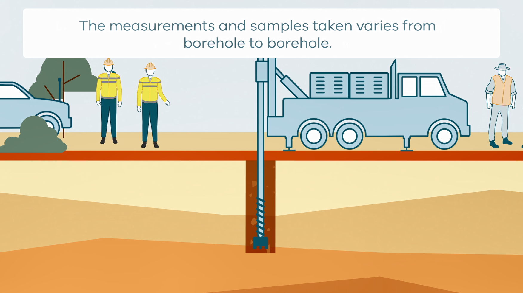
This animation shows how stratigraphic drilling is conducted. It is part of a series of Field Activity Technique Engagement Animations. The target audience are the communities that are impacted by GA's data acquisition activities. There is no sound or voice over. The 2D animation includes a simplified view of what stratigraphic drilling looks like, what measurements and samples are taken, and how scientists use the data.
-
This Record documents the efforts of the Geological Survey of Victoria (GSV) and Geoscience Australia (GA) in compiling a geochronology (age) compilation for Victoria, describing both the dataset itself and the process by which it is incorporated into the continental-scale Isotopic Atlas of Australia. The Isotopic Atlas draws together age and isotopic data from across the country and provides visualisations and tools to enable non-experts to extract maximum value from these datasets. Data is added to the Isotopic Atlas in a staged approach with priorities determined by GA- and partner-driven focus regions and research questions. This dataset, which was primarily compiled by GSV and has been supplemented with data compiled by GA during the 2013–2017 Stavely Project, is a foundation for the second phase of the Exploring for the Future initiative over 2020–2024, particularly the Darling-Curnamona-Delamerian Project.
-
Crustal architecture places first-order controls on the distribution of mineral and energy resources. However, despite its importance, it is poorly constrained over much of northern Australia. Here, we present a full crustal interpretation of deep seismic reflection profile 18GA-KB1 that extends over 872 km from the Eo- to Mesoarchean Pilbara Craton to the Paleoproterozoic Aileron Province, transecting a range of stratigraphic and tectonic basement units, some of which are completely concealed by younger rocks. The seismic profile provides the first coherent image through this relatively poorly understood part of Australian geology and yields major new insights about the crustal architecture, geometry and definition of the different geological and seismic provinces and their boundaries. Key findings include the following: (1) The Pilbara Craton shows a three-component horizontal crustal layering, where the granite– greenstone East Pilbara Terrane is largely confined to the upper crust. (2) The Pilbara Craton has an extensive reworked margin, the Warrawagine Seismic Province, that thins towards the east, and underlies the western and central Rudall Province. (3) At the largest scale, the Rudall Province shows an approximately funnel-shaped geometry, with limited differences in seismic character between the various terranes. (4) The western Kidson Sub-basin is underlain by rocks of the Neoproterozoic Yeneena Basin and Rudall Province. (5) The central and eastern part of the Kidson Sub-basin rests on the coherent, relatively poorly structured Punmu Seismic Province, which is truncated by the steep, crustal-scale Lasseter Shear Zone, that marks the boundary to the Aileron Province to the east. <b>Citation:</b> Doublier, M.P., Johnson, S.P., Gessner, K., Howard, H., Chopping, R., Smithies, R.H., Martin, D.McB.,Kelsey, D.E., Haines, P.w., Hickman, A., Czarnota, K., Southby, C., Champion, D.C., Huston, D.L., Calvert, A.J., Kohanpour, F., Moro, P., Costelloe, R., Fomin, T. and Kennett, B.L.N., 2020. Basement architecture from the Pilbara Craton to the Aileron Province: new insights from deep seismic reflection line 18GA-KB1. In: Czarnota, K., Roach, I., Abbott, S., Haynes, M., Kositcin, N., Ray, A. and Slatter, E. (eds.) Exploring for the Future: Extended Abstracts, Geoscience Australia, Canberra, 1–4.
-
The Exploring for the Future program is an initiative by the Australian Government dedicated to boosting investment in resource exploration in Australia. As part of the Exploring for the Future program, this study aims to improve our understanding of the petroleum resource potential of northern Australia. This data release presents new field emission scanning electron microscopy (FE-SEM) of broad ion beam- polished samples (BIB-SEM) to visualise mineral and organic matter (OM) porosity on 15 Proterozoic aged shales. Samples were selected from the Velkerri and Barney Creek formations in the McArthur Basin and the Mullera Formation, Riversleigh Siltstone, Lawn Hill and Termite Range formations in the South Nicholson region. Qualitative maceral analysis of the 15 samples are described in addition to bitumen reflectance measurements. These samples were analysed at the Montanuniversität Leoben, Austria in June 2020. The results of this study can be used to improve our understanding of porosity, microstructures, seal capacity and hydrocarbon prospectivity of Proterozoic aged sedimentary basins in northern Australia.
-
The Ordovician to Cretaceous Canning Basin of Western Australia is an underexplored prospective onshore petroleum basin with proven petroleum systems currently producing on a small-scale. The Canning Basin has recently become a site of interest for unconventional hydrocarbon exploration, with several formations within deeper basin depocentres being investigated for resources and estimates that suggest it may have the largest shale gas potential in Australia. Modern petroleum resource evaluation generally depends on an understanding of both local and regional stresses, which are a primary control over the formation and propagation of induced fractures. Presently, there are significant gaps in our understanding of these factors within the Canning Basin. This study characterises the regional stress regime of the onshore Canning Basin and presents detailed models of present-day stress within the subsurface. These allow for the identification of significant stress heterogeneities and natural barriers to fracture propagation. Wireline data interpretation reveals a variable present-day state of stress in the Canning Basin. An approximately NE-SW regional present-day maximum horizontal stress orientation is interpreted from observed wellbore failure in image logs, in broad agreement with both the Australian Stress Map and previously published earthquake focal mechanism data. One-dimensional mechanical earth models constructed for intervals from 15 Canning Basin petroleum wells highlight the relationship between lithology and stress. This study describes significant changes in stress within and between lithological units due to the existence of discrete mechanical units, forming numerous inter- and intra- formational stress boundaries likely to act as natural barriers to fracture propagation, particularly within units currently targeted for their unconventional resource potential. Broadly, a strike-slip faulting stress regime is interpreted through the basin, however, when analysed in detail there are three distinct stress zones identified.: 1) a transitional reverse- to strike-slip faulting stress regime in the top ~1 km of the basin, 2) a strike-slip faulting stress regime from ~1 km to ~3.0 km depth, and 3) a transitional strike-slip to normal faulting regime at depths greater than ~3.0 km. This study is a component of the Australian Government’s Exploring for the Future (EFTF) initiative, which is focused on gathering new data and information about the resource potential concealed beneath the surface across northern Australia. Appeared online in the Australian Journal of Earth Sciences 17 Feb 2021
-
The Exploring for the Future (EFTF) program is an initiative by the Australian Government dedicated to boosting investment in resource exploration in Australia. Geoscience Australia’s EFTF Energy program is aimed at improving the understanding of the petroleum resource potential of Australia. A key to understanding resource potential and basin evolution is a reliable time frame to correlate rock units. This palynological reconnaissance study focusses on the acid-resistant organic-walled microfossils (or palynomorphs) recovered from 42 samples taken within the fully cored Lower Ordovician Nambeet Formation (1354.80–2435.04 mRT) in the Barnicarndy 1 stratigraphic well, located in the Barnicarndy Graben, Canning Basin. The lack of palynomorph recovery from the Barnicarndy Formation, Yapukarninjarra Formation, and Neoproterozoic Yeneena Basin, also intersected in this well, means that the age of those units remain undated using micropalaeontological methods. The purpose of this study is to assess the yield and preservation of recovered palynomorphs, and determine their utility for regional, and international, correlation of the Lower Ordovician sedimentary section. Although the total organic matter content of the sampled Lower Ordovician core is typically low (average ≤0.2 wt%), reflecting sediment deposition in an oxidising, open marine environment, a diverse suite of palynomorphs has been identified and includes: acritarchs (of probable algal origin); other algal microfossils (including green algae, or prasinophytes); probable cyanobacteria; cryptospores (derived from the earliest land plants); graptolites and chitinozoans (both from extinct marine groups); scolecodonts (detached elements of worm jaws); and organic-walled tubes, some of which are of either probable fungal or cyanobacterial origin. Digital images accompany this record and include examples of all of these aforementioned microfossils. Microfossil yield per sample is, mostly, low; and preservation ranges from poor, where specimens are either fragmentary and/or distorted by pyrite crystal growth, to good; and commonly both preservation states occur together within the same sample. As with the admixture of preservation states per sample, palynomorph colour, typically used as an indicator of thermal maturity of organic matter, commonly ranges from thermally mature (brown) to over mature (black), often within the same Lower Ordovician core sample. This is tempered by the fact that these observations are based, mostly, on oxidised kerogen preparations, but, the relative maturity indicators remain valid. The occurrence of acritarchs assigned to the Rhopaliophora pilata–R. palmata complex, together with Athabascaella playfordii, and Aryballomorpha grootaertii, allows correlation with assemblages previously recovered from the Nambeet Formation intersected in two petroleum exploration wells in the Canning Basin (Samphire Marsh 1, type section; and Acacia 2). These species also occur globally, with A. grootaertii recovered from sedimentary rocks in southern China and Canada that have been independently dated as Early Ordovician, late Tremadocian–early Floian (about 475–482 Ma). Conodont faunas from cores in Barnicarndy 1 record the same (late Tremadocian–early Floian) age, which enhances the utility of A. grootaertii for age dating. The dates also demonstrate that the Barnicarndy 1 well intersects some of the oldest Paleozoic sedimentary rocks in the Canning Basin. There are compositional differences between the palynological assemblages from the younger Samphire Marsh Member and underlying Fly Flat Member of the Nambeet Formation which, despite difficulties in sample processing, are genuine and reflect changes in the depositional environment. Most obvious is the record of Gloeocapsomorpha prisca and ?Eomerismopedia maureeniae, both of probable cyanobacterial affinity, with in situ occurrences in the Lower Ordovician Samphire Marsh Member. Earlier studies suggested that G. prisca was confined to younger (Middle) Ordovician palynological assemblages in the Canning Basin, and its common abundance was used as a biozone marker, but the occurrences reported here and in unpublished studies, have shown that this is no longer applicable. In younger Ordovician formations in the Canning Basin (notably the upper Goldwyer Formation), and globally, G. prisca is an important organism contributing to the hydrocarbon potential of Paleozoic marine source rocks. If present in greater abundance elsewhere in the basin, it could increase the petroleum prospectivity of the Nambeet Formation. A distinctively shaped acritarch, of probable algal origin, assigned to the genus Dactylofusa is restricted to an assemblage from the Fly Flat Member, and may be useful for future basinal biozone correlation. Most samples from the Samphire Marsh Member contain early land-plant spores, of probable bryophyte affinity, that sometimes occur together with irregularly-shaped spore clusters, likely derived from aeroterrestrial charophyte algae; both of which are collectively known as cryptospores. In addition, Grododowon orthagonalis, superficially similar to E. maureeniae and recorded in some samples from the Samphire Marsh Member, is also considered to be of charophyte algal origin. The cryptospores include the species Dyadospora murusattenuata, Tetraplanarisporites sp., and Laevolancis divellomedium. Collectively, these cryptospores are important as they herald the first emergence of plants onto wetlands during the Early Ordovician; and being of late Tremadocian–early Floian age, they are amongst the oldest land-plant spores known in Australia and globally. The record of cryptospores from Barnicarndy 1 enhances those recently reported from the Nambeet Formation in Samphire Marsh 1, and from the lower Goldwyer Formation in Theia 1. Locally, the cryptospore record demonstrates a supply of terrestrial material into the marine environment during deposition of the Samphire Marsh Member. Globally, records of these cryptospores contribute to the understanding of the evolution and geographic distribution of the earliest land flora. Inevitably, there are microfossils found in this study that could be described as new species, and a detailed systematic study of all fossil groups is recommended to realise their utility for zonal correlation and age dating. The palynological data presented here provide complementary information to the conodont age dating, organic petrological, and organic geochemical studies conducted on the Barnicarndy 1 core. Collectively, these studies contribute to a better understanding of the depositional history and hydrocarbon prospectivity of the Canning Basin.
-
To test existing geological interpretations and the regional stratigraphic relationships of the Carrara Sub-basin with adjacent resource-rich provinces, the deep stratigraphic drill hole NDI Carrara 1 was located on the western flanks of the Carrara Sub-basin, on the seismic line 17GA-SN1. The recovery of high quality near-continuous core from the Carrara Sub-basin, in concert with the spectrum of baseline analytical work being conducted by Geoscience Australia through the EFTF program, as well as other work by government and university researchers is greatly improving our understanding of this new basin. While recently published geochemistry baseline datasets have provided valuable insight into the Carrara Sub-basin, the age of the sedimentary rocks intersected by NDI Carrara 1 and their chronostratigraphic relationships with adjacent resource rich regions has remained an outstanding question. In this contribution, we present new sensitive high-resolution ion microprobe (SHRIMP) geochronology results from NDI Carrara 1 and establish regional stratigraphic correlations to better understand the energy and base-metal resource potential of this exciting frontier basin in northern Australia.
-
Geoscience Australia has compiled U-Pb datasets from disparate sources into a single, standardised and publicly-available U–Pb geochronology compilation for all Australia. The national maps presented in this poster expand upon the data coverage previously compiled by Anderson et al. (2017) and Jones et al. (2018), which covered northern and western Australia only. This extension of a national coverage has been achieved through the development of Geoscience Australia’s Interpreted Ages database. In this database, there are now >4000 U–Pb sample points compiled from across Australia, with significant datasets to come from the southern Australia regions. These will be available to the public in the coming months through the Exploring for the Future Data Discovery Portal (eftf.ga.gov.au).
-
Borehole induction conductivity (IC) and gamma logging are geophysical techniques that provide bulk electrical conductivity and natural gamma trends of geological formations. The measured unit of IC is millisiemens per metre, whereas natural gamma is either counts per second or American Petroleum Index (API). The data were acquired as part of the Exploring for the Future program at field sites within the East Kimberley area in Western Australia, and the northern and southern Stuart Corridor projects in the Northern Territory. Data may be downloaded as Log ASCII Standard (LAS) format files or viewed through the Geoscience Australia Portal, or accessed via Geoscience Australia’s WMS and WFS web services.