Earthquakes
Type of resources
Keywords
Publication year
Service types
Topics
-
Seismic Station ADE Teleseismic times charts. 2002-2008
-
This catalogue details earthquakes located by South Australian State Government Seismic Monitoring. Earthquake information extends from 1840 to 2017
-
Scanned enquires and insurance claims requesting information about South Australian Earthquake or Seismic data for teleseismic events. 1959-1987
-
This short video by the Geoscience Australia Education Team is targeted at primary students but is suitable for a wider audience. This video introduces the concepts of earthquake monitoring using seismometers and seismographs. It also features the National Earthquake Alert Centre. Viewers are asked to try making earthquakes at home using the accelerometers in their smartphones. For more education resources visit ga.gov.au/education.
-
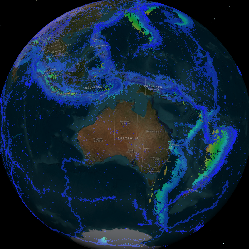
Geoscience Australia provides rapid, event-specific, earthquake information from its 24x7 earthquake information centre. Information in this service includes basic earthquake parameters (time, location and magnitude) and information about local effects including ground shaking (modelled). This includes all historic data.
-
<div>These videos are part of a series to provide tutorials in how to use the Earthquakes@GA portal in the classroom. They include guides for basic navigation, how to access summary data for recent earthquake events and how to make a felt report. They also demonstrate how to use the Search function to collect historic earthquake data across a range of criteria including location (both within Australia and across the world), date and time, and magnitude.</div><div>Videos included:</div><div>- Introduction to using the Earthquakes@GA data portal</div><div>- How to use the Search function in the Earthquakes@GA data portal</div><div><br></div><div>They are suitable for a secondary to senior secondary student and teacher audience.</div>
-
Geoscience Australia provides rapid, event-specific, earthquake information from its 24x7 earthquake information centre. Information in this service includes basic earthquake parameters (time, location and magnitude) and information about local effects including ground shaking (modelled).
-
<div>Students can access and analyse real world earthquake data using online portals created by Geoscience Australia (GA) (Geoscience Australia data portal and Earthquakes@GA). The document provides background information for teachers about earthquakes and the online portals, as well as two student inquiry activities. Each activity includes instructions on how to access and use the relevant portal as well as questions that prompt students to find, record, and interpret the data. An Excel table is provided to accompany one of the activities.</div><div><br></div><div>The activities are suitable for use with secondary to senior secondary science and geography students. The topics covered in these activities include: earthquakes, plate tectonics and natural hazards.</div><div><br></div><div>The print version has lines provided for written answers, the accessible version is intended for digital responses. </div>
-
Segmented time series data for earthquake events. Data are in raw digital counts and have associated instrument metadata for calibration to physical ground-motion measures. These data are used to inform a range of applications in seismic hazard assessment and for assessing the utility of current observatory practice for magnitude assessment. <b>Value: </b>Used in the selection and development of ground-motion models used for seismic hazard purposes. These data also enable the assessment and development of new earthquake magnitude formulae. <b>Scope: </b>Data has been collected on an ad hoc basis, some early digital data dates back to 1989 (i.e. Newcastle earthquake), and the dataset continues to grow as earthquakes of interest occur, or various temporary deployments are rolled out. Instrument metadata is not always known.
-
Scanned phase data for station ADE, Mt Bonython, 1958-1983