Mapping
Type of resources
Keywords
Publication year
Service types
Topics
-
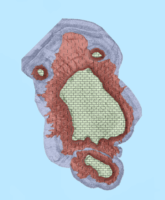
This ESRI map (web) service contains geospatial seabed morphology and geomorphology information for Flinders Reefs within the Coral Sea Marine Park and are intended for use by marine park managers, regulators, the general public and other stakeholders. This web service uses the data product published in McNeil et al. (2023); eCat Record 147998.
-
This OGC Web Map Service (WMS) contains geospatial seabed morphology and geomorphology information for Flinders Reefs within the Coral Sea Marine Park and are intended for use by marine park managers, regulators, the general public and other stakeholders. This web service uses the data product published in McNeil et al. (2023); eCat Record 147998.
-
<div>Alkaline and related rocks are a relatively rare class of igneous rocks worldwide. Alkaline rocks encompass a wide range of rock types and are mineralogically and geochemically diverse. They are typically though to have been derived by generally small to very small degrees of partial melting of a wide range of mantle compositions. As such these rocks have the potential to convey considerable information on the evolution of the Earth’s mantle (asthenosphere and lithosphere), particularly the role of metasomatism which may have been important in their generation or to which such rocks may themselves have contributed. Such rocks, by their unique compositions and or enriched source protoliths, also have considerable metallogenic potential, e.g., diamonds, Th, U, Zr, Hf, Nb, Ta, REEs. It is evident that the geographic occurrences of many of these rock types are also important, and may relate to presence of old cratons, craton margins or major lithospheric breaks. Finally, many alkaline rocks also carry with them mantle xenoliths providing a snapshot of the lithospheric mantle composition at the time of their emplacement.</div><div><br></div><div>Accordingly, although alkaline and related rocks comprise only a volumetrically minor component of the geology of Australia, they are of considerable importance to studies of lithospheric composition, evolution and architecture and to helping constrain the temporal evolution of the lithosphere, as well as more directly to metallogenesis and mineralisation.</div><div><br></div><div>This contribution presents data on the distribution and geology of Australian alkaline and related rocks of Proterozoic age. Proterozoic alkaline and related rocks are primarily restricted to the western two-thirds of the Australia continent, congruent with the distribution of Proterozoic rocks more generally. Proterozoic alkaline rock units are most abundant in Western Australia and the Northern Territory, with minor occurrences in South Australia, and the western regions of Queensland, New South Wales and Tasmania.</div><div><br></div><div>The report and accompanying GIS document the distribution, age, lithology, mineralogy and other characteristics of these rocks (e.g., extrusive/intrusive, presence of mantle xenoliths, presence of diamonds), as well as references for data sources and descriptions. The report also reviews the nomenclature of alkaline rocks and classification procedures. GIS metadata are documented in the appendices. </div>
-
This OGC Web Feature Service (WFS) contains geospatial seabed morphology and geomorphology information for the Beagle Marine Park (South-east Marine Parks Network) and is intended for use by marine park managers, regulators and other stakeholders. This web service uses the data product published in Nanson et al. (2023); eCat Record 147976.
-
This OGC Web Feature Service (WFS) contains seabed morphology and geomorphology information for a subset area of Zeehan Marine Park (South-east Marine Parks Network) and is intended for use by marine park managers, regulators and other stakeholders. This web service uses the data product published in McNeil et al. (2023); eCat Record 148620.
-
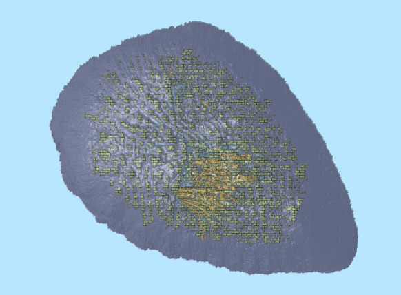
This ESRI map (web) service contains geospatial seabed morphology and geomorphology information for Cairns Seamount within the Coral Sea Marine Park and are intended for use by marine park managers, regulators, the general public and other stakeholders. This web service uses the data product published in McNeil et al. (2023); eCat Record 147998.
-
Delineation of Australia's domestic and international maritime limits and boundaries. These boundaries include a variety of jurisdictional, economic, regulatory and legal boundaries. <b>Value:</b> Used by national governments, businesses, organisations in determining boundaries for zones governed/managed by different regulatory structures/requirements. <b>Scope:</b> A national dataset at resolution relevant for presentation of regional spatial data such as digital maps or regional decision making.
-
<div>The Proterozoic alkaline and related igneous rocks of Australia is a surface geology compilation of alkaline and related igneous rocks of Proterozoic age in Australia. This dataset is one of five datasets, with compilations for Archean, Paleozoic, Mesozoic and Cenozoic alkaline and related igneous rocks already released.</div><div><br></div><div>Geological units are represented as polygon and point geometries and, are attributed with information that includes, but is not limited to, stratigraphic nomenclature and hierarchy, age, lithology, composition, proportion of alkaline rocks, body morphology, unit expression, emplacement type, presence of mantle xenoliths and diamonds, and primary data source. Source data for the geological unit polygons provided in Data Quality LINEAGE. Geological units are grouped into informal geographic “alkaline provinces”, which are represented as polygon geometries, and attributed with information similar to that provided for the geological units.</div>
-
Mapped and projected extents of geology and geologic features in Australia, including: surface geology, regolith geology, solid geology, chronostratigraphic surfaces, and province boundaries. The database includes igneous, sedimentary and structural characteristics, age limits, parent and constituent units, relations to surrounding provinces, and mineral and petroleum resources. based on field observations interpretations of geophysics and borehole data. <b>Value:</b> Data used for understanding surface and near surface geology. The data can be used for a variety of purposes, including resource exploration, land use management, and environmental assessment. <b>Scope:</b> Australia and Australian Antarctic Territory
-
This OGC Web Map Service (WMS) contains geospatial seabed morphology and geomorphology information for the Beagle Marine Park (South-east Marine Parks Network) and is intended for use by marine park managers, regulators and other stakeholders. This web service uses the data product published in Nanson et al. (2023); eCat Record 147976.