Magnetic
Type of resources
Keywords
Publication year
Service types
Topics
-
<div>Geoscience Australia’s Exploring for the Future program provides precompetitive information to inform decision-making by government, community and industry on the sustainable development of Australia's mineral, energy and groundwater resources. By gathering, analysing and interpreting new and existing precompetitive geoscience data and knowledge, we are building a national picture of Australia’s geology and resource potential. This leads to a strong economy, resilient society and sustainable environment for the benefit of all Australians. This includes supporting Australia’s transition to net zero emissions, strong, sustainable resources and agriculture sectors, and economic opportunities and social benefits for Australia’s regional and remote communities. The Exploring for the Future program, which commenced in 2016, is an eight year, $225m investment by the Australian Government. This work contributes to building a better understanding of the Australian continent, whilst giving the Australian public the tools they need to help them make informed decisions in their areas of interest.</div><div><br></div><div>As part of the Australia's Resources Framework Project, in the Exploring for the Future Program, Geoscience Australia and CSIRO undertook a magnetic source depth study across four areas, with the objectives of generating cover model constraints from magnetic modelling to expand national coverage, and to improve our subsurface understanding of these areas. During this study, 2005 magnetic estimates of depth to the top of magnetization were generated, with solutions derived using a consistent methodology (targeted magnetic inversion modelling, or TMIM; also known as ‘sweet-spot’ modelling). The methodology for these estimates are detailed in a summary report by Foss et al (2024), and is available for download through Geoscience Australia’s enterprise catalogue (https://pid.geoscience.gov.au/dataset/ga/149239). </div><div><br></div><div>The new points were generated over four areas: 1) the western part of Tasmania that is the southernmost extension of the Darling-Curnamona-Delamerian (DCD) project area; 2) northeastern Queensland; 3) the Officer Basin area of western South Australia and southeastern West Australia; and 4) the Eastern Resources Corridor (ERC), covering eastern South Australia, southwest Queensland, western New South Wales and western Victoria. These depth estimates have been released, together with a summary report detailing the data and methodology used to generate the results, through Geoscience Australia's product catalogue (ecat) at https://pid.geoscience.gov.au/dataset/ga/149239.</div><div><br></div><div>This supplementary data release contains the chronostratigraphic attribution of the new TMIM magnetic depth estimates, which range in depth from at surface to 13,294 m below ground. To ensure that the interpretations took into account the local geological features, the magnetic depth estimates were integrated and interpreted with other geological and geophysical datasets, including borehole stratigraphic logs, potential fields images, surface and solid geology maps, and airborne electromagnetic interpretations (where available). </div><div><br></div><div>Each depth-solution is interpretively ascribed to either a chronostratigraphic boundary with the stratigraphic units above and below the depth estimate, or the stratigraphic unit that the depth estimate occurs within, populated from the Australian Stratigraphic Units Database (ASUD). Stratigraphic attribution adds value and informs users of the depth to certain stratigraphic units in their areas of interest. Each solution is accompanied by confidence estimates. The depth estimate points are formatted for compliance with Geoscience Australia’s (GA) Estimates of Geological and Geophysical Surfaces (EGGS) database, the national repository for standardised depth estimate points. </div><div><br></div><div>Results from these interpretations provided some support to stratigraphic drillhole targeting, as part of the Delamerian Margins NSW National Drilling Initiative campaign, a collaboration between GA’s EFTF program, the MinEx CRC National Drilling Initiative and the Geological Survey of New South Wales. The magnetic depth-estimate solutions produced within this study provide important depth constraints in data-poor areas. These data help to construct a better understanding of the 3D geometry of the Australian continent and aid in cover thickness modelling activities. The availability of the depth-estimate solutions via the EGGS database through Geoscience Australia’s Portal creates enduring value to the public.</div>
-
Geoscience Australia is the custodian of the most comprehensive publicly available Australian airborne magnetic, gamma-ray, seismic, electromagnetic and gravity data sets. The airborne geophysics data set contains approximately 34 million line kilometres of data, which, at current prices, would cost approximately $197 million to acquire. The gravity data set contains more than 1.57 million reliable onshore stations gathered during more than 1800 surveys. The collection also includes a large number of seismic surveys from Australia's offshore basins. The onshore component of this data set was previously approved for RDSI for 8 TB. This proposal extends the collection to 150TB. The data types and access methods for the Offshore and Onshore data are identical Certain holdings are additionally hosted at the NCI (see downloads)
-
<p>The Geological Survey of South Australia commissioned the Gawler Craton Airborne Survey (GCAS) as part of the PACE Copper initiative. The airborne geophysical survey was flown over parts of the Gawler Craton in South Australia. The program was designed to capture new baseline geoscientific data to provide further information on the geological context and setting of the area for mineral systems (http://energymining.sa.gov.au/minerals/geoscience/pace_copper/gawler_craton_airborne_survey). <p>The survey design of 200 m spaced lines at a ground clearance of 60 m can be compared with the design of previous regional surveys which generally employed 400 m line spacing and a ground clearance of 80 m. The new survey design results in ~2 x the data coverage and ~25% closer to the ground when compared to previous standards for regional surveys in South Australia. <p>Survey blocks available for download include: <p>Streaky Bay, block 5 <p>Gairdner, block 6A <p>Spencer, block 7 <p>Kingoonya, block 9B <p>The following grids are available in this download: <p>• Laser-derived digital elevation model grids (m). Height relative to the Australian Height Datum. <p>• Radar-derived digital elevation model grids (m). Height relative to the Australian Height Datum. <p>• Total magnetic intensity grid (nT). <p>• Total magnetic intensity grid with variable reduction to the pole applied (nT). <p>• Total magnetic intensity grid with variable reduction to the pole and first vertical derivative applied (nT/m). <p>• Dose rate concentration grid (nGy/hr). <p>• Potassium concentration grid (%). <p>• Thorium concentration grid (ppm). <p>• Uranium concentration grid (ppm). <p>• NASVD processed dose rate concentration grid (nGy/hr). <p>• NASVD processed potassium concentration grid (%). <p>• NASVD processed thorium concentration grid (ppm). <p>• NASVD processed uranium concentration grid (ppm). <p>The following point located data are available in this download: <p>• Elevation. Height relative to the Australian Height Datum. Datum: GDA94 <p>• Total Magnetic Intensity. Datum: GDA94 <p>• Radiometrics. Datum: GDA94
-
Data accompanying the GA Record Regional geology and mineral systems of the Stavely region, western Victoria. Data release 6 - Pre-drilling geophysics. Prior to stratigraphic drilling, existing airborne magnetic data were analysed and new refraction seismic, reflection seismic and gravity data were acquired as part of a pre-drilling geophysical acquisition program. The aim of this geophysical program was to provide cover thickness estimates at the drill site locations prior to the drilling program commencing, in order to reduce the geological and financial risk. Passive seismic data were acquired post-drilling for benchmarking with the other methods against the completed drilling in order to assess a potential tool kit of geophysical methods for the explorer to predict reliably the cover thickness at the tenement scale. This is the first study where multiple geophysical methods are applied to the same site and where full drill core, downhole wireline logging and hyperspectral (HyLogger) data are freely available.
-
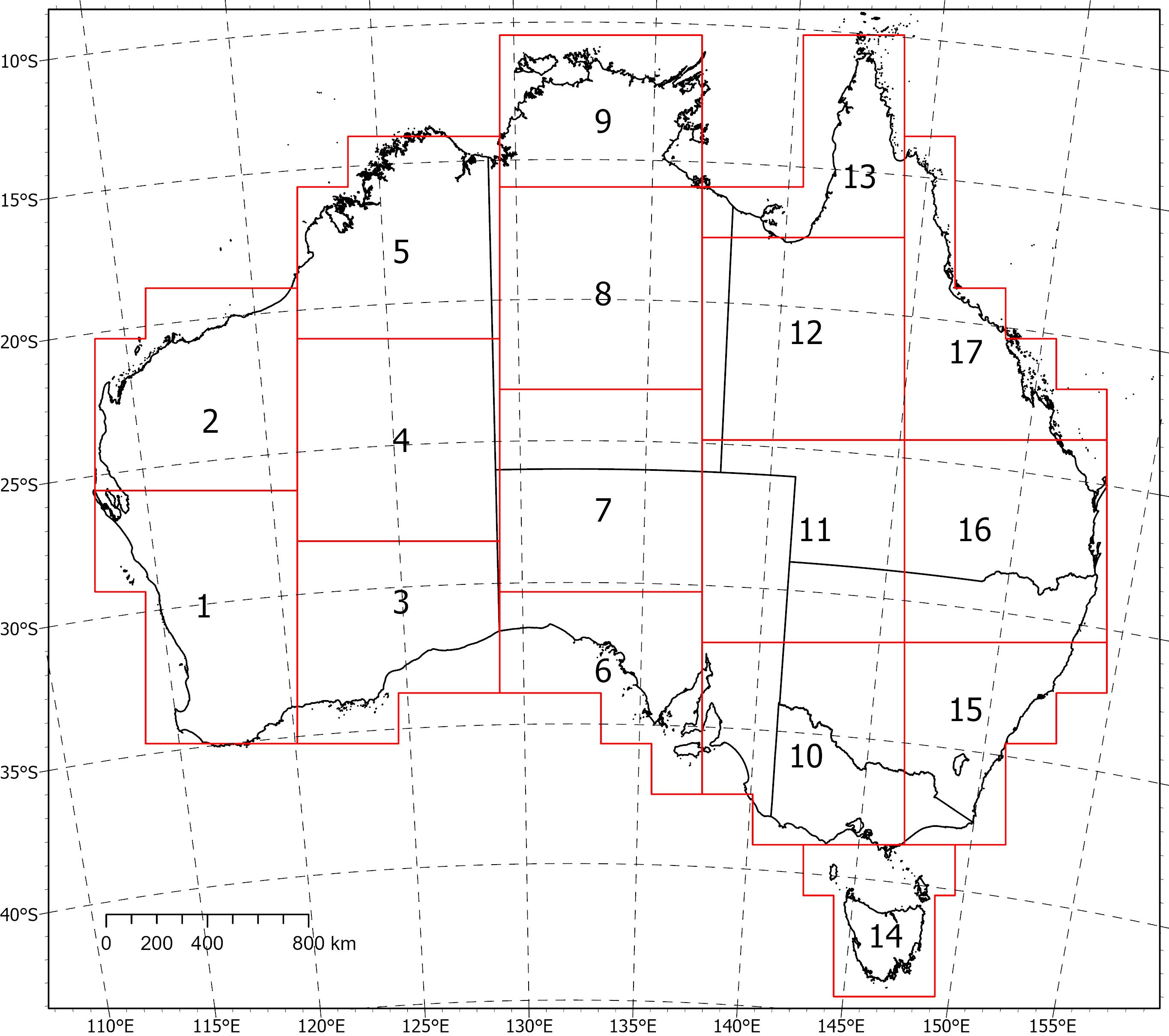
<div>Two coincident, crustal-scale models, one of magnetic susceptibility and one of density, have been produced for a volume covering the Australian continent and extending down to 55.5 km depth. These models were produced using the UBC‑GIF MAG3D and GRAV3D inversion programs, respectively.</div><div><br></div><div>The inversions were constrained with geological reference models with layers for sediments, undifferentiated crust and the mantle. The reference model for the magnetic inversion incorporated a Curie depth surface below which magnetic susceptibility was set to zero.</div><div><br></div><div>Due to the size of the inversion problem to be solved, the volume was divided into 235 overlapping inversions, which were inverted separately and then recombined. The method of recombining the inversions relies on a cosine function to determine the weight of each property and then takes a weighted average. This method successfully attenuated the edge effects that would otherwise occur between models and allows them to be viewed as one seamless model that covers the whole of Australia.</div><div><br></div><div>Regions of coincident high-density (>2.83 g/cm<sup>3</sup>) and high-magnetic susceptibility (>0.0125 SI) within the top 8‑9 km of the undifferentiated crust are suggested to be related to ultramafic rocks and the magnetite-forming hydrothermal alteration stages of potentially fertile IOCG systems. Currently the models are available in UBCGIF format (.den/.sus) only. Other formats and all supporting input data will be added in the near future. Due to their size, the models have been divided into subsets (labelled 1-17) for download. Please refer to the image below for the extent of the subsets.
-
This service provides Estimates of Geological and Geophysical Surfaces (EGGS). The data comes from cover thickness models based on magnetic, airborne electromagnetic and borehole measurements of the depth of stratigraphic and chronostratigraphic surfaces and boundaries.
-
Survey Name: East Tasmania Datasets Acquired: Magnetics, Radiometrics and Elevation Geoscience Australia Project Number: P5020 Acquisition Start Date: 20/03/2022 Acquisition End Date: 23/06/2022 Flight line spacing: 200 m Flight line direction: East-West (090-270) Total distance flown: 57,709 line-km's Nominal terrain clearance: 80 m Data Acquisition: Magspec Airborne Surveys Pty Ltd Project Management: Geoscience Australia Quality Control: Geoscience Australia Dataset Ownership: Geoscience Australia and Mineral Resources Tasmania Datum: Geocentric Datum of Australia 2020 (GDA2020) Projection: Map Grid of Australia 55 (MGA55) Included in this release: 1. Point-located Data - ASCII-column (.dat) or NetCDF (.nc) format. • Magnetic diurnal; • Magnetics raw-edited; • Magnetics reduced; • Radiometrics raw-edited; • Radiometrics reduced. 2. Gridded data - ERMapper (.ers) format. • Total magnetic intensity (TMI); • TMI reduced to pole (RTP); • TMI RTP with first vertical derivative (1VD) applied; • Dose rate (with NASVD and standard processing); • Potassium concentration (with NASVD, standard processing); • Thorium concentration (with NASVD, standard processing); • Uranium concentration (with NASVD, standard processing); • Radar-derived digital elevation model (geoidal). 3. Reports. • Calibration report; • Operations and processing summary report. © Commonwealth of Australia (Geoscience Australia) and Mineral Resources Tasmania, Government of Tasmania 2022. With the exception of the Commonwealth Coat of Arms and where otherwise noted, this product is provided under a Creative Commons Attribution 4.0 International Licence (http://creativecommons.org/licenses/by/4.0/legalcode).
-
NDI Carrara 1 is a deep stratigraphic drill hole completed in 2020 as part of the MinEx CRC National Drilling Initiative (NDI) in collaboration with Geoscience Australia and the Northern Territory Geological Survey. It is the first test of the Carrara Sub-Basin, a depocentre newly discovered in the South Nicholson region based on interpretation from seismic surveys (L210 in 2017 and L212 in 2019) recently acquired as part of the Exploring for the Future program. The drill hole intersected approximately 1100 m of Proterozoic sedimentary rocks uncomformably overlain by 630 m of Cambrian Georgina Basin carbonates. A comprehensive geochemical program designed to provide information about the region’s resource potential was carried out on samples collected at up to 4 meter intervals. This report presents data from magnetic susceptibility analyses undertaken by Geoscience Australia on selected rock samples to establish their ability to be magnetised in an applied external magnetic field.
-
<div>In July 2022 an airborne electromagnetic (AEM) survey was flown over and around the proposed site of the National Radioactive Waste Management Facility near the township of Kimba in South Australia. The survey was commissioned by the Australian Radioactive Waste Agency, and was project managed by Geoscience Australia. The survey has Geoscience Australia airborne survey project number P5008.</div><div><br></div><div>The survey was flown by Skytem Australia Pty Ltd using its SkyTEM312Fast AEM system. The survey was conducted on east-west lines at 500 m spacing, with a smaller central focus area of 100 m spaced lines, acquiring a total of 2,545 line kilometres of data. Skytem Australia Pty Ltd also processed the data.</div><div><br></div><div>This data package includes the acquisition and processing report, the final processed AEM data and the results of the 1D laterally constrained inversion of the data to conductivity-depth estimates that was carried out by the contractor.</div>
-
<div>This document defines the technical standards set by Geoscience Australia for the acquisition, processing and supply of airborne magnetic, horizontal magnetic gradient and radiometric (gamma-ray spectrometric) data. The technical standards cover the requirements for equipment, calibrations, quality control checks, reporting and data formats for airborne surveys.</div><div><br></div><div><br></div><div><strong>Table of Contents</strong></div><div><br></div><div>Attachment 1A – Data Acquisition and Processing</div><div><br></div><div>1 Aircraft</div><div>2 Flight and Tie Lines</div><div>3 Global Navigation Satellite System (GNSS)</div><div>4 Parallax Correction</div><div>5 Altimeter</div><div>6 Barometer</div><div>7 Digital Elevation Model</div><div>8 Magnetic System Equipment</div><div>9 Magnetic Gradient System Equipment</div><div>10 Magnetic / Gradient Calibration and Quality Tolerances</div><div>11 Magnetic Base Station (Diurnal Monitoring)</div><div>12 Magnetic Data Reduction</div><div>13 Magnetic Gradient Data Reduction</div><div>14 Radiometric System Equipment</div><div>15 Radiometric Calibration and Quality Tolerances</div><div>16 Radiometric Data Reduction</div><div><br></div><div>Attachment 1B – Reporting and Data Supply</div><div><br></div><div>1 General</div><div>2 Calibration Report</div><div>3 Daily Acquisition Report</div><div>4 Weekly Acquisition Report</div><div>5 Operations and Processing Summary Report</div><div>6 Supply Schedule</div><div><br></div><div>Attachment 1C – Data Formats</div><div><br></div><div>1 General</div><div>2 Point-Located Data Files</div><div>3 Definition Files</div><div>4 Description Files</div><div>5 Raw-Edited Magnetic Data File</div><div>6 Reduced Magnetic Data File</div><div>7 Diurnal Magnetic Data File</div><div>8 Raw-Edited Magnetic Gradient Data File</div><div>9 Reduced Magnetic Gradiometry Data File</div><div>10 Raw-Edited Radiometric Data File</div><div>11 Reduced Radiometric Data File</div><div>12 Gridded Data Files</div><div>13 Image Enhanced GeoTIFF Files