Minerals
Type of resources
Keywords
Publication year
Service types
Topics
-
<div>A series of mineral identification charts, including streak and density.</div>
-
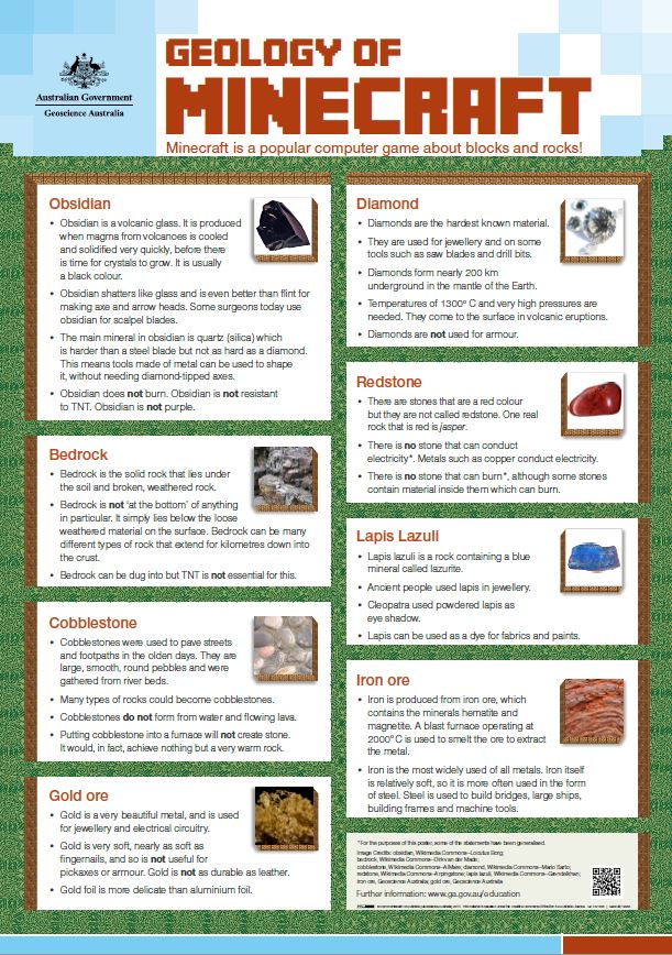
A colour poster comparing the concepts in the computer game Minecraft with the geology of particular minerals and rocks. Aimed at school children, for display in classrooms. Designed to be printed at A2, but can also be printed smaller.
-

A second colour poster comparing the concepts in the computer game Minecraft with particular minerals and rocks. Aimed at school children, for display in classrooms. Designed to be printed at A2, but can also be printed smaller.
-
Statements of existing knowledge are compiled for known mineral, coal, hydrocarbon and carbon capture and storage (CCS) resources and reserves in the Cooper Basin. This data guide illustrates the current understanding of the distribution of these key resource types within the Cooper Basin region based on trusted information sources. It provides important contextual information on the Cooper Basin and where additional details on discovered resources can be found. To date, mineral or coal deposits have not been found in the Cooper Basin, due to its depth. There are significant hydrocarbon resources found in the basin, including conventional and unconventional hydrocarbons. The Cooper Basin has been a major producer of oil and gas since the 1960s (Smith, Cassel and Evans, 2015). It is one of the largest sources of onshore hydrocarbon production in Australia. Some of the largest unconventional gas resources are contained in the basin. This is mostly basin-centred gas. The geology in the Cooper Basin is considered suitable for use in Carbon Capture and Storage (CCS) projects. The Cooper Basin and overlying Eromanga Basin contain 2 CCS projects that are currently being developed.
-
<div>This data accompanies the Australian Operating Mines Map 2021 (twenty-second edition) March 2022. The Australian Operating Mines Map 2021 may be downloaded from the Geoscience Australia website at: https://pid.geoscience.gov.au/dataset/ga/146335</div>
-
Australia's Identified Mineral Resources is an annual national assessment that takes a long-term view of Australian mineral resources likely to be available for mining. The assessment also includes evaluations of long-term trends in mineral resources, world rankings, summaries of significant exploration results and brief reviews of mining industry developments.
-
Publicly available geological data in the Adavale Basin region are compiled to produce statements of existing knowledge for natural hydrogen, hydrogen storage, coal and mineral occurrences. This data guide also contains an assessment of the potential for carbon dioxide (CO2) geological storage and minerals in the basin region. Geochemical analysis of gas samples from petroleum boreholes in the basin shows various concentrations of natural hydrogen. However, the generation mechanism of the observed natural hydrogen concentration is still unknown. The Adavale Basin also has the potential for underground hydrogen storage in the Boree Salt. Given the depth of the Boree Salt (wells have intersected the salt at depths below 1800 m) and the high fluid pressure gradient in the basin, the construction of underground salt caverns should include consideration of stability and volume shrinkage. Mineral occurrences are all found in the basins overlying the Adavale region. However, they are small (thousands of tonnes range) and not currently of economic interest. The Adavale Basin has potential for base and precious metal deposits due to suitable formation conditions, but the depth of the basin makes exploration and mining difficult and expensive. There are no identified occurrences or resources of coal in the Adavale Basin. Given the depth of the basin, extraction of any identified coal would probably be uneconomic, with the potential exception of coal seam gas extraction. An assessment of CO2 geological storage also shows prospective storage areas in the Eromanga Basin within the Adavale Basin region in the Namur-Murta and Adori-Westbourne play intervals.
-
<div>This look-book was developed to accompany the specimen display in the office of the Hon Madeleine King MP, Minister for Resources and Northern Australia. It contains information about each of the specimens including their name, link to resource commodities and where they were from. </div><div><br></div><div>The collection was carefully curated to highlight some of Australia’s well known resources commodities as well as the emerging commodities that will further the Australian economy and contribute to the low energy transition. The collection has been sourced from Geoscience Australia’s National Mineral and Fossil Collection. </div><div><br></div><div>The collection focuses on critical minerals, ore minerals as well as some fuel minerals. These specimens align with some of Geoscience Australia major projects including the Exploring For the Future (EFTF) program, the Trusted Environmental and Geological Information program (TEGI) as well as the Repository and the public education and outreach program. </div>
-
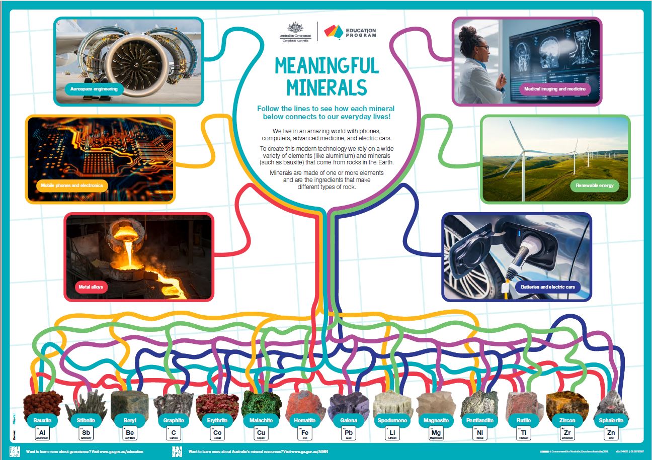
<div>This A1 poster aims to introduce Year 3/4 and older students to the many ways that minerals and elements are used in our everyday lives. </div><div> 6 key uses of 14 critical and strategic minerals are highlighted by colourful lines linking images. Students should take their time viewing the poster; they can follow the wiggly lines from minerals to product or vice versa and work out how many minerals link to each type of use.</div><div> The poster is also suitable for secondary students with the inclusion of a specific element name with each highlighted mineral plus the element symbol and atomic number.</div><div> The poster is intended to be a colourful rich stimulus to engage student interest in the resources from the ground used in our modern world.</div><div><br></div>
-
How do some of the rocks in Minecraft form and behave in real life? This short video discusses bedrock, obsidian and redstone using real rock samples and references to the game.