Houtman Sub-basin
Type of resources
Keywords
Publication year
Topics
-
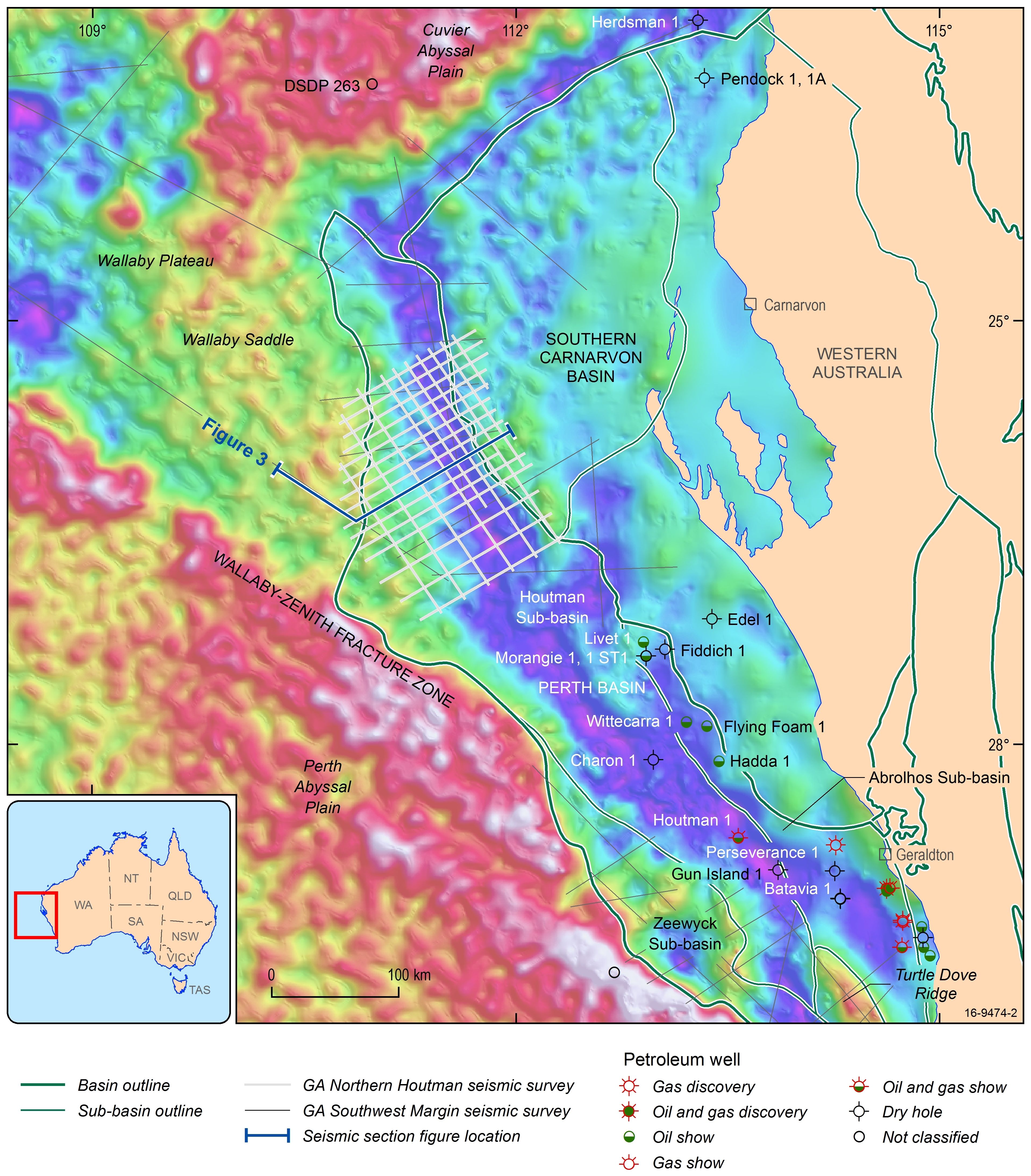
New 2D seismic data, acquired by Geoscience Australia in the northern Houtman Sub-basin of the Perth Basin, provides important information on the prospectivity of this frontier area. To date, lack of quality seismic data and limited geological understanding led to the perception that the hydrocarbon potential of the area is very low. However, interpretation of the newly collected data suggests that the northern Houtman depocentre contains up to 15 km of pre-breakup sediments composed of Permian, Triassic and Jurassic successions, which potentially contain multiple source rock, reservoir and seal intervals. The Permian synrift succession is confined to a series of large half-graben that are controlled by basement-involved faults separating the Houtman depocentre from the Bernier Platform. This succession is up to 10 km thick and is mapped throughout the inboard part of the new seismic grid. A prominent unconformity at the top of the Permian synrift sequence is overlain by a thick (up to 1800 m) and regionally extensive Kockatea Shale sequence, which has been tied to the regional interpretation of the basin. The thickness of the overlying Triassic succession ranges from about 1 km in the inboard part of the basin to up to 5 km further outboard. The Jurassic succession is thickest (up to 4 km) in the outboard part of the basin and is interpreted to contain sequences corresponding to the Cattamarra, Cadda and Yarragadee formations. Our study integrates new results from regional mapping, geophysical modelling and petroleum systems analysis, which enables a more accurate prospectivity assessment of this frontier basin.
-
The Houtman Sub basin is an under-explored region of the northern Perth Basin, offshore Western Australia. Only three wells have been drilled in the southern part of the sub-basin, while the northern part remains an exploration frontier. Adjacent areas of the Perth Basin are proven hydrocarbon provinces with a long and continuing history of exploration, discovery and production. New seismic reflection data, obtained by Geoscience Australia in 2014–15 (GA-349) under the Australian government's precompetitive data acquisition program, has been used to reassess the tectonic evolution, structural architecture, major depositional phases and petroleum prospectivity of this frontier basin. Interpretation of these data has enabled mapping of the Moho, basement, pre-rift sequences and major syn rift sequences, along with the creation of a 3D geological model covering the survey area. As a result, this study has significantly reduced the level of exploration risk in the northern Houtman Sub-basin. Seismic interpretation, integrated with potential field modelling, shows a large variation in crustal structure beneath the study area. Beneath the central part of the northern Houtman Sub-basin continental crust is highly extended to hyperextended (<5 km thick), while further east, beneath the Bernier Platform, continental crust remains greater than 25 km thick. This extreme change in crustal thickness occurred along a major fault zone, marking the eastern boundary of the northern Houtman Sub-basin. Located outboard, along the western margin of the northern Houtman Sub-basin, is a zone of volcanic seaward-dipping reflector sequences, defining the volcanic province of the Wallaby Saddle. Regional correlation of the seismic stratigraphy across the northern Perth Basin has enabled the development of a new tectonostratigraphic framework for the Houtman Sub basin. The depocentre includes up to 16 km of a Permian–Cretaceous succession underlain by a 2–3 km thick section of pre-rift (?Paleozoic) sediments. The Permian syn rift succession is confined to a series of large half graben that are controlled by basement-involved faults that separate the northern Houtman Sub-basin from the Bernier Platform. This succession is up to 10 km thick and was mapped throughout the inboard part of the new seismic grid. A prominent unconformity at the top of the Permian syn-rift sequence is overlain by a thick (up to 1800 m) and regionally extensive seismic sequence interpreted as the Lower Triassic Kockatea Shale. The thickness of the Triassic succession (i.e. Kockatea, Woodada and Lesueur formations) ranges from about 1 km in the inboard part of the basin to up to 5 km outboard. The Late Triassic to Jurassic succession is thickest (up to 4 km) in the outboard part of the basin and is interpreted to contain sequences corresponding to the Eneabba, Cattamarra, Cadda and Yarragadee formations. An Early Cretaceous depocentre was mapped in southwestern part of the study area, and is interpreted to be a Parmelia Group equivalent. Comparison with the adjacent hydrocarbon producing regions of the northern Perth Basin highlights the likely presence of multiple petroleum source, reservoir and seal units. Potential source rocks consist of Permian to Jurassic marine and non marine carbonaceous shale and coal, the most prospective of these is the marine Triassic Kockatea Shale, especially if the organic-rich Hovea Member is present. In addition, multiple reservoir and seal intervals are likely to be present throughout the thick Permian, Triassic, Jurassic and Lower Cretaceous successions.
-
In 2017, 21 new offshore petroleum exploration areas have been released. The majority of the areas are located along the North West Shelf spanning the Westralian Superbasin from the Bonaparte Basin in the north-east to the Northern Carnarvon Basin in the south-west. New areas have been released in offshore south-eastern Australia with new opportunities provided in the Otway, Bass and Gippsland basins. Two large areas in the northern Perth Basin, an offshore frontier, complete the 2017 Acreage Release. All Release Areas are supported by industry nominations and one new cash bid area has been offered in the Dampier Sub-basin. Geoscience Australia continues to support industry activities by acquiring, interpreting and integrating pre-competitive datasets that are made freely available as part of the agency’s regional petroleum geological studies. A new regional 2D seismic survey was acquired in the Houtman Sub-basin of the Perth Basin, forming the basis of the latest prospectivity study carried out by Geoscience Australia. The results of the study are presented in the technical program of the 2017 APPEA conference. A wealth of seismic and well data, submitted under the Offshore Petroleum and Greenhouse Gas Storage Act 2006 (OPGSSA) are made available through the National Offshore Petroleum Information Management System (NOPIMS). Additional datasets are accessible through Geoscience Australia’s data repository. Presented at the 2017 Australian Petroleum Production & Exploration Association (APPEA) Conference.
-
In 2014-15 Geoscience Australia acquired 3,300 km of deep 2D seismic data over the northern part of the Houtman Sub-basin (Perth Basin). Prior to this survey, this area had a very sparse coverage of 2D seismic data with 50-70 km line spacing in the north and an industry grid with 20 km line spacing in the south. Initial interpretation of the available data has shown that the structural style, major sequences, and potential source rocks in this area are similar to those in the southern Houtman and Abrolhos sub-basins. The major difference between these depocentres, however, is in the volume and distribution of volcanic and intrusive igneous rocks. The northern part of the Houtman Sub-basin is adjacent to the Wallaby Plateau Large Igneous Province (LIP). The Wallaby Plateau and the Wallaby Saddle, which borders the western flank of the Houtman Sub-basin, had active volcanism from the Valanginian to at least the end of the Barremian. Volcanic successions significantly reduce the quality of seismic imaging at depth, making it difficult to ascertain the underlying thickness, geometry and structure of the sedimentary basin. The new 2D seismic dataset across the northern Houtman Sub-basin provides an opportunity for improved mapping of the structure and stratigraphy of the pre-breakup succession, assessment of petroleum prospectivity, and examination of the role of volcanism in the thermal history of this frontier basin.
-
The northern Houtman Sub-basin is an under-explored region of Australia’s western continental margin. It is located at the transition between the non-volcanic margin of the northern Perth Basin and the volcanic province of the Wallaby Plateau, and lies adjacent to the Wallaby-Zenith Transform Margin. In 2014-15, Geoscience Australia acquired new 2D seismic data (GA-349) across the northern Houtman Sub-basin to assess its hydrocarbon prospectivity. This study integrated interpretation of the recently acquired GA-349 survey, with Geoscience Australia’s existing regional interpretation of the Houtman and Abrolhos sub-basins, to develop a 2D structural and stratigraphic interpretation for the study area. As there are no wells in the northern Houtman sub-basin, the age and lithologies of the mapped sequences were derived from regional mapping, stratal relationships and seismic facies. The new data clearly images a large depocentre, including a much thicker Paleozoic section (up to 13 km) than previously recognised. Extending the length of the inboard part of northern sub-basin are a series of large half-graben (7-10 km thick), interpreted to have formed as a result of Permian rifting. Overlying these half-graben, and separated by an unconformity, is a thick succession (up to 6 km) interpreted to represent a subsequent late Permian to Early Jurassic phase of the thermal subsidence. A second phase of rifting started in the Early Jurassic and culminated in Early Cretaceous breakup. The sedimentary succession deposited during this phase of rifting is highly faulted and heavily intruded in the outboard part of the basin, adjacent to the Wallaby Saddle, where intrusive and extrusive complexes are clearly imaged on the seismic. In contrast to the southern part of the Houtman Sub-basin, which experienced rapid passive margin subsidence and regional tilting after the Valanginian breakup, the northern sub-basin remained mostly exposed sub-aerially until the Aptian while the Wallaby Zenith Fracture Zone continued to develop. Poster/Extended Abstract presented at the Australian Exploration Geoscience Conference (AEGC) 2018 (https://www.aig.org.au/events/first-australian-exploration-geoscience-conference/)
-
The northern Houtman Sub-basin is an under-explored region of Australia’s western continental margin. It is located at the transition between the non-volcanic margin of the northern Perth Basin and the volcanic province of the Wallaby Plateau and lies adjacent to the Wallaby-Zenith Transform Margin. In 2014, Geoscience Australia acquired new 2D seismic data (GA-349, 3455 km) across the northern Houtman Sub-basin to assess its hydrocarbon prospectivity. Previous studies of the Houtman Sub-basin indicated that en-echelon basin bounding N-NW trending faults are associated with the Permian half graben complex, however, it was not known if this structural style continued into the northern area of the Houtman Sub-basin. This study integrated interpretation of the recently acquired survey, with regional interpretation of the Houtman Sub-basin. This was further supported by well data and geophysical modelling and a regional 2D structural and stratigraphic interpretation developed. Structural mapping was done for the basement, Early Triassic (Woodada Formation) and Early Jurassic (Eneabba Formation). The basement structure of the northern Houtman Sub-basin is controlled by a series of large en-echelon NW-SE trending SW dipping faults, some of which have a throw of more than 10 km. These basement-involved faults control a series of Permian half graben separated by transfer zones and fault ramps. This basement architecture is similar to the inboard part of the southern Houtman Sub-basin, however the structures are larger. The Early Triassic and Early Jurassic faults trend NW-SE similar to the basement-involved faults, however major faults within the Jurassic succession lie about 50 km to the west of the Permian faults. Interpretation of the northern Houtman Sub-basin reveals a structurally complex basin containing a wide range of structural and stratigraphic traps at several stratigraphic levels. Potential plays have been identified in the upper Permian, Triassic and Jurassic successions. They include large stratigraphic plays in the Upper Permian/Lower Triassic, rollover anticlines within the Lower Triassic and Jurassic, and fault propagation folds and fault block plays in the Jurassic. Extended Abstract presented at the 2018 First Australasian Exploration Geoscience Conference (https://www.aig.org.au/events/first-australian-exploration-geoscience-conference/)
-
The Houtman Sub-basin geophysical modelling study is an integrated geological and geophysical interpretation of the GA-349 seismic survey. The key aims for the study were to improve the understanding of the crustal architecture of the Houtman Sub-basin and the distribution and thickness of magmatic rocks. The Houtman Sub-basin is a largely unexplored offshore depocentre in the northern Perth Basin on the western margin of Australia. It formed during two separate rifting episodes (Early- to Mid-Permian, Early Jurassic to Early Cretaceous) and may contain up to 19 km of sediment. The northern Houtman Sub-basin contains extensive breakup-related sill and dyke complexes, related to both the adjacent volcanic province of the Wallaby Plateau and the Wallaby Zenith Transform Margin (WZTM). New 2D seismic reflection data obtained in 2014/15 (GA-349) is being used to re-assess the petroleum prospectivity of this frontier basin to underpin the possible future release of exploration acreage. A full understanding of petroleum prospectivity requires a clear picture of sediment thickness, the nature of basement, and the distribution of magmatic rocks, all of which influence the maturation of hydrocarbons and ultimately prospectivity. Geoscience Australia seismic survey (GA-310) and marine sampling survey (GA-2476) conducted in 2008 and 2009 acquired a total of about 26,000 km of new gravity and magnetic data. This new gravity and magnetic data has been integrated and levelled with existing data, both offshore and onshore, to produce unified gravity and magnetic datasets for use in constraining regional tectonics, basin structure and petroleum prospectivity. The purpose of this study is to use potential field modelling to: a) validate seismic interpretation of crustal structure (in depth), including Moho depth and depth to top crystalline basement; b) model density variations within the sedimentary section; c) model density and magnetic susceptibility variations within basement with an interpretation of basement composition (if possible) and; d) investigate the depth, extent and thickness of intrabasinal magmatic rocks identified on seismic data.
-
Interpretation of newly acquired seismic data in the northern Houtman Sub-basin (Perth Basin) suggests the region contains potential source rocks similar to those in the producing Abrolhos Sub-basin. The regionally extensive late Permian–Early Triassic Kockatea Shale has the potential to contain the oil-prone Hovea Member source interval. Large Permian syn-rift half-graben, up to 10 km thick, are likely to contain a range of gas prone source rocks. Further potential source rocks may be found in the Jurassic-Early Cretaceous succession, including the Cattamarra Coal Measures, Cadda shales and mixed sources within the Yarragadee Formation. This study investigates the possible maturity and charge history of these different source rocks. A regional pseudo-3D petroleum systems model is constructed using new seismic interpretations. Heat flow is modelled using crustal structure and possible basement composition determined from potential field modelling, and subsidence analysis is used to investigate lithospheric extension through time. The model is calibrated using temperature and maturity data from 9 wells in the Houtman and Abrolhos sub-basins. Source rock properties are assigned based on an extensive review of TOC, Rock Eval and kinetic data for the offshore northern Perth Basin. Petroleum systems analysis results show that Permian, Triassic and Early Jurassic source rocks may have generated large cumulative volumes of hydrocarbons across the northern Houtman Sub-basin, whilst Middle Jurassic‒Cretaceous sources remain largely immature. However the timing of hydrocarbon generation and expulsion with respect to trap formation and structural reactivation is critical for the successful development and preservation of hydrocarbon accumulations.
-
The Houtman Sub-basin is an under-explored region of the northern Perth Basin, offshore Western Australia. Interpretation of Geoscience Australia’s recently acquired GA349 seismic survey reveals that the northern sub-basin contains a Permian–Early Cretaceous succession up to 16 km thick, dominated by two main phases of extension in the Permian and late Jurassic–Early Cretaceous. The most prominent feature of the basin architecture is a series of large Permian half graben which extend along the inboard part of the basin and are overlain by a westward-thickening Triassic–Jurassic succession with closely spaced faulting in the outboard region. To aid understanding of the basin’s petroleum prospectivity, this study uses 2D structural restorations to investigate the major phases of basin evolution, the amount of crustal extension (ß) associated with each rifting event and the magnitude of uplift and erosion associated with the Valanginian unconformity. Newly interpreted seismic sequences were used to construct a 2D geological model on a dip line through the northern Houtman Sub-basin, which formed the basis of the structural restorations. A combination of decompaction and reconstruction using a simple shear kinematic model enabled regional restoration of the basin through time. Constraints on estimates of erosion at the Valangininian unconformity were provided by area balancing. 1D subsidence curves extracted along the section were compared with crustal thickness changes in the restored 2D profile to investigate the variation in extension factor along the transect. Results indicate a complex basin history with multiple phases of rifting, culminating in the separation of Australia and Greater India. Initial Early- to mid-Permian rifting was focused along the inboard part of the basin, resulting in the formation of large half-graben and deposition of up to 10 km of synrift sediments. This was followed by widespread Triassic–Early Jurassic thermal subsidence. The second major phase of rifting occurred in the late Jurassic–Cretaceous and saw the focus of deformation shift to the outboard region of the basin. The total ß factor for both phases of extension is >6 over the outboard part of the basin, indicating hyperextension of the crust, with a maximum ß factor of 3 associated with Permian graben formation. The results of this work have important implications for petroleum potential in the basin. Crustal thinning and maximum burial depth are two key factors influencing the basin’s burial and temperature history, and hence are required for predicting source rock maturity and generation history.