Magnetic
Type of resources
Keywords
Publication year
Service types
Topics
-
Several products were produced from the Total Magnetic Intensity (TMI) Grid of Australia 2019, seventh edition (eCat ID 131505). The grid was found to include 3 extreme, high-amplitude cultural data spikes from current and historical aluminium smelters in Victoria and Tasmania. Also, 3 data spikes of unknown origin were located in the Hunter region of NSW. These 6 data spikes were removed from the gridded data. The following products were produced from the grid with the data spikes removed: 1. Total Magnetic Intensity (TMI) edited grid (.ers) 2. Variable Reduction to Pole (VRTP) grid (.ers) 3. First Vertical Derivative (1VD) grid (.ers) 4. Half Vertical Derivative (05VD) grid (.ers) 5. Pseudo-Gravity (PGrav) grid (.ers) 6. Pseudo-Gravity, Total Horizontal Derivative (THD) grid (.ers) 7. Susceptibility (Sus) grid (.ers) 8. Variable Vertical Gradient (VBzz) grid (.ers) 9. Analytic Signal (AS; Total Gradient) grid (.ers) 10. Tilt Angle (Tilt; Phase Map) grid (.ers) 11. Tilt Angle (Tilt; Phase Map), Total Horizontal Derivative (THD) grid (.ers) 12. Upward Continuation (UC) Residual (Res) Filters (0 to 100 km; 12 grids) 13. Mutliscale Edge Detection Polygons (for each MGA zone; .shp) 14. Analytic Signal Phase Polygons (.shp) 15. GeoTiff Images (of all grids; .tif)
-
This service provides Estimates of Geological and Geophysical Surfaces (EGGS). The data comes from cover thickness models based on magnetic, airborne electromagnetic and borehole measurements of the depth of stratigraphic and chronostratigraphic surfaces and boundaries.
-
Survey conducted by the Commonwealth Government or State/Territory Geological Survey (or equivalent) collecting airborne geophysical data
-
<div>As part of the Australia's Resources Framework Project, in the Exploring for the Future Program, Geoscience Australia and CSIRO have undertaken a magnetic source depth study across four areas. These are: 1) the western part of Tasmania that is the southernmost extension of the Darling-Curnamona-Delamerian (DCD) project area; 2) northeastern Queensland; 3) the Officer Basin area of western South Australia and southeastern West Australia; and 4) the 'Eastern Resources Corridor' (ERC) covering eastern South Australia, southwest Queensland, western New South Wales and western Victoria. This study has produced 2005 magnetic estimates of depth to the top of magnetization. The solutions are derived by a consistent methodology (targeted magnetic inversion modelling, or TMIM; also known as ‘sweet-spot’ modelling). </div><div><br></div><div>The magnetic depth estimates produced as part of this study provide depth constraints in data-poor areas. They help to construct a better understanding of the 3D geometry of the Australian continent, and aid cover thickness modelling activities. </div><div><br></div><div>A supplementary interpretation data release is also available through Geoscience Australia's enterprise catalogue (ecat) at https://pid.geoscience.gov.au/dataset/ga/149499.</div><div><br></div><div>Geoscience Australia’s Exploring for the Future program provides precompetitive information to inform decision-making by government, community and industry on the sustainable development of Australia's mineral, energy and groundwater resources. By gathering, analysing and interpreting new and existing precompetitive geoscience data and knowledge, we are building a national picture of Australia’s geology and resource potential. This leads to a strong economy, resilient society and sustainable environment for the benefit of all Australians. This includes supporting Australia’s transition to net zero emissions, strong, sustainable resources and agriculture sectors, and economic opportunities and social benefits for Australia’s regional and remote communities. The Exploring for the Future program, which commenced in 2016, is an eight year, $225m investment by the Australian Government. This work contributes to building a better understanding of the Australian continent, whilst giving the Australian public the tools they need to help them make informed decisions in their areas of interest.</div>
-
<div>Geoscience Australia’s Exploring for the Future program provides precompetitive information to inform decision-making by government, community and industry on the sustainable development of Australia's mineral, energy and groundwater resources. By gathering, analysing and interpreting new and existing precompetitive geoscience data and knowledge, we are building a national picture of Australia’s geology and resource potential. This leads to a strong economy, resilient society and sustainable environment for the benefit of all Australians. This includes supporting Australia’s transition to net zero emissions, strong, sustainable resources and agriculture sectors, and economic opportunities and social benefits for Australia’s regional and remote communities. The Exploring for the Future program, which commenced in 2016, is an eight year, $225m investment by the Australian Government. This work contributes to building a better understanding of the Australian continent, whilst giving the Australian public the tools they need to help them make informed decisions in their areas of interest.</div><div><br></div><div>As part of the Australia's Resources Framework Project, in the Exploring for the Future Program, Geoscience Australia and CSIRO undertook a magnetic source depth study across four areas, with the objectives of generating cover model constraints from magnetic modelling to expand national coverage, and to improve our subsurface understanding of these areas. During this study, 2005 magnetic estimates of depth to the top of magnetization were generated, with solutions derived using a consistent methodology (targeted magnetic inversion modelling, or TMIM; also known as ‘sweet-spot’ modelling). The methodology for these estimates are detailed in a summary report by Foss et al (2024), and is available for download through Geoscience Australia’s enterprise catalogue (https://pid.geoscience.gov.au/dataset/ga/149239). </div><div><br></div><div>The new points were generated over four areas: 1) the western part of Tasmania that is the southernmost extension of the Darling-Curnamona-Delamerian (DCD) project area; 2) northeastern Queensland; 3) the Officer Basin area of western South Australia and southeastern West Australia; and 4) the Eastern Resources Corridor (ERC), covering eastern South Australia, southwest Queensland, western New South Wales and western Victoria. These depth estimates have been released, together with a summary report detailing the data and methodology used to generate the results, through Geoscience Australia's product catalogue (ecat) at https://pid.geoscience.gov.au/dataset/ga/149239.</div><div><br></div><div>This supplementary data release contains the chronostratigraphic attribution of the new TMIM magnetic depth estimates, which range in depth from at surface to 13,294 m below ground. To ensure that the interpretations took into account the local geological features, the magnetic depth estimates were integrated and interpreted with other geological and geophysical datasets, including borehole stratigraphic logs, potential fields images, surface and solid geology maps, and airborne electromagnetic interpretations (where available). </div><div><br></div><div>Each depth-solution is interpretively ascribed to either a chronostratigraphic boundary with the stratigraphic units above and below the depth estimate, or the stratigraphic unit that the depth estimate occurs within, populated from the Australian Stratigraphic Units Database (ASUD). Stratigraphic attribution adds value and informs users of the depth to certain stratigraphic units in their areas of interest. Each solution is accompanied by confidence estimates. The depth estimate points are formatted for compliance with Geoscience Australia’s (GA) Estimates of Geological and Geophysical Surfaces (EGGS) database, the national repository for standardised depth estimate points. </div><div><br></div><div>Results from these interpretations provided some support to stratigraphic drillhole targeting, as part of the Delamerian Margins NSW National Drilling Initiative campaign, a collaboration between GA’s EFTF program, the MinEx CRC National Drilling Initiative and the Geological Survey of New South Wales. The magnetic depth-estimate solutions produced within this study provide important depth constraints in data-poor areas. These data help to construct a better understanding of the 3D geometry of the Australian continent and aid in cover thickness modelling activities. The availability of the depth-estimate solutions via the EGGS database through Geoscience Australia’s Portal creates enduring value to the public.</div>
-
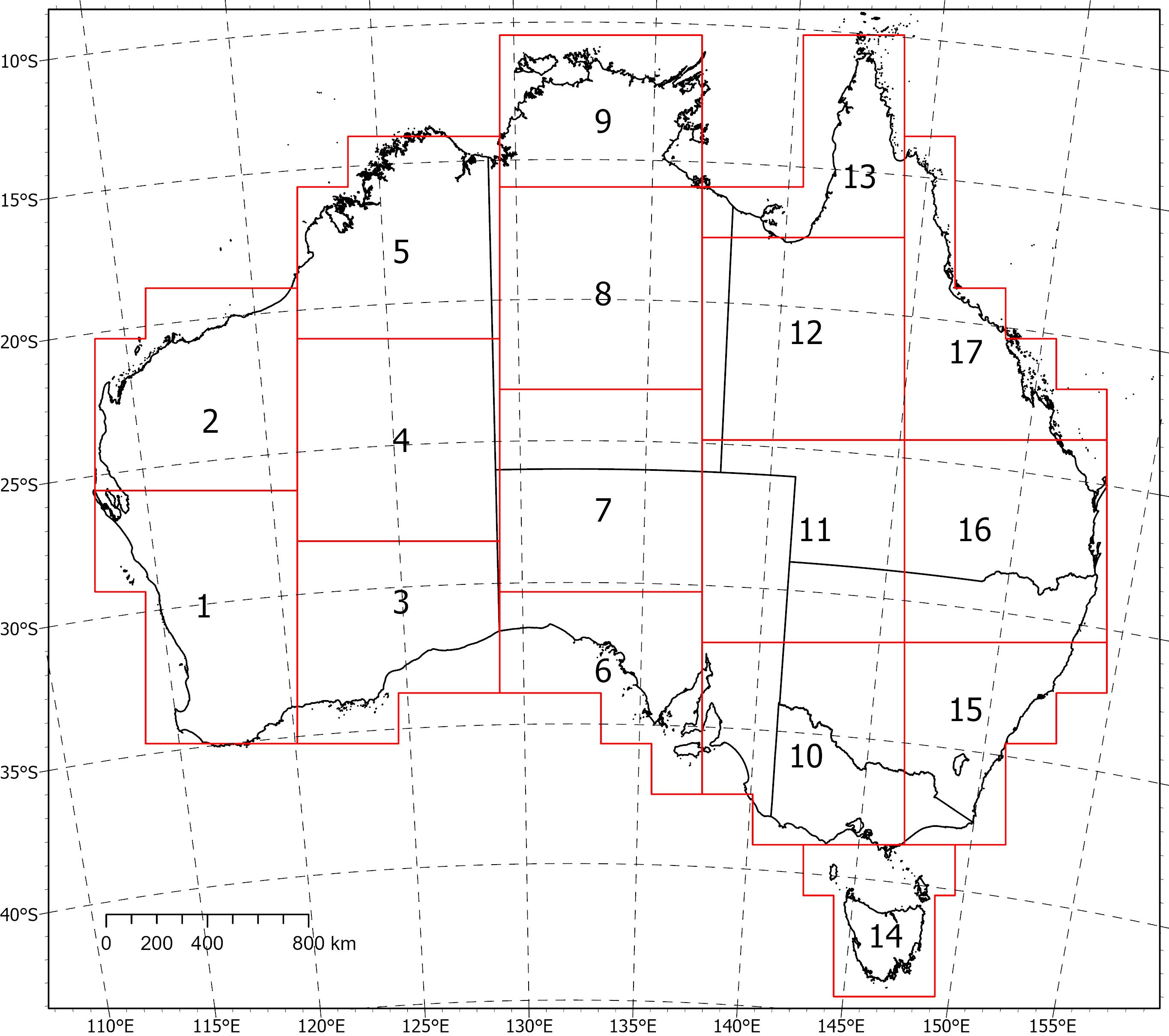
Two coincident, crustal-scale models, one of magnetic susceptibility and one of density, have been produced for a volume covering the Australian continent and extending down to 55.5 km depth. These models were produced using the UBC GIF MAG3D and GRAV3D inversion programs, respectively. The inversions were constrained with geological reference models with layers for sediments, undifferentiated crust and the mantle. The reference model for the magnetic inversion incorporated a Curie depth surface below which magnetic susceptibility was set to zero. Due to the size of the inversion problem to be solved, the volume was divided into 235 overlapping inversions, which were inverted separately and then recombined. The method of recombining the inversions relies on a cosine function to determine the weight of each property and then takes a weighted average. This method successfully attenuated the edge effects that would otherwise occur between models and allows them to be viewed as one seamless model that covers the whole of Australia. Regions of coincident high-density (>2.83 g/cm<sup>3</sup>) and high-magnetic susceptibility (>0.0125 SI) within the top 10 km of the undifferentiated crust (termed magnetite proxies) are suggested to be related to ultramafic rocks and the magnetite-forming hydrothermal alteration stages of potentially fertile IOCG systems (see download link: Magnetite region grids) . <b>Download Link & Description</b> <b>•</b> GA Record (.pdf) - The report describing the method and model results. PDF document. <b>•</b> Intermediate grids (.ers) - The Australia-wide intermediate grids of elevation, gravity, and total magnetic intensity. ERMapper (.ers) format. <b>•</b> Magnetite region grids (.ers, .tif) - The Australia-wide magnetite proxy regions projected onto a 2D surface. ERMapper (.ers) and GeoTiff (.tif) format. <b>•</b> Subset_[1-17] (.sg, .den, .sus) - The Australia-wide 3D density and magnetic susceptibility models in SGrid (.sg) and UBC-GIF (.den, .sus) formats. Also includes the geological reference model surfaces (.ts). <b>•</b> Individual inversion files - GRAV3D and MAG3D input and output files for the 235 individual UBC-GIF inversions (before being recombined using cosine weighting). <b>Individual inversion input/output files for A1-V2 are available on request from clientservices@ga.gov.au - Quote eCat# 149226</b> Due to their size, the Australia-wide models have been divided into subsets (labelled 1-17) for download. Please refer to the image below for the extent of the subsets.
-
This service provides Estimates of Geological and Geophysical Surfaces (EGGS). The data comes from cover thickness models based on magnetic, airborne electromagnetic and borehole measurements of the depth of stratigraphic and chronostratigraphic surfaces and boundaries.
-
<div>This report contains information about the operation of Geoscience Australia’s ten permanent geomagnetic observatories, repeat stations and other relevant information covering the period from 2017 to 2021.</div><div>Information regarding the activities and services of Geoscience Australia’s Geomagnetism program, distribution of geomagnetic data, geomagnetic instrumentation and data processing procedures is also provided.</div><div><br></div>
-
Survey Name: East Tasmania Datasets Acquired: Magnetics, Radiometrics and Elevation Geoscience Australia Project Number: P5020 Acquisition Start Date: 20/03/2022 Acquisition End Date: 23/06/2022 Flight line spacing: 200 m Flight line direction: East-West (090-270) Total distance flown: 57,709 line-km's Nominal terrain clearance: 80 m Data Acquisition: Magspec Airborne Surveys Pty Ltd Project Management: Geoscience Australia Quality Control: Geoscience Australia Dataset Ownership: Geoscience Australia and Mineral Resources Tasmania Datum: Geocentric Datum of Australia 2020 (GDA2020) Projection: Map Grid of Australia 55 (MGA55) Included in this release: 1. Point-located Data - ASCII-column (.dat) or NetCDF (.nc) format. • Magnetic diurnal; • Magnetics raw-edited; • Magnetics reduced; • Radiometrics raw-edited; • Radiometrics reduced. 2. Gridded data - ERMapper (.ers) format. • Total magnetic intensity (TMI); • TMI reduced to pole (RTP); • TMI RTP with first vertical derivative (1VD) applied; • Dose rate (with NASVD and standard processing); • Potassium concentration (with NASVD, standard processing); • Thorium concentration (with NASVD, standard processing); • Uranium concentration (with NASVD, standard processing); • Radar-derived digital elevation model (geoidal). 3. Reports. • Calibration report; • Operations and processing summary report. © Commonwealth of Australia (Geoscience Australia) and Mineral Resources Tasmania, Government of Tasmania 2022. With the exception of the Commonwealth Coat of Arms and where otherwise noted, this product is provided under a Creative Commons Attribution 4.0 International Licence (http://creativecommons.org/licenses/by/4.0/legalcode).
-
Over 8,200 line kilometres of gravity and magnetic data, acquired during the 2020 Otway Basin Seismic Program (OBSP), were combined with public domain survey and satellite data to produce seamless maps of the NW-SE trending deep-water Otway Basin. These data provide valuable information on the geometry and spatial extent of igneous rocks in the deep-water basin. While the top of basement can effectively be imaged from seismic reflection datasets onshore in the Otway Basin, it remains problematic in parts of the deep-water offshore region due to variable seismic data quality. Modelling of the magnetic line data provides an estimate of the depth to the top of basement, an important interface for understanding hydrocarbon prospectivity because it plays a key role in characterising the tectonic evolution of the basin, and thus the thermal maturation history of hydrocarbons. Magnetic modelling was performed using a profile-based curve matching technique producing a depth estimate to the top of the magnetic body that is assumed to be the top of the basement. However, this assumption is flawed where there are volcanic or igneous intra-sedimentary rocks in the basin, as is the case for the Otway Basin where the interpretation of seismic reflection data shows highly reflective events corresponding to igneous features. In most parts of the basin, the modelling results show two layers: a shallow layer (depths < 1000m) corresponding to near surface volcanics, and a deeper layer (depths > 1000m) attributed to the top of the magnetic basement. Magnetic basement shows some similarities with basement picked on seismic reflection data, though in some areas the magnetic basement is shallower. The results also show that the depth to basement is not well resolved in areas with abundant intra-sedimentary igneous rocks. Further investigation is needed in such areas. Presented at the 2024 Australian Society of Exploration Geophysicists (ASEG) Discover Symposium