Darling-Curnamona-Delamerian
Type of resources
Keywords
Publication year
Topics
-
The Exploring for the Future program Showcase 2024 was held on 13-16 August 2024. Day 4 - 16th August talks included: <b>Session 1 – Deep Dives into the Delamerian</b> <a href="https://youtu.be/09knAwPnD7s?si=acdu6pQgIj7DNlnj">Scaffold to success: An overview of the Delamerian Orogen, and its crustal and lithospheric architecture</a> - Chris Lewis <a href="https://youtu.be/5GQC5f5IkWc?si=rLPqxoZFkxGAEPEf">Only time will tell: Crustal development of the Delamerian Orogen in space and time</a> - David Mole <a href="https://youtu.be/PhdIYE49eqU?si=d7acyv5rbTW_wTiO">Is it a big deal? New mineral potential insights of the Delamerian Orogen</a> - Dr Yanbo Cheng <b>Session 2 – Deep dives into Birrindudu, West Musgrave and South Nicholson–Georgina regions</b> <a href="https://youtu.be/DEbkcgqwLE8?si=sBKGaMTq_mheURib">Northwest Northern Territory Seismic Survey: Resource studies and results</a> - Paul Henson <a href="https://youtu.be/k9vwBa1fM9E?si=VOG19nBC1DAk-jGH">Tracing Ancient Rivers: A hydrogeological investigation of the West Musgrave Region</a> - Joshua Lester <a href="https://youtu.be/Du1JANovz8M?si=1XEOF87gxhSP9UF3">Water's journey: Understanding groundwater dynamics in the South Nicholson and Georgina basins, NT and QLD </a>- Dr Prachi Dixon-Jain <b>Session 3 – Groundwater systems of the Curnamona and upper Darling-Baaka River</b> <a href="https://youtu.be/nU8dpekmEHQ?si=WygIzefKNzsU4gUA">Groundwater systems of the upper Darling-Baaka floodplain: An integrated assessment</a> - Dr Sarah Buckerfield <a href="https://youtu.be/AKOhuDEPxIA?si=ebradAT6EBwHhPQ_">Potential for a Managed Aquifer Recharge Scheme in the upper Darling-Baaka floodplain: Wilcannia region</a> - Dr Kok Piang Tan <a href="https://youtu.be/epUdD8ax2FQ?si=_aMO_e_ZDZESgLOR">Aquifer alchemy: Decoding mineral clues in the Curnamona region</a> - Ivan Schroder Exploring for the Future: Final reflection – Karol Czarnota Resourcing Australia’s Prosperity – Andrew Heap View or download the <a href="https://dx.doi.org/10.26186/149800">Exploring for the Future - An overview of Australia’s transformational geoscience program</a> publication. View or download the <a href="https://dx.doi.org/10.26186/149743">Exploring for the Future - Australia's transformational geoscience program</a> publication. You can access full session and Q&A recordings from YouTube here: 2024 Showcase Day 4 - Session 1 - <a href="https://www.youtube.com/watch?v=4nuIQsl71cY">Deep Dives into the Delamerian</a> 2024 Showcase Day 4 - Session 2 - <a href="https://www.youtube.com/watch?v=9N3dIZRAcHk">Deep dives into Birrindudu, West Musgrave and South Nicholson–Georgina regions</a> 2024 Showcase Day 4 - Session 3 - <a href="https://www.youtube.com/watch?v=_ddvLAnUdOI">Groundwater systems of the Curnamona and upper Darling-Baaka River</a>
-
<div><strong>Output Type: </strong>Exploring for the Future Extended Abstract</div><div><br></div><div><strong>Short Abstract: </strong>Communities and ecosystems along the Darling-Baaka River have been impacted by critical water shortages and water quality issues including high salinity, algal blooms, and fish kills due to declining surface water flows. The river is characterised by naturally highly variable flows and is the primary water source for the region, but extraction and a meteorological drying trend associated with climate change have caused declines in discharge of 53–73% since the advent of post-settlement agriculture and industry. Understanding of the spatial extent, quality, and useability of lower salinity groundwater within the surrounding Darling Alluvium, which could provide an alternative and potentially more sustainable water source, was previously limited. Here we present the findings of an integrated study combining modelled ground and airborne geophysical data, groundwater and surface water levels, hydrochemistry, lithology, and remote sensing data to delineate groundwater systems and understand the geological and hydrological controls on their occurrence. The resolution and breadth of datasets acquired and collated permit mapping of the key factors controlling occurrence and quality of groundwater aquifers, namely basement topography and hydrostratigraphy, groundwater-surface water dynamics, and inter-aquifer connectivity. On this basis the study area can be sub-divided into regions with distinctive aquifer distribution and quality, recharge mechanisms, and pressure gradients between aquifers. We also showed that the groundwater levels in the unconfined aquifer have declined, an expected outcome of the decline in discharge in the Darling-Baaka River which forms the primary recharge mechanism for the alluvial aquifers. These outputs have direct implications for key management questions including location and quantity of potentially useable groundwater, risk of saline groundwater up-coning or discharging to the river, and likelihood of groundwater extraction impacting river flows and groundwater dependent ecosystems. </div><div><br></div><div><strong>Citation: </strong>Buckerfield, S., McPherson, A., Tan, K.P., Walsh, C., Buchanan, S., Kilgour, P., Suckow, A., Raiber, M., Symington, N. & Pincus, J., 2024. Groundwater systems of the Upper Darling-Baaka River Floodplain. In: Czarnota, K. (ed.) Exploring for the Future: Extended Abstracts. Geoscience Australia, Canberra. https://doi.org/10.26186/149718</div>
-
<div>The Darling-Curnamona-Delamerian (DCD) project focused on the covered portion of the Delamerian orogen, situated in the south-eastern mainland states of Australia. The aims of the project were to develop a greater understanding of the geodynamic history of the Delamerian Orogen, characterise known magmatic-hydrothermal mineral systems, and assess mineral potential for a suite of minerals including copper (Cu), gold (Au), and nickel (Ni), and critical minerals like platinum-group elements (PGEs) and rare-earth elements (REEs). </div><div>Here, we collate whole rock geochemistry data from new and legacy samples of mafic to intermediate magmatic rocks of the Loch Lilly-Kars Belt in order to determine the likely source of these magmas and constrain the prevailing tectonic setting during their emplacement. We apply multi-elemental diagrams and various elemental discrimination diagrams to characterise various groups of magmatic rocks in these belts, taking into account their geographic affinity and new geochronological data (e.g. Mole et al., 2023; Mole et al., 2024). The geochemical characteristics of these groups and the implications for the tectonic setting into which they were emplaced are discussed. Comparisons are made with potentially similar magmatic rocks of the Koonenberry Belt and Grampians-Stavely Zone. Results from this study have significant implications for the tectonic setting in which the Loch Lilly-Kars Belt developed, and hence also the mineral potential of the Belt. </div><div> </div>
-
Geoscience Australia’s Exploring for the Future program provides precompetitive information to inform decision-making by government, community and industry on the sustainable development of Australia's mineral, energy and groundwater resources. By gathering, analysing and interpreting new and existing precompetitive geoscience data and knowledge, we are building a national picture of Australia’s geology and resource potential. This leads to a strong economy, resilient society and sustainable environment for the benefit of all Australians. This includes supporting Australia’s transition to a low emissions economy, strong resources and agriculture sectors, and economic opportunities and social benefits for Australia’s regional and remote communities. The Exploring for the Future program, which commenced in 2016, is an eight-year, $225m investment by the Australian Government. The Darling-Curnamona-Delamerian (DCD) 2D reflection seismic survey was acquired during May to August 2022 in the Delamerian Orogen, the Murray-Darling basin, the Curnamona Province, and the upper Darling River floodplain regions in South Australia, Victoria and New South Wales. This project is a collaboration between Geoscience Australia (GA), the Geological Survey of South Australia (GSSA), the Geological Survey of Victoria (GSV) and the Geological Survey of New South Wales (GSNSW) and was funded by the Australian Government’s Exploring for the Future (EFTF) program. The overall objective of the EFTF Darling-Curnamona-Delamerian project is to improve the understanding of mineral and groundwater resources of the Curnamona Province and Delamerian Orogen and overlying basin systems through acquisition and interpretation of new pre-competitive geoscience data sets. The total length of acquisition was 1256 km distributed over five deep crustal 2D reflection seismic lines 22GA-DL1 (446 km), 22GA-DL2 (249 km), 22GA-CD1 (287 km), 22GA-CD2 (178 km), 22GA-CD3 (39.5 km) to image deep crustal structures, and a high-resolution 2D reflection seismic line 22GA-UDF (56 km) to explore groundwater resources. The DL lines provide coverage of fundamental geophysical data over the Flinders Range, the Delamerian Province and the Murray-Darling basin region in eastern South Australia and Victoria. The CD lines extend through the Curnamona Province and into the Darling Basin. The UDF line will assist with refining the hydrogeological model, understanding groundwater dynamics, and locating areas better suited to groundwater bores for better quality groundwater in the upper Darling River floodplain area. The data processing was performed by a contractor under the supervision of Geoscience Australia. The five deep crustal lines (22GA-DL1,DL2,CD1,CD2,CD3) were processed with record lengths of 20 and 8 seconds, while the shallow high-resolution line (22GA-UDF) was processed at a 4 second length. This processing yielded DMO Stack, Post-Stack Time Migration, and Pre-Stack Time Migration products. <strong>Raw shot gathers and processed gathers for this survey are available on request from clientservices@ga.gov.au - Quote eCat# 147423</strong>
-
The Exploring for the Future program Showcase 2023 was held on 15-17 August 2023. Day 2 - 16th August talks included: Highways to Discovery and Understanding Session AusAEM - Unraveling Australia's Landscape with Airborne Electromagnetics – Dr Yusen Ley Cooper Exploring for the Future Data Discovery Portal: A scenic tour – Simon van der Wielen Towards equitable access to regional geoscience information– Dr Kathryn Waltenberg Community engagement and geoscience knowledge sharing: towards inclusive national data and knowledge provision – Dr Meredith Orr Foundational Geoscience Session The power of national scale geological mapping – Dr Eloise Beyer New surface mineralogical and geochemical maps of Australia – Dr Patrice de Caritat Imaging Australia’s Lithospheric Architecture – Dr Babak Hejrani Metallogenic Potential of the Delamerian Margin– Dr Yanbo Cheng You can access the recording of the talks from YouTube here: <a href="https://youtu.be/ZPp2sv2nuXI">2023 Showcase Day 2 - Part 1</a> <a href="https://youtu.be/dvqP8Z5yVtY">2023 Showcase Day 2 - Part 2</a>
-
<div>This report presents key results from the Upper Darling River Floodplain groundwater study conducted as part of the Exploring for the Future (EFTF) program in north-western New South Wales. The Australian Government funded EFTF program aimed to improve understanding of potential mineral, energy, and groundwater resources in priority areas for each resource.</div><div><br></div><div>The Upper Darling River Floodplain study area is located in semi-arid zone northwest New South Wales is characterised by communities facing critical water shortages and water quality issues, along with ecosystem degradation. As such, there is an imperative to improve our understanding of groundwater systems including the processes of inter-aquifer and groundwater-surface water connectivity. The key interest is in the fresh and saline groundwater systems within alluvium deposited by the Darling River (the Darling alluvium - DA) which comprises sediment sequences from 30 m to 140 m thick beneath the present-day floodplain.</div><div><br></div><div>The study acquired airborne, surface and borehole geophysical data plus hydrochemical data, and compiled geological, hydrometric, and remote sensing datasets. The integration of airborne electromagnetic (AEM) data with supporting datasets including surface and borehole magnetic resonance, borehole induction conductivity and gamma, and hydrochemistry data has allowed unprecedented, high resolution delineation of interpreted low salinity groundwater resources within the alluvium and highly saline aquifers which pose salination risk to both the river and fresher groundwater. Improved delineation of the palaeovalley architecture using AEM, seismic, and borehole datasets has permitted interpretation of the bedrock topography forming the base of the palaeovalley, and which has influenced sediment deposition and the present-day groundwater system pathways and gradients.</div><div><br></div><div>The integrated assessment demonstrates that the alluvial groundwater systems within the study area can be sub-divided on the basis of groundwater system characteristics relevant to water resource availability and management. Broadly, the northern part of the study area has low permeability stratigraphy underlying the river and a generally upward groundwater gradient resulting in limited zone of freshwater ingress into the alluvium around the river. A bedrock high south of Bourke partially restricts groundwater flow and forces saline groundwater from deeper in the alluvium to the surface in the vicinity of the Upper Darling salt interception scheme. From approximately Tilpa to Wilcannia, sufficiently permeable stratigraphy in hydraulic connection with the river and a negligible upward groundwater gradient allows recharge from the river, creating significant freshwater zones around the river within the alluvium.</div><div><br></div><div>Hydrometric and hydrochemical tracer data demonstrate that the alluvial groundwater systems are highly coupled with the rivers. Results support the conceptual understanding that bank-exchange processes and overbank floods associated with higher river flows are the primary recharge mechanism for the lower salinity groundwater within the alluvium. When river levels drop, tracers indicative of groundwater discharge confirm that groundwater contributes significant baseflow to the river. Analysis of groundwater levels and surface water discharge indicates that the previously identified declining trends in river discharge are likely to produce the significant decline in groundwater pressure observed across the unconfined aquifer within the alluvium. Improved quantification and prediction of groundwater-surface water connectivity, water level and flux is considered a high priority for both the Darling River and the wider Murray–Darling Basin. This information will assist in understanding and managing water resource availability in these highly connected systems, and enhance knowledge regarding cultural values and groundwater dependent ecosystems (GDEs).</div><div><br></div><div>This study identifies several aquifers containing groundwater of potentially suitable quality for a range of applications in the south of the study area between Wilcannia and Tilpa and assessed the geological and hydrological processes controlling their distribution and occurrence. Potential risks associated with the use of this groundwater, such as unsustainable extraction, impacts on GDEs, and saline intrusion into aquifers or the river, are outside the scope of this work and have not been quantified.</div>
-
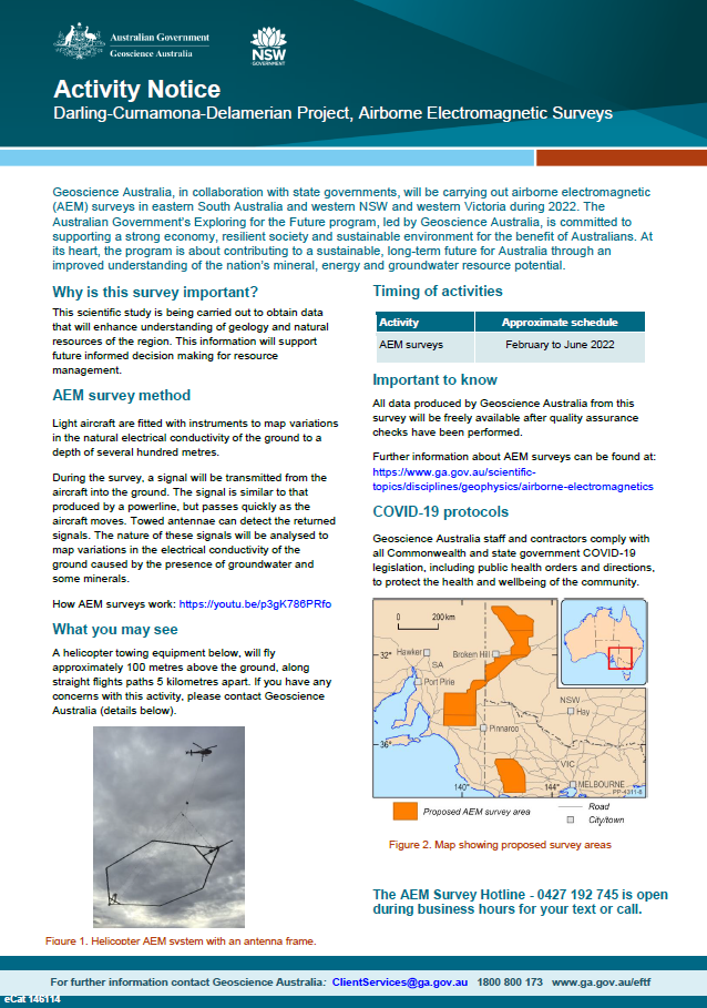
Geoscience Australia, in collaboration with state governments, will be carrying out airborne electromagnetic (AEM) surveys in eastern South Australia and western NSW and Victoria during 2022. The Australian Government’s Exploring for the Future program, led by Geoscience Australia, is committed to supporting a strong economy, resilient society and sustainable environment for the benefit of Australians. At its heart, the program is about contributing to a sustainable, long-term future for Australia through an improved understanding of the nation’s mineral, energy and groundwater resource potential <p>
-
As part of the program, the Darling-Curnamona-Delamerian project is investigating the groundwater potential of the upper Darling River floodplain, as well as the mineral and groundwater potential of parts of eastern South Australia, western New South Wales, western Victoria and western Tasmania. Communities, industries and the environment in the upper Darling River region have been impacted by recent droughts. During periods of low flow in the Darling River, groundwater has the potential to be an alternative water source for towns, agriculture and mining. The aim of the Upper Darling River Floodplain Groundwater study is to identify and better understand groundwater supplies beneath the floodplain and its surrounds. When combined with innovative water storage options, these groundwater resources could provide enhanced drought security and promote regional development. The study area covers ~31,000 km2 and includes a 450 km stretch of the Darling River floodplain from Wilcannia upstream to Bourke and Brewarrina.
-
<div><strong>Output type: </strong>Exploring for the Future Extended Abstract </div><div><br></div><div><strong>Short Abstract: </strong>The Delamerian Orogen, with a length of ~1000 km on mainland Australia and a proven potential to host mineralisation, represents an evolving exploration opportunity. However, uncertainty surrounding the age and tectonic setting of the orogen is a barrier to confident exploration in frontier covered regions, such as the Loch Lilly-Kars Belt in western New South Wales and South Australia. A major area of uncertainty is the configuration and extent of the Cambrian convergent-margin system and lateral variations thereof. In this study, we highlight multidisciplinary data from new and legacy sources, including lithology, geochronology, geochemistry, potential-field geophysics, deep-crustal seismic, and magnetotelluric data that permit a revised interpretation of the geological framework for the Delamerian Orogen in mainland Australia, with an emphasis on the covered, central part of the system. These data indicate that a largely continuous, east-facing volcanic arc developed in the Delamerian Orogen in the Cambrian. The arc transitions from exhibiting a strong continental affinity in the Koonenberry Belt to having less continental affinity in the Grampians-Stavely Zone of Victoria. The Loch Lilly-Kars Belt is interpreted to have occupied a volcanic arc to incipient back-arc position in the middle Cambrian. </div><div><br></div><div><strong>Citation: </strong>Clark A.D., et al., 2024. Cambrian convergent margin configuration in the Delamerian Orogen of mainland Australia. In: Czarnota, K. (ed.) Exploring for the Future: Extended Abstracts, Geoscience Australia, Canberra, https://doi.org/10.26186/149647 </div>
-
<div><strong>Output type: </strong>Exploring for the Future Extended Abstract</div><div><br></div><div><strong>Short abstract: </strong> Crustal architecture provides first order controls on the distribution of mineral resources of an area and is best imaged by deep seismic reflection data. Here we present a first interpretation of seismic line 22GA-CD2, acquired as part of the Darling-Curnamona-Delamerian (DCD) project. Line 22GA-CD2 images the central eastern Delamerian Orogen, where basement rocks are concealed by the Murray Basin. Key findings include: (i) the crustal architecture preserves many characteristics of the early evolution of west-dipping Delamerian subduction, accretion and orogeny between ~ 515 Ma - 495 Ma. This initial configuration has been reworked and reactivated during younger orogenic events; (ii) the lower and middle crust constitutes the newly defined Barrier Seismic Province, which is also imaged in legacy seismic reflection line 05GA-TL1 and interpreted to continue northeast to the Olepoloko Fault; (iii) a similar seismic character to that of the Barrier Seismic Province has been observed in legacy seismic reflection lines in Victoria and related to a Cambrian accretionary setting and adjacent foreland; (iv) the present-day upper crustal configuration is largely the result of contractional fault reactivation, with significant vertical movements during the Kanimblan-Alice Springs Orogeny (~ 360 Ma - 340 Ma); (v) a large area of prospective rocks for mineral deposits with Cambrian arc-affiliation are accessible to exploration under shallow cover of the Murray Basin (often less than 200 m).</div><div> </div><div><strong>Citation: </strong>Doublier M.P., et al., 2024. Crustal architecture along seismic line 22GA-CD2: new insights from the Darling-Curnamona-Delamerian deep seismic reflection survey. In: Czarnota, K. (ed.) Exploring for the Future: Extended Abstracts, Geoscience Australia, Canberra, https://dx.doi.org/10.26186/149658</div>