dating
Type of resources
Keywords
Publication year
Topics
-
The Lower Darling Valley (LDV) contains Cenozoic shallow marine, fluvial, lacustrine and aeolian sediments capped by a number of Quaternary fluvial units associated with the Darling River and its anabranches, which were poorly dated prior to this study. Recent investigations in the LDV area have used an Airborne Electromagnetic (AEM) survey, a new high-resolution LiDAR survey, sonic drilling, shallow hand-augering, examination of tractor-dug pits, sediment sample analyses, landform mapping, and river bottom profiling in combination with OSL and radiocarbon dating to provide new insights into the nature and chronology of Quaternary fluvial landscape evolution. The Quaternary sequence in the LDV consists of scroll-plain tracts of different ages incised into higher, older and more featureless floodplain sediments. Samples for OSL and radiocarbon dating were taken in tractor-excavated pits, from sonic cores and from hand-auger holes from a number of scroll-plain and older floodplain sediments. The youngest, now inactive, scroll-plain phase associated with the modern Darling River, was active in the period 5-2 ka. A previous anabranch scroll-plain phase has Last Glacial Maximum dates around 20 ka. Less distinct scroll-plain tracts, older than the anabranch system, have ages around 30ka. A poorly preserved scroll-plain phase with very indistinct scroll and channel traces is associated with the Darling River tract and has ages around 45-50 ka. Older dates of 85 ka and >150 ka have been obtained beneath the higher floodplain from lateral-migration sediments that lack visible scroll-plain traces. This chronologic sequence suggests regular recurrence of approximately 5 ka lateral-migration episodes separated by approximately 10 ka periods of quiescence. There is a lack of coincidence with the glacial-interglacial climate cycles. This suggests that the onset and termination of lateral-migration phases is probably a combination of changes in discharge and sediment regimes r
-
The Gawler Craton, South Australia, preserves extensive sedimentary sequences and associated magmatic rocks that span the interval covering the Archaean-Palaeoproterozoic transition, with bimodal calc-alkaline volcanism and associated sedimentation occurring over the interval ~2560-2480 Ma. The pervasive high geothermal gradient metamorphism in the earliest Palaeoproterozoic, ~2470-2420 Ma (Fanning et al., 2007; Jagodzinski et al., 2009) within the Gawler Craton suggests the Gawler Craton is potentially more likely a correlative of the Dhawaar Craton, Sask Craton and other similar terranes, in terms of timing of magmatic and orogenic events (Payne et al., 2009). We report new zircon U-Pb ion probe data collected from Neoarchaean to Earliest Palaeoproterozoic metasedimentary and meta-igneous rocks of the Gawler Craton, South Australia, an important time interval for the development of the Gawler Craton itself that has been investigated by relatively few geochronological studies. The new data show that the interval ~2560-2480 Ma was characterised by deposition and associated magmatism. This was terminated by contractional deformation and high geothermal gradient metamorphism over the interval ~2470-2410 Ma.
-
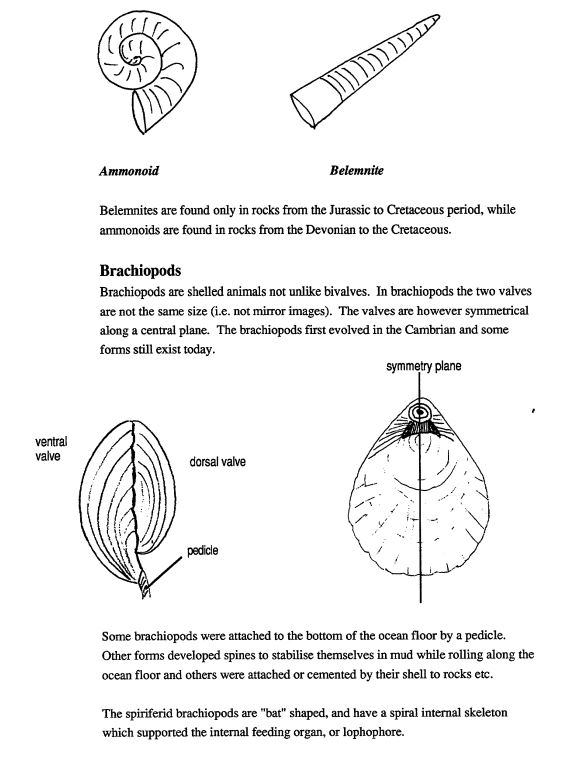
This black and white education resource is a 58 page booklet which contains information on geological time, fossilisation, characteristics of major groups of vertebrate and invertebrates, micropaleontology (e.g.. spores and pollen), trace fossils and the uses of fossils. It includes student activities. Suitable for secondary Years 7-10
-
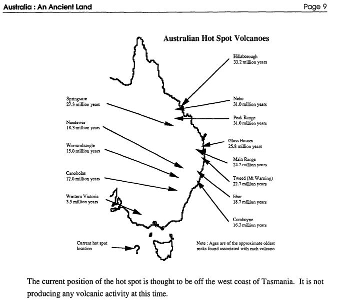
This black and white resource is an 18 page booklet including geological time, rock clocks, the age of famous Australian places, Australia on the move, Australian volcanoes, Ice Ages, Ancient Australian life, how fossils form and some common Australian fossils. Includes student activities suitable for primary Years K-6.
-
The Ranger deposit is one of Australia's largest known uranium resources, with current open pit mining of the No. 3 orebody and a total resource of 109,600 tonnes of U3O8 grading 0.08% at this orebody (ERA, January 2011). This unconformity-related deposit is hosted by Paleoproterozoic metasedimentary rocks of the Cahill Formation which is unconformably overlain by sandstones of the Kombolgie Formation. A maximum depositional age of ~1818 Ma is inferred for the sandstones, based on the presence of the Nabarlek Granite of this age in the basement beneath the Kombolgie Formation. Most mineralisation occurs within a largely stratabound shear and breccia zone and is associated with intense proximal chlorite and distal white mica alteration. The Kombolgie Formation is weakly deformed, faulted and weakly chloritised above the mineralisation.
-
No abstract available
-
This set of four charts provide an update of the million year numbers assigned to Australian palynological zone boundaries to the latest Geologic Time Scale 2004, authored by Gradstein et al. (2004), over the geological time interval Jurassic to Recent. These charts have been drafted to help display the relationships of the palynological zones to the new timescale and to assist in scaling the zones and subzones, so that most million year ages assigned to the zone boundaries are mostly numbers with not more than one decimal place.
-
Recent centuries provide no precedent for the 2004 Indian Ocean tsunami, either on the coasts it devastated or within its source area. The tsunami claimed nearly all of its victims on shores that had gone 200 years or more without a tsunami disaster. The associated earthquake of magnitude 9.2 defied a Sumatra-Andaman catalogue that contains no nineteenth-century or twentieth-century earthquake larger than magnitude 7.9. The tsunami and the earthquake together resulted from a fault rupture 1,500 km long that expended centuries -worth of plate convergence. Here, using sedimentary evidence for tsunamis, we identify probable precedents for the 2004 tsunami at a grassy beach-ridge plain 125 km north of Phuket. The 2004 tsunami, running 2 km across this plain, coated the ridges and intervening swales with a sheet of sand commonly 5-20 cm thick. The peaty soils of two marshy swales preserve the remains of several earlier sand sheets less than 2,800 years old. If responsible for the youngest of these pre-2004 sand sheets, the most recent full-size predecessor to the 2004 tsunami occurred about 550-700 years ago.
-
2004 updated version of Helby, Morgan & Partridge (1987)
-
The geological evolution of Australia is closely linked to supercontinent cycles that have characterised the tectonic evolution of Earth, with most geological and metallogenic events relating to the assembly and breakup of Vaalbara, Kenorland, Nuna, Rodinia and Pangea-Gondwana. Australia largely grew from west to east, with two major Archean cratons, the Yilgarn and Pilbara Cratons, forming the oldest part of the continent in the West Australian Element. The centre consists mostly of the largely Paleo-to Mesoproterozoic North and South Australian Elements, whereas the east is dominated by the Phanerozoic-Mesozoic Tasman Element. The West, North and South Australian Elements initially assembled during the Paleoproterozoic amalgamation of Nuna, and the Tasman Element formed as a Paleozoic accretionary margin during the assembly of Gondwana-Pangea. Australia's present position as a relatively stable continent resulted from the break-up of Gondwana. Australia is moving northward toward southeast Asia, probably during the earliest stages of the assembly of the next supercontinent, Amasia. Australia's resources, both mineral and energy, are linked to its tectonic evolution and the supercontinent cycle. Clusters of resources, both in space and time, are associated with Australia's tectonic history and the Earth's supercontinent cycles. Australia's most important gold province is the product of the assembly of Kenorland, whereas its major zinc-lead-silver deposits and iron-oxide-copper-gold deposits formed as Nuna broke up. The diverse metallogeny of the Tasman Element is a product of Pangea-Gondwana assembly and most of Australia's hydrocarbon resources are a consequence of the break-up of this supercontinent.


