Tasmania
Type of resources
Keywords
Publication year
Topics
-
Survey Name: Tasmanian Tiers Datasets Acquired: Magnetics, Radiometrics and Elevation Geoscience Australia Project Number: P5003 Acquisition Start Date: 10/02/2021 Acquisition End Date: 02/04/2021 Flight line spacing: 200 m Flight line direction: East-West (090-270) Total distance flown: 33,019 line-km Nominal terrain clearance: 80 m Blocks: 5 Data Acquisition: Magspec Airborne Surveys Project Management: Geoscience Australia Quality Control: Geoscience Australia Dataset Ownership: Mineral Resources Tasmanian and Geoscience Australia Included in this release: 1. Point-located Data ASCII-column data with accompanying description and definition files. • Magnetics corrected i. Magnetic data with corrections for diurnal, IGRF, tie-levelling, micro-levelling. ii. Elevation data converted to geoidal values and a digital elevation model. • Radiometrics corrected i. Equivalent ground concentrations of radioelements with NASVD spectral filtering and standard IAEA processing. 2. Grids Gridded data in ERMapper (.ers) format (GDA2020, MGA55). • Total magnetic intensity (TMI). • TMI reduced to pole (RTP). • TMI RTP with first vertical derivative applied. • Dose rate (with NASVD and standard processing). • Potassium concentration (with NASVD, standard processing, 3D topographic correction). • Thorium concentration (with NASVD, standard processing, 3D topographic correction). • Uranium concentration (with NASVD, standard processing, 3D topographic correction). • Laser-derived digital elevation model (geoidal). • Radar-derived digital elevation model (geoidal). 3. Outlines (survey extents) • Polygon outlines showing the extent of each block and the entire survey in ArcGIS shapefile format (GDA2020, MGA55). 4. Reports • P5003_3D_topographic_correction_of_gamma_ray_data.pdf i. Details of the 3D topographic corrections applied to the radiometric data. • P5003_calibration_report_fixed_wing.pdf i. Details of the calibration performed on the fixed wing aircraft (block 1). • P5003_calibration_report_helicopter.pdf i. Details of the calibration performed on the helicopter (blocks 2-5). • P5003_operations_and_processing_report.pdf i. Summary of the data acquisition and processing. © Mineral Resources Tasmania, Government of Tasmania and Commonwealth of Australia (Geoscience Australia) 2021. With the exception of the Commonwealth Coat of Arms and where otherwise noted, this product is provided under a Creative Commons Attribution 4.0 International Licence. (http://creativecommons.org/licenses/by/4.0/legalcode).
-
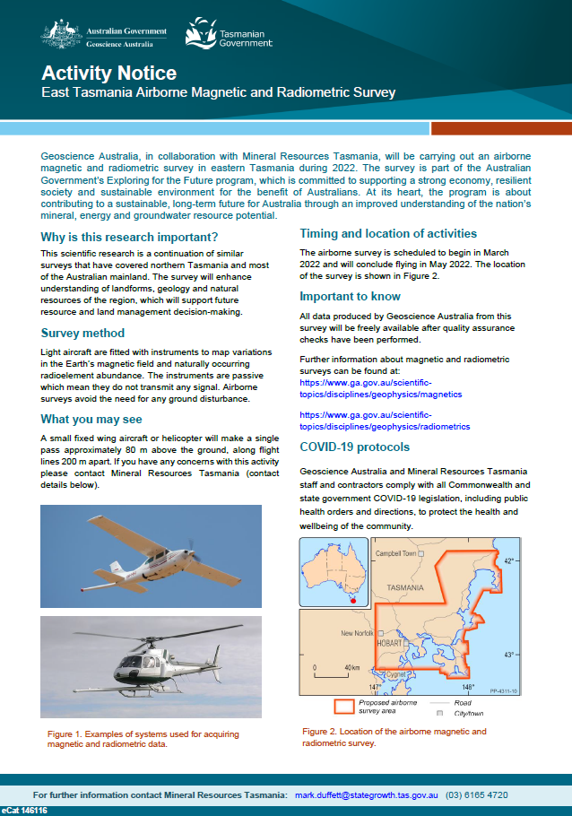
Geoscience Australia, in collaboration with Mineral Resources Tasmania, will be carrying out an airborne magnetic and radiometric survey in eastern Tasmania during 2022. The survey is part of the Australian Government’s Exploring for the Future program, which is committed to supporting a strong economy, resilient society and sustainable environment for the benefit of Australians. At its heart, the program is about contributing to a sustainable, long-term future for Australia through an improved understanding of the nation’s mineral, energy and groundwater resource potential. <p>
-
<div>We performed an earthquake risk assessment of the state of Tasmania through a collaboration between the Tasmania Department of State Growth and Geoscience Australia with geotechnical and geological support from Mineral Resources Tasmania (MRT). We developed local surface earthquake hazard maps for Tasmania, focusing on the twenty largest communities, based on the 2018 National Seismic Hazard Assessment and seismic site conditions map for Australia augmented by geotechnical information provided by MRT. For the building exposure database, the National Exposure Information System was augmented with an engineering survey of Hobart central business district (CBD) undertaken by GA. We used GA’s current vulnerability functions including a range of models for high-risk unreinforced masonry buildings (URM). With a focus on the Hobart CBD, retrofit measures were applied to the URM building types in order to quantify the effectiveness of mitigation. This study provided a synoptic state-wide view that enabled the identification of communities of high risk and low resilience by combining the damage related risk with the Australian Disaster Resilience Index. In addition, three earthquake scenario events centred on Hobart were modelled along with the impact reduction achieved through a virtual retrofit of old URM buildings in the Hobart CBD. </div><div><br></div>This paper was presented to the 2022 Australian Earthquake Engineering Society (AEES) Conference 24-25 November (https://aees.org.au/aees-conference-2022/)
-
<div>This dataset represents the second version of a compilation of borehole stratigraphic unit data on a national scale (Figure 1). It builds on the previous Australian Borehole Stratigraphic Units Compilation (ABSUC) Version 1.0 (Vizy & Rollet, 2023a) with additional new or updated stratigraphic interpretation on key boreholes located in Figure 2. Its purpose is to consolidate and standardise publicly accessible information from boreholes, including those related to petroleum, stratigraphy, minerals, and water. This compilation encompasses data from states and territories, as well as less readily available borehole logs and interpretations of stratigraphy.</div><div> </div><div>This study was conducted as part of the National Groundwater Systems (NGS) Project within the Australian Government's Exploring for the Future (EFTF) program. Geoscience Australia’s Exploring for the Future program provides precompetitive information to inform decision-making by government, community and industry on the sustainable development of Australia's mineral, energy and groundwater resources. By gathering, analysing and interpreting new and existing precompetitive geoscience data and knowledge, we are building a national picture of Australia’s geology and resource potential. This leads to a strong economy, resilient society and sustainable environment for the benefit of all Australians. This includes supporting Australia’s transition to net zero emissions, strong, sustainable resources and agriculture sectors, and economic opportunities and social benefits for Australia’s regional and remote communities. The Exploring for the Future program, which commenced in 2016, is an eight year, $225m investment by the Australian Government. More information is available at http://www.ga.gov.au/eftf and https://www.eftf.ga.gov.au/national-groundwater-systems.</div><div> </div><div>As our understanding of Australian groundwater systems expands across states and territories, including legacy data from the 1970s and recent studies, it becomes evident that there is significant geological complexity and spatial variability in stratigraphic and hydrostratigraphic units nationwide. Recognising this complexity, there is a need to standardise diverse datasets, including borehole location and elevation, as well as variations in depth and nomenclature of stratigraphic picks. This standardisation aims to create a consistent, continent-wide stratigraphic framework for better understanding groundwater system for effective long-term water resource management and integrated resource assessments.</div><div> </div><div>This continental-scale compilation consolidates borehole data from 53 sources, refining 1,117,693 formation picks to 1,010,483 unique records from 171,396 boreholes across Australia. It provides a consistent framework for interpreting various datasets, enhancing 3D aquifer geometry and connectivity. Each data source's reliability is weighted, prioritising the most confident interpretations. Geological units conform to the Australian Stratigraphic Units Database (ASUD) for efficient updates. Regular updates are necessary to accommodate evolving information. Borehole surveys and dip measurements are excluded. As a result, stratigraphic picks are not adjusted for deviation, potentially impacting true vertical depth in deviated boreholes.</div><div> </div><div>This dataset provides:</div><div>ABSUC_v2 Australian stratigraphic unit compilation dataset (ABSUC)</div><div>ABSUC_v2_TOP A subset of preferred top picks from the ABSUC_v2 dataset</div><div>ABSUC_v2_BASE A subset of preferred base picks from the ABSUC_v2 dataset</div><div>ABSUC_BOREHOLE_v2 ABSUC Borehole collar dataset</div><div>ASUD_2023 A subset of the Australia Stratigraphic Units Database (ASUD)</div><div> </div><div>Utilising this uniform compilation of stratigraphic units, enhancements have been made to the geological and hydrogeological surfaces of the Great Artesian Basin, Lake Eyre Basin and Centralian Superbasin. This compilation is instrumental in mapping various regional groundwater systems and other resources throughout the continent. Furthermore, it offers a standardised approach to mapping regional geology, providing a consistent foundation for comprehensive resource impact assessments.</div>
-
Geoscience Australia’s Exploring for the Future (EFTF) program provides precompetitive information to inform decision-making by government, community and industry on the sustainable development of Australia's mineral, energy and groundwater resources. By gathering, analysing and interpreting new and existing precompetitive geoscience data and knowledge, we are building a national picture of Australia’s geology and resource potential. This leads to a strong economy, resilient society and sustainable environment for the benefit of all Australians. This includes supporting Australia’s transition to a low emissions economy, strong resources and agriculture sectors, and economic opportunities and social benefits for Australia’s regional and remote communities. The Exploring for the Future program, which commenced in 2016, is an eight year, $225m investment by the Australian Government. Further detail is available at http://www.ga.gov.au/eftf. The National Groundwater Systems (NGS) project, is part of the Australian Government’s Exploring for the Future (EFTF) program, led by Geoscience Australia (https://www.eftf.ga.gov.au/national-groundwater-systems), to improve understanding of Australia’s groundwater resources to better support responsible groundwater management and secure groundwater resources into the future. The project is developing new national data coverages to constrain groundwater systems, develop a new map of Australian groundwater systems and improve data standards and workflows of groundwater assessment to populate a consistent data discovery tool and web-based mapping portal to visualise, analyse and download hydrogeological information. While our hydrogeological conceptual understanding of Australian groundwater systems continues to grow in each State and Territory jurisdiction, in addition to legacy data and knowledge from the 1970s, new information provided by recent studies in various parts of Australia highlights the level of geological complexity and spatial variability in stratigraphic and hydrostratigraphic units across the continent. We recognise the need to standardise individual datasets, such as the location and elevation of boreholes recorded in different datasets from various sources, as well as the depth and nomenclature variations of stratigraphic picks interpreted across jurisdictions to map such geological complexity in a consistent, continent-wide stratigraphic framework that can support effective long-term management of water resources and integrated resource assessments. This stratigraphic units data compilation at a continental scale forms a single point of truth for basic borehole data including 47 data sources with 1 802 798 formation picks filtered to 1 001 851 unique preferred records from 171 367 boreholes. This data compilation provides a framework to interpret various borehole datasets consistently, and can then be used in a 3D domain as an input to improve the 3D aquifer geometry and the lateral variation and connectivity in hydrostratigraphic units across Australia. The reliability of each data source is weighted to use preferentially the most confident interpretation. Stratigraphic units are standardised to the Australian Stratigraphic Units Database (ASUD) nomenclature (https://asud.ga.gov.au/search-stratigraphic-units) and assigned the corresponding ASUD code to update the information more efficiently when needed. This dataset will need to be updated as information grows and is being revised over time. This dataset provides: 1. ABSUC_v1 Australian stratigraphic unit compilation dataset (ABSUC) 2. ABSUC_v1_TOP A subset of preferred top picks from the ABSUC_v1 dataset 3. ABSUC_v1_BASE A subset of preferred base picks from the ABSUC_v1 dataset 4. ABSUC_BOREHOLE_v1 ABSUC Borehole collar dataset 5. ASUD_2023 A subset of the Australia Stratigraphic Units Database (ASUD) This consistent stratigraphic units compilation has been used to refine the Great Artesian Basin geological and hydrogeological surfaces in this region and will support the mapping of other regional groundwater systems and other resources across the continent. It can also be used to map regional geology consistently for integrated resource assessments.
-
The project has been a collaboration between the Tasmanian Department of State Growth and Geoscience Australia, with geotechnical and geological support from Mineral Resources Tasmania (MRT) in the same Department. The project has augmented a range of information products developed by Geoscience Australia (GA) in the areas of earthquake hazard, community exposure, vulnerability and retrofit measures. These were used to assess the current earthquake risk in Tasmanian communities and the opportunities to mitigate it in the high pedestrian exposure precinct of the Hobart central business district. In augmenting the inputs to this project, Mineral Resources Tasmania has facilitated access to available geotechnical and building exposure information. Mineral Resources Tasmania has also contributed their geological knowledge of the state of Tasmania in developing the deliverables. The outcomes of the project have been communicated at workshops convened in Hobart and Launceston. Attendees included representatives from emergency management, local government, police, fire agencies, ambulance, critical infrastructure and design professionals. Significantly, resources were identified that can inform decision making to address the risk posed by the most vulnerable, and often valuable from a heritage perspective, building type, older URM. The hazard, scenario impact and risk products have been provided as spatial layers to support state initiatives in the Planning, Preparedness, Response and Recovery areas.