Groundwater
Type of resources
Keywords
Publication year
Service types
Topics
-
This report presents a summary of the groundwater and surface water hydrochemistry data release from the Howard East project conducted as part of Exploring for the Future (EFTF) —an eight year, $225 million Australian Government funded geoscience data and information acquisition program focused on better understanding the potential mineral, energy and groundwater resources across Australia. This data release records the groundwater and surface water sample collection methods and hydrochemistry and isotope data from monitoring bores in the Howard East project area, Northern Territory (NT). The Howard East project is a collaborative study between Geoscience Australia and the NT Government. Hydrochemistry and isotope data were collected from existing bores in the Howard East area. The sampling methods, quality assurance/quality control procedures, analytical methods and results are included in this report and all hydrochemistry data are available for download from the link at right.
-
This web service provides access to groundwater raster products for the Upper Burdekin region, including: inferred relative groundwater recharge potential derived from weightings assigned to qualitative estimates of relative permeability based on mapped soil type and surface geology; Normalised Difference Vegetation Index (NDVI) used to map vegetation with potential access to groundwater in the basalt provinces, and; base surfaces of basalt inferred from sparse available data.
-
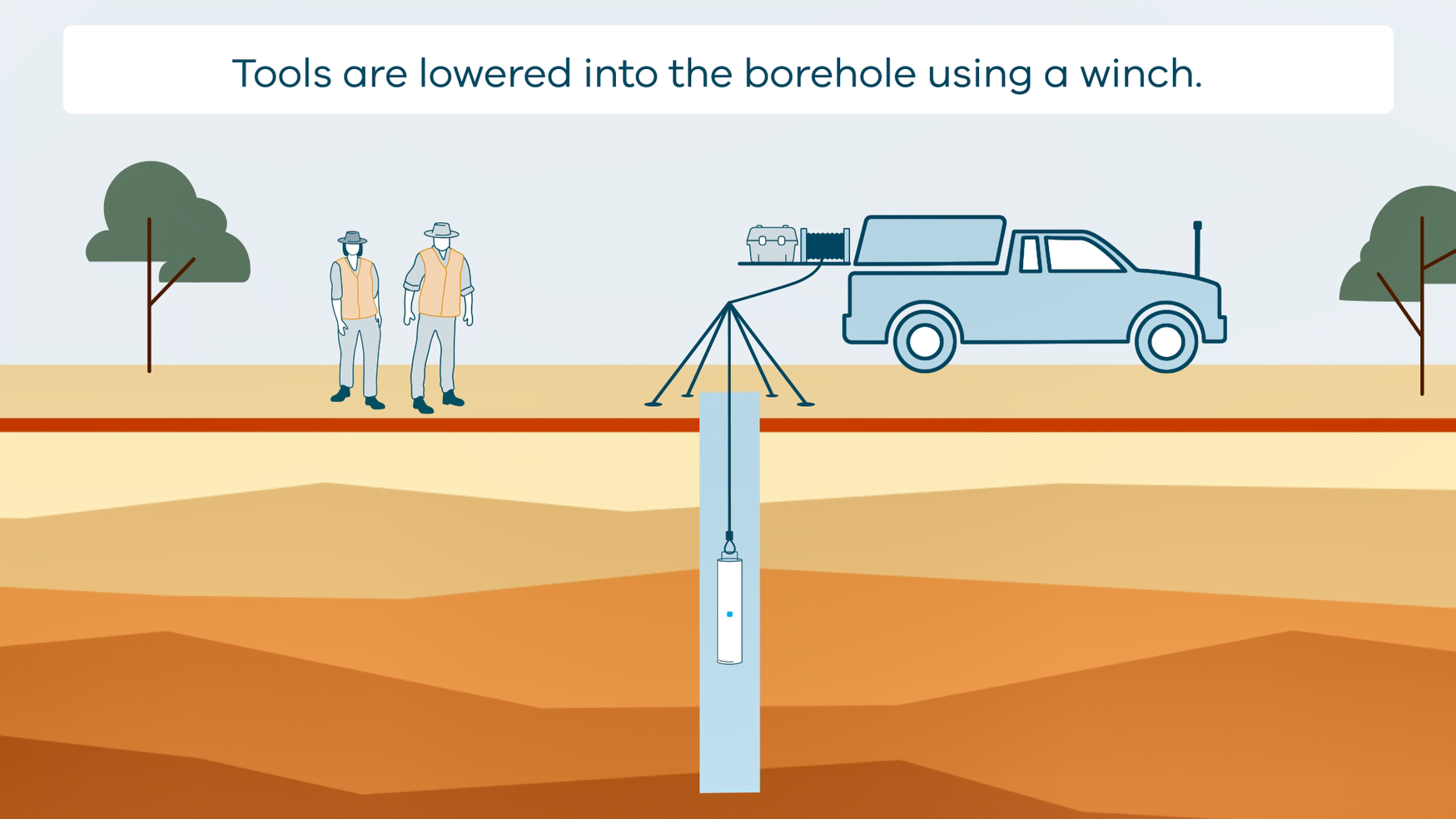
This animation shows how borehole geophysical surveys are conducted. It is part of a series of Field Activity Technique Engagement Animations. The target audience are the communities that are impacted by GA's data acquisition activities. There is no sound or voice over. The 2D animation includes a simplified view of what borehole geophysics equipment looks like, what the equipment measures and how scientists use the data.
-
Geoscience Australia and its predecessors have analysed the hydrochemistry of water sampled from bores, surface features, rainwater and core samples (pore water). Samples have been collected during drilling or monitoring projects, including Exploring for the Future (EFTF). The hydrochemistry database includes physical-chemical parameters (EC, pH, redox potential, dissolved oxygen), major and minor ions, trace elements, isotopes and nutrients. The resource is accessible via the Geoscience Australia Portal <a href="https://portal.ga.gov.au/">(https://portal.ga.gov.au/)</a>
-
This technical report details the methods and results the drilling programs of the Upper Burdekin Groundwater Project conducted as part of Exploring for the Future (EFTF)—an eight year, $225 million Australian Government funded geoscience data and information acquisition program focused on better understanding the potential mineral, energy and groundwater resources across Australia. This report was written by Queensland Government collaborators in the Department of Environment and Science, and is published here as supplied to Geoscience Australia at the conclusion of the project. The drilling program itself was conducted by the Department of Environment and Science as part of the Upper Burdekin Groundwater Project. A total of 17 holes were drilled in 2017-18 at 13 sites with a total combined depth of 943.2 metres. These comprise selected locations across both the Nulla Basalt Province and McBride Basalt Province. A network of 15 monitoring bores were constructed with two test holes backfilled and decommissioned.
-
The Western Davenport region has been identified as an area of interest for future agricultural development. However, realisation of this potential depends on access to a reliable supply of groundwater, underpinned by rigorous geological and groundwater information. A three-dimensional stratigraphic model has been created for the Western Davenport area of the Southern Stuart Corridor project under the Exploring for the Future program. Our interpretation integrates airborne electromagnetic data with historical drillhole and outcrop data to improve geological and hydrogeological understanding. Results show that stratigraphies of the Wiso and Georgina basins are equivalent and laterally continuous in this area. This enables a more complete hydrostratigraphy to be defined and underpins improved hydrogeological conceptualisation. New hydrochemical data support the conceptual model that the aquifers of the Wiso and Georgina basins are interconnected at a regional scale. The initial assessment of water quality indicates that groundwater may support further agricultural development. Analysis of new water chemistry data has improved understanding of groundwater processes and potential areas of recharge. This work will inform management decisions to enhance the economic and social opportunities in the Western Davenport area, while protecting the environmental and cultural value of water resources. <b>Citation:</b> Northey, J.E., Clark, A.D., Smith, M.L. and Hostetler, S., 2020. Delineation of geology and groundwater resources in a frontier region: Western Davenport, Northern Territory. In: Czarnota, K., Roach, I., Abbott, S., Haynes, M., Kositcin, N., Ray, A. and Slatter, E. (eds.) Exploring for the Future: Extended Abstracts, Geoscience Australia, Canberra, 1–4.
-
The Exploring for the Future Project Areas web service depicts the spatial extents of project work undertaken as part of Geoscience Australia's $100.5 million initiative dedicated to boosting investment in resource exploration in Australia. Each project area extent has been generated by aggregating all project work sites into an envelope polygon. An indicative spend on each f the projects is also given.
-
We present a multifaceted hydrogeological investigation of the McBride and Nulla basalt provinces in the Upper Burdekin region, north Queensland. The project aims to better understand their key groundwater system processes to inform future development and water management decisions. This work, carried out as part of the Exploring for the Future Upper Burdekin Groundwater Project, has shown that basalt aquifers in each province are typically unconfined where monitored. Groundwater recharge is widespread but highly variable, largely occurring within the boundaries of the basalt provinces. Groundwater salinity based on electrical conductivity is <1000 μS/cm in the McBride Basalt Province (MBP) and up to 2000 μS/cm in the Nulla Basalt Province (NBP). Groundwater levels have been declining since 2011 (following major flooding in Queensland), showing that the study period covers a small fraction of a longer-functioning dynamic groundwater system. The basalt provinces contain distinct lava flows, and the degree of hydraulic connectivity between them is unclear. Despite similarities in their rock properties, the geometry of lava emplacement leads to different groundwater flow regimes within the two basalt provinces. Radial flow away from the central high elevations towards the edges is characteristic of the MBP, while regional flow from west to east dominates the NBP. Basalt aquifers in both provinces support a range of groundwater-dependent ecosystems, such as springs, some of which sustain flow in tributaries of the Burdekin River. Where streams intersect basalt aquifers, this also results in direct groundwater discharge. Springs and perennial tributaries, particularly emanating from the MBP, provide important inflows to the Burdekin River, especially in the dry season. This work has highlighted that management of MBP and NBP groundwater sources is crucial for maintaining a range of environmental assets in the region and for ensuring access for existing and future users. <b>Citation:</b> Ransley, T.R., Dixon-Jain, P., Cook, S.B., Lai, E.C.S., Kilgour, P., Wallace, L., Dunn, B., Hansen, J.W.L. and Herbert, G., 2020. Hydrogeology of the McBride and Nulla basalt provinces in the Upper Burdekin region, north Queensland. In: Czarnota, K., Roach, I., Abbott, S., Haynes, M., Kositcin, N., Ray, A. and Slatter, E. (eds.) Exploring for the Future: Extended Abstracts, Geoscience Australia, Canberra, 1–4.
-
The Exploring for the Future Southern Stuart Corridor Groundwater Project undertook extensive multidisciplinary geoscientific investigations across four study areas and six Indigenous communities in central Australia to better understand and characterise groundwater resources. The project was developed to support improvements in water resilience for communities and future agricultural developments in the region. Geoscience Australia collected 9800 line kilometres of airborne electromagnetic data, drilled and installed 15 new monitoring bores, acquired 78 surface nuclear magnetic resonance soundings, recorded downhole geophysical data and groundwater level measurements from >50 bores, and completed hydrochemical analysis of 75 samples. Integration of these datasets provided insights into recharge areas and rates, and potential for managed aquifer recharge. The project also improved our understanding of the geological systems hosting groundwater and interconnections between systems. Potential new groundwater supplies, enhanced understanding of groundwater processes and improved geological models will assist water agencies to better manage groundwater resources across the region. <b>Citation:</b> Hostetler, S., Slatter, E., McPherson, A.A., Tan, K.P., McInnes, D. J., Wischusen, J.D.H. and Ellis, J.H., 2020. A multidisciplinary geoscientific approach to support water resilience in communities in Central Australia. In: Czarnota, K., Roach, I., Abbott, S., Haynes, M., Kositcin, N., Ray, A. and Slatter, E. (eds.) Exploring for the Future: Extended Abstracts, Geoscience Australia, Canberra, 1–4.