Earthquake
Type of resources
Keywords
Publication year
Service types
Topics
-
The Philippine archipalego is tectonically complex and seismically hazardous, yet few seismic hazard assessments have provided national coverage. This paper presents an updated probabilistic seismic hazard analysis for the nation. Active shallow crustal seismicity is modeled by faults and gridded point sources accounting for spatially variable occurrence rates. Subduction interfaces are modelled with faults of complex geometry. Intraslab seismicity is modeled by ruptures filling the slab volume. Source geometries and earthquake rates are derived from seismicity catalogs, geophysical datasets, and historic-to-paleoseismic constraints on fault slip rates. The ground motion characterization includes models designed for global use, with partial constraint by residual analysis. Shallow crustal faulting near metropolitan Manila, Davao, and Cebu dominates shaking hazard. In a few places, peak ground acceleration with 10% probability of exceedance in 50 years on rock reaches 1.0 g. The results of this study may assist in calculating the design base shear in the National Structural Code of the Philippines.
-
Scanned enquires and insurance claims requesting information about South Australian Earthquake or Seismic data for teleseismic events. 1959-1987
-
Scanned felt reports from 1902, 1954-2010. One pdf per event.
-
This short video introduces liquefaction and its impact on buildings and other structures. Liquefaction is demonstrated using sand in a glass container and explains why it happens. The video contains images and short clips of liquefaction and introduces some ways engineers lessen the impact of earthquakes on buildings. The second half of the video includes instructions on how to make your own liquefaction demonstration and extend it into an inquiry activity.
-
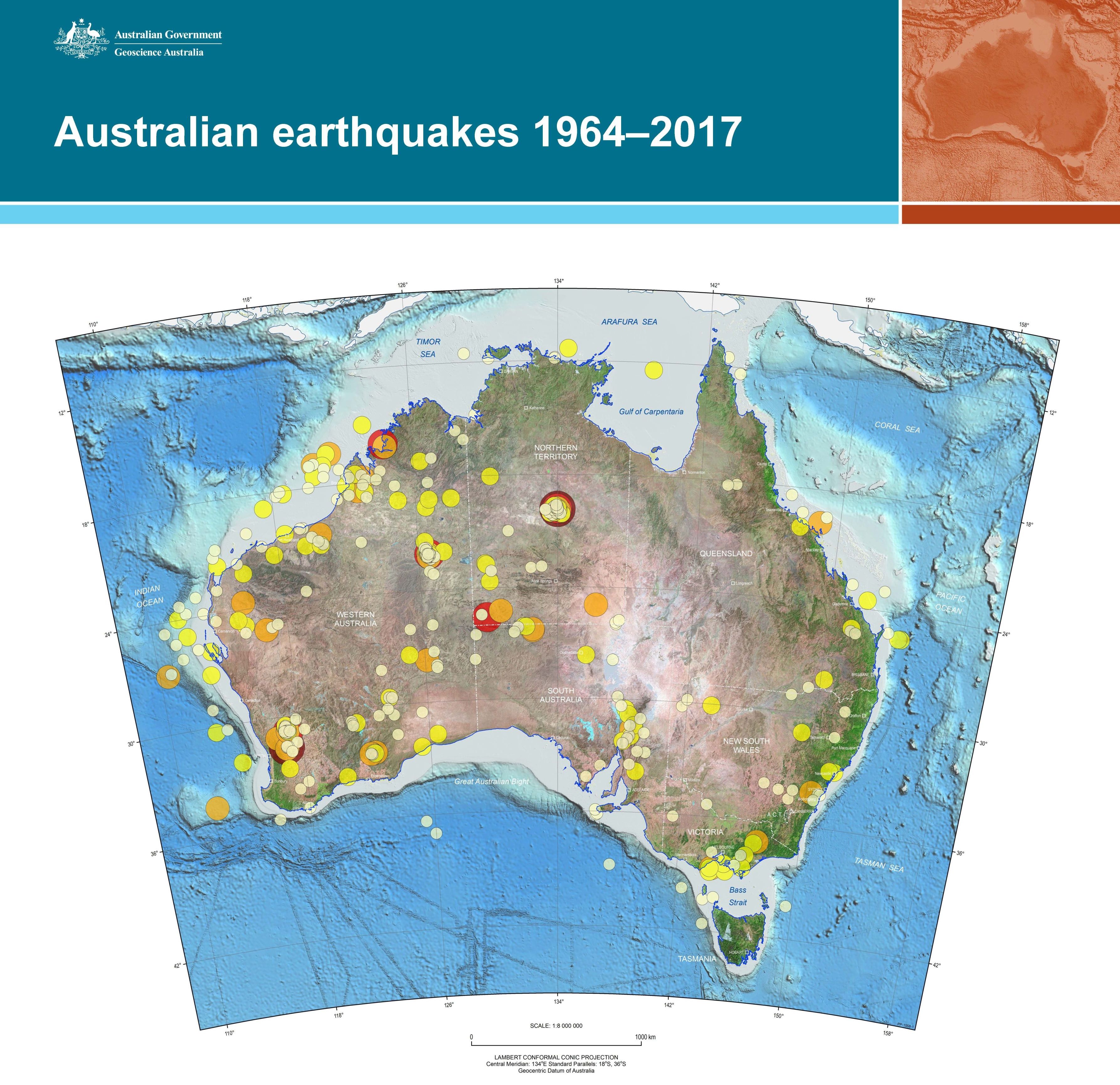
Poster that shows Australian earthquakes greater than a magnitude 4.5 between 1964 and 2017
-
Geoscience Australia and the NSW Department of Industry undertook seismic monitoring of the NSW CSG extraction area in Camden as well as baseline monitoring in the region between 2015 and 2019. Geoscience Australia established and maintained seismic stations to identify of events of greater than ML2.0 within the CSG fields. Three new seismic stations were located near Camden CSG area with two baseline stations in North-West Sydney. This poster details the station builds and seismic monitoring of both the Camden CSG production area and the wider region during the project.
-
The 2018 National Seismic Hazard Assessment of Australia incorporated 19 alternative seismic-source models. The diversity of these models demonstrates the deep epistemic uncertainty that exists with regards to how best to characterize intraplate seismicity. A complex logic tree was developed to incorporate the alternative models into a single hazard model. Similarly, a diverse range of ground-motion models were proposed for use and incorporated using a logic tree. Expert opinion was drawn upon to weight the alternative logic tree branches through a structured expert elicitation process. This process aims to transparently and reproducibly characterize the community distribution of expert estimates for unknown parameters and thereby quantify the epistemic uncertainty around estimates of seismic hazard in Australia. We achieve a multi-model rational consensus where each model, and each expert, is, in accordance with the Australian cultural myth of egalitarianism, given a ‘fair go’. Yet despite this process, we find that the results are not universally accepted. A key issue is a contested boundary between what is scientifically reducible and what remains epistemologically uncertain, with a particular focus on the earthquake catalog. Furthermore, a reduction, on average, of 72% for the 10% in 50 years probability of exceedance peak ground acceleration levels compared with those underpinning existing building design standards, challenges the choice of metrics upon which design codes are based. As questions of epistemic uncertainty are quantified or resolved, changes in our understanding of how the hazard behaves should inform dialogue between scientists, engineers and policy makers, and a re-appraisal of the metrics used to inform risk management decisions of societal importance.
-
You may not realise it but, on average, Australia is rattled every few days by an earthquake of magnitude 3 or above. We don’t feel every small tremor that happens, but the larger earthquakes are powerful enough to cause serious damage to buildings and infrastructure, putting our community’s safety at risk.
-
Set of old historical documents including, Adelaide Observatory Seismological Bulletins, historical events, Stations installations, SA Activity Bulletins, Regional Events, Maintence Reports, Seismometer Handbooks and Rainfall Observations.
-
Detailed Earthquake Location files 2013-2016. Station Journals (Calibrations, logs and site visits) 1991-1993. "Scan Sheets" 1993-2016. Phase Worksheets, 1963-2016.