ENGINEERING
Type of resources
Keywords
Publication year
Topics
-
<p>Critical infrastructure systems provide essential services central to the functioning of Australian communities and the economy. Research into historic catastrophic failures of infrastructure suggests two factors have the strongest influence on such failures: system complexity and tight coupling within such systems. While complexity of these lifeline systems is recognised, the latter factor is often not well-understood, especially in the context of severe natural hazards. <p>Proposed in this paper is a methodology to study the performance of lifeline infrastructure under hazard impact, where key component parameters of complex lifeline systems, along with component interactions, are integrated within an executable model. This model can then be subjected to any number of virtual hazards to assist in identification of non-obvious failure mechanisms, quantify post-hazard system performance, and conduct experimentation with alternate mitigation measures. <p>This process allows for investigating the combined effect of various parameters including component fragilities, system topology, restoration times and costs with their uncertainties, redundancies, and the expected hazard. Much of this information is commercially sensitive or only accessible to specialist groups. Ensuring access to, and effective combination of, such information requires a trusted information-sharing collaboration framework between cross-sectoral experts. This collaboration requires participation from infrastructure operators, researchers, engineers, and government entities. This paper outlines a methodology and tools that have been utilised within such a collaborative project, and documents key learnings from the effort, along with observations on improvement strategies.
-
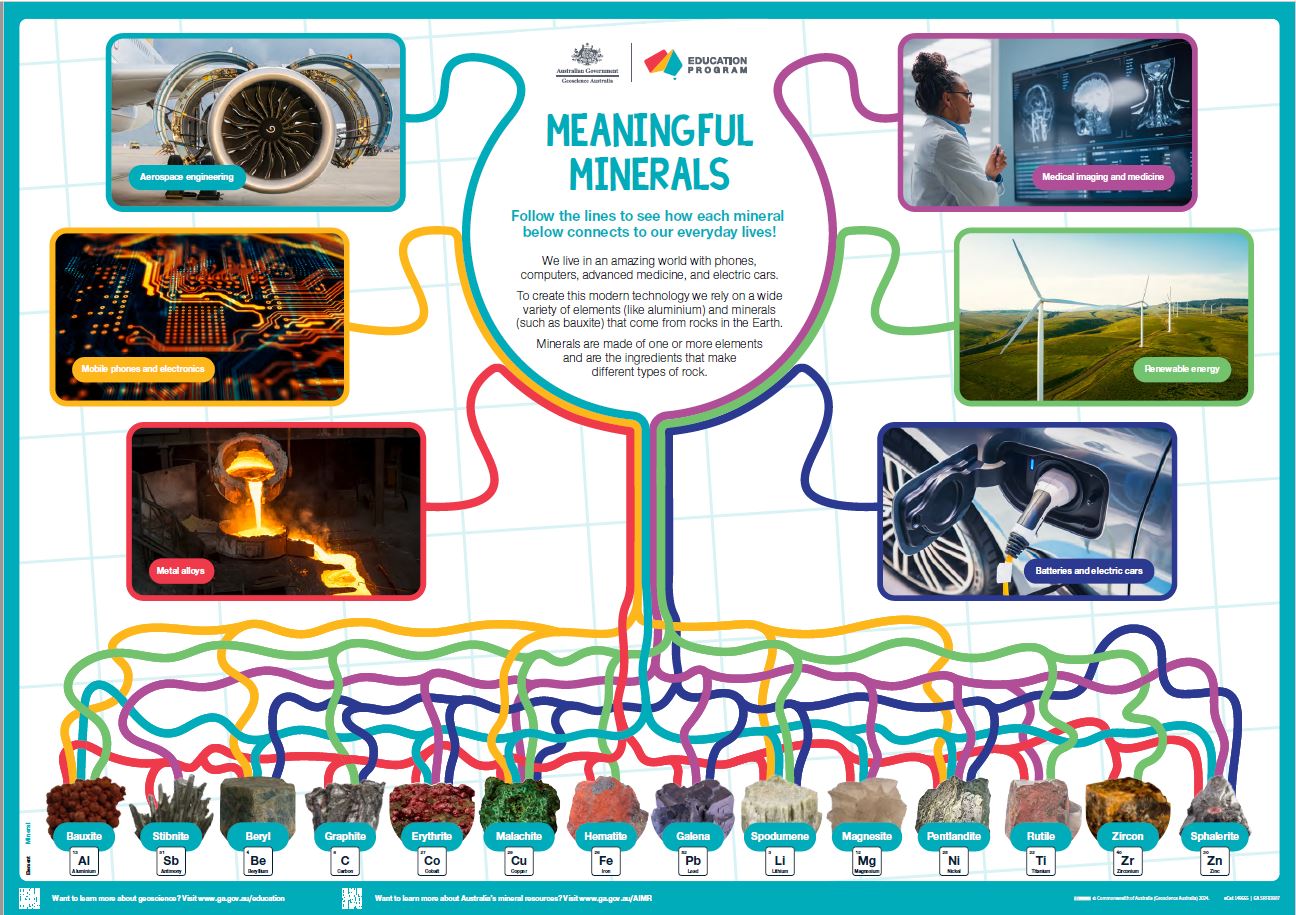
<div>This A1 poster aims to introduce Year 3/4 and older students to the many ways that minerals and elements are used in our everyday lives. </div><div> 6 key uses of 14 critical and strategic minerals are highlighted by colourful lines linking images. Students should take their time viewing the poster; they can follow the wiggly lines from minerals to product or vice versa and work out how many minerals link to each type of use.</div><div> The poster is also suitable for secondary students with the inclusion of a specific element name with each highlighted mineral plus the element symbol and atomic number.</div><div> The poster is intended to be a colourful rich stimulus to engage student interest in the resources from the ground used in our modern world.</div><div><br></div>
-
<div>Global steel demand is forecast to grow in the coming decades with continued development across Asia and Africa. Over the same period, the International Energy Agency suggests that the carbon intensity of steel production will need to decrease rapidly to align with projected pathways to net zero emissions by 2050. Balancing these competing priorities is a challenge that could shift global steelmaking business models. With abundant resources of both iron ore and metallurgical coal, Australia has benefited significantly from traditional steelmaking value chains. In the face of potential disruption, how should Australia navigate the challenges and opportunities accompanying the transition to ’green’ steel? How can geoscience help to identify and leverage Australia’s specific advantages? </div><div><br></div><div>The Green Steel Economic Fairways Mapper is a free, online tool that models the costs of hydrogen-based green ironmaking and steelmaking and maps how these costs vary across Australia. Developed through collaboration between Geoscience Australia and Monash University, it represents a novel approach to model multiple interconnected resource facilities. Following the Economic Fairways approach, the Mapper combines large-scale infrastructure and geoscience datasets to provide a high-level, geospatial analysis of the economic viability of hypothetical green steel projects. In doing so it creates a new capability within Australia—filling the void before the detail and expense of feasibility studies—to understand the broad contours of the decarbonization challenge, and to inform early-stage decision making in the pursuit of low-carbon steel. In this seminar, we introduce the Green Steel Economic Fairways Mapper, demonstrate its capabilities, and discuss some of the insights it reveals. </div>
-
Knowledge of the nature of buildings within CBD areas is fundamental to a broad range of decision making processes, including planning, emergency management and the mitigation of the impact of natural hazards. To support these activities, Geoscience Australia has developed a building information system called the National Exposure Information System (NEXIS) which provides information on buildings across Australia. Most of the building level information in NEXIS is statistically derived, but efforts are being made to include more detailed information on the nature of individual buildings, particularly in CBD areas. This is being achieved in Brisbane through field survey work.
-
Knowledge of the nature of buildings within business precincts is fundamental to a broad range of decision making processes, including planning, emergency management and the mitigation of the impact of natural hazards. To support these activities, Geoscience Australia has developed a building information system called the National Exposure Information System (NEXIS) which provides information on buildings across Australia. Most of the building level information in NEXIS is statistically derived, but efforts are being made to include more detailed information on the nature of individual buildings, particularly in business districts. This is being achieved in North Sydney through field survey work.
-
Knowledge of the nature of buildings within business precincts is fundamental to a broad range of decision making processes, including planning, emergency management and the mitigation of the impact of natural hazards. To support these activities, Geoscience Australia has developed a building information system called the National Exposure Information System (NEXIS) which provides information on buildings across Australia. Most of the building level information in NEXIS is statistically derived, but efforts are being made to include more detailed information on the nature of individual buildings, particularly in business districts. This is being achieved in Adelaide through field survey work.
-
Knowledge of the nature of buildings within business precincts is fundamental to a broad range of decision making processes, including planning, emergency management and the mitigation of the impact of natural hazards. To support these activities, Geoscience Australia has developed a building information system called the National Exposure Information System (NEXIS) which provides information on buildings across Australia. Most of the building level information in NEXIS is statistically derived, but efforts are being made to include more detailed information on the nature of individual buildings, particularly in business districts. This is being achieved in Sydney through field survey work.
-
People, homes, businesses and infrastructure have been severely impacted by the recent flooding in Tweed Shire. Information is needed on the nature of these impacts to assess losses, assess community recovery and contribute to the development of strategies to reduce risk in the future. To collect this information a survey team has been established to gather data on the impact on buildings and businesses. The survey team is being led by Geoscience Australia, the national agency for geoscience research and spatial information, in collaboration with RMIT University and the Tweed Shire Council.
-
Knowledge of the nature of buildings within CBD areas is fundamental to a broad range of decision making processes, including planning, emergency management and the mitigation of the impact of natural hazards. To support these activities, Geoscience Australia has developed a building information system called the National Exposure Information System (NEXIS) which provides information on buildings across Australia. Most of the building level information in NEXIS is statistically derived, but efforts are being made to include more detailed information on the nature of individual buildings, particularly in CBD areas. This is being achieved in Melbourne through field survey work.
-
Knowledge of the nature of buildings within business precincts is fundamental to a broad range of decision making processes, including planning, emergency management and the mitigation of the impact of natural hazards. To support these activities, Geoscience Australia has developed a building information system called the National Exposure Information System (NEXIS) which provides information on buildings across Australia. Most of the building level information in NEXIS is statistically derived, but efforts are being made to include more detailed information on the nature of individual buildings, particularly in business districts. This is being achieved in Southbank through field survey work.