Darling-Curnamona-Delamerian
Type of resources
Keywords
Publication year
Topics
-
<div>The Darling-Curnamona-Delamerian (DCD) project focused on the covered portion of the Delamerian orogen, situated in the south-eastern mainland states of Australia. The aims of the project were to develop a greater understanding of the geodynamic history of the Delamerian Orogen, characterise known magmatic-hydrothermal mineral systems, and assess mineral potential for a suite of minerals including copper (Cu), gold (Au), and nickel (Ni), and critical minerals like platinum-group elements (PGEs) and rare-earth elements (REEs). </div><div>Here, we collate whole rock geochemistry data from new and legacy samples of mafic to intermediate magmatic rocks of the Loch Lilly-Kars Belt in order to determine the likely source of these magmas and constrain the prevailing tectonic setting during their emplacement. We apply multi-elemental diagrams and various elemental discrimination diagrams to characterise various groups of magmatic rocks in these belts, taking into account their geographic affinity and new geochronological data (e.g. Mole et al., 2023; Mole et al., 2024). The geochemical characteristics of these groups and the implications for the tectonic setting into which they were emplaced are discussed. Comparisons are made with potentially similar magmatic rocks of the Koonenberry Belt and Grampians-Stavely Zone. Results from this study have significant implications for the tectonic setting in which the Loch Lilly-Kars Belt developed, and hence also the mineral potential of the Belt. </div><div> </div>
-
Geoscience Australia’s Exploring for the Future program provides precompetitive information to inform decision-making by government, community and industry on the sustainable development of Australia's mineral, energy and groundwater resources. By gathering, analysing and interpreting new and existing precompetitive geoscience data and knowledge, we are building a national picture of Australia’s geology and resource potential. This leads to a strong economy, resilient society and sustainable environment for the benefit of all Australians. This includes supporting Australia’s transition to a low emissions economy, strong resources and agriculture sectors, and economic opportunities and social benefits for Australia’s regional and remote communities. The Exploring for the Future program, which commenced in 2016, is an eight-year, $225m investment by the Australian Government. The Darling-Curnamona-Delamerian (DCD) 2D reflection seismic survey was acquired during May to August 2022 in the Delamerian Orogen, the Murray-Darling basin, the Curnamona Province, and the upper Darling River floodplain regions in South Australia, Victoria and New South Wales. This project is a collaboration between Geoscience Australia (GA), the Geological Survey of South Australia (GSSA), the Geological Survey of Victoria (GSV) and the Geological Survey of New South Wales (GSNSW) and was funded by the Australian Government’s Exploring for the Future (EFTF) program. The overall objective of the EFTF Darling-Curnamona-Delamerian project is to improve the understanding of mineral and groundwater resources of the Curnamona Province and Delamerian Orogen and overlying basin systems through acquisition and interpretation of new pre-competitive geoscience data sets. The total length of acquisition was 1256 km distributed over five deep crustal 2D reflection seismic lines 22GA-DL1 (446 km), 22GA-DL2 (249 km), 22GA-CD1 (287 km), 22GA-CD2 (178 km), 22GA-CD3 (39.5 km) to image deep crustal structures, and a high-resolution 2D reflection seismic line 22GA-UDF (56 km) to explore groundwater resources. The DL lines provide coverage of fundamental geophysical data over the Flinders Range, the Delamerian Province and the Murray-Darling basin region in eastern South Australia and Victoria. The CD lines extend through the Curnamona Province and into the Darling Basin. The UDF line will assist with refining the hydrogeological model, understanding groundwater dynamics, and locating areas better suited to groundwater bores for better quality groundwater in the upper Darling River floodplain area. The data processing was performed by a contractor under the supervision of Geoscience Australia. The five deep crustal lines (22GA-DL1,DL2,CD1,CD2,CD3) were processed with record lengths of 20 and 8 seconds, while the shallow high-resolution line (22GA-UDF) was processed at a 4 second length. This processing yielded DMO Stack, Post-Stack Time Migration, and Pre-Stack Time Migration products. <strong>Raw shot gathers and processed gathers for this survey are available on request from clientservices@ga.gov.au - Quote eCat# 147423</strong>
-
The Exploring for the Future program Showcase 2023 was held on 15-17 August 2023. Day 2 - 16th August talks included: Highways to Discovery and Understanding Session AusAEM - Unraveling Australia's Landscape with Airborne Electromagnetics – Dr Yusen Ley Cooper Exploring for the Future Data Discovery Portal: A scenic tour – Simon van der Wielen Towards equitable access to regional geoscience information– Dr Kathryn Waltenberg Community engagement and geoscience knowledge sharing: towards inclusive national data and knowledge provision – Dr Meredith Orr Foundational Geoscience Session The power of national scale geological mapping – Dr Eloise Beyer New surface mineralogical and geochemical maps of Australia – Dr Patrice de Caritat Imaging Australia’s Lithospheric Architecture – Dr Babak Hejrani Metallogenic Potential of the Delamerian Margin– Dr Yanbo Cheng You can access the recording of the talks from YouTube here: <a href="https://youtu.be/ZPp2sv2nuXI">2023 Showcase Day 2 - Part 1</a> <a href="https://youtu.be/dvqP8Z5yVtY">2023 Showcase Day 2 - Part 2</a>
-
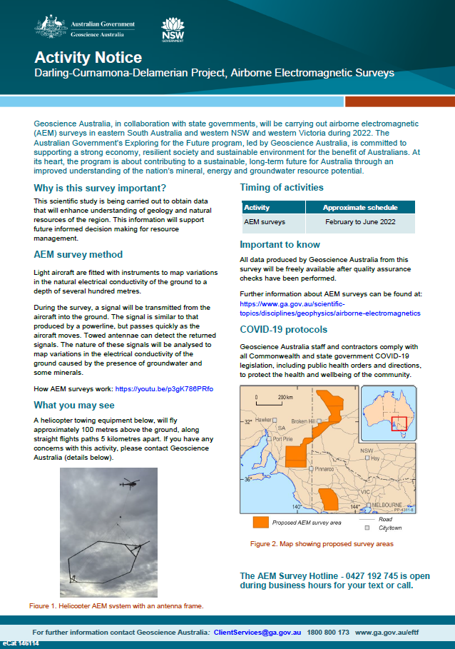
Geoscience Australia, in collaboration with state governments, will be carrying out airborne electromagnetic (AEM) surveys in eastern South Australia and western NSW and Victoria during 2022. The Australian Government’s Exploring for the Future program, led by Geoscience Australia, is committed to supporting a strong economy, resilient society and sustainable environment for the benefit of Australians. At its heart, the program is about contributing to a sustainable, long-term future for Australia through an improved understanding of the nation’s mineral, energy and groundwater resource potential <p>
-
<div><strong>Output type: </strong>Exploring for the Future Extended Abstract </div><div><br></div><div><strong>Short Abstract: </strong>The Delamerian Orogen, with a length of ~1000 km on mainland Australia and a proven potential to host mineralisation, represents an evolving exploration opportunity. However, uncertainty surrounding the age and tectonic setting of the orogen is a barrier to confident exploration in frontier covered regions, such as the Loch Lilly-Kars Belt in western New South Wales and South Australia. A major area of uncertainty is the configuration and extent of the Cambrian convergent-margin system and lateral variations thereof. In this study, we highlight multidisciplinary data from new and legacy sources, including lithology, geochronology, geochemistry, potential-field geophysics, deep-crustal seismic, and magnetotelluric data that permit a revised interpretation of the geological framework for the Delamerian Orogen in mainland Australia, with an emphasis on the covered, central part of the system. These data indicate that a largely continuous, east-facing volcanic arc developed in the Delamerian Orogen in the Cambrian. The arc transitions from exhibiting a strong continental affinity in the Koonenberry Belt to having less continental affinity in the Grampians-Stavely Zone of Victoria. The Loch Lilly-Kars Belt is interpreted to have occupied a volcanic arc to incipient back-arc position in the middle Cambrian. </div><div><br></div><div><strong>Citation: </strong>Clark A.D., et al., 2024. Cambrian convergent margin configuration in the Delamerian Orogen of mainland Australia. In: Czarnota, K. (ed.) Exploring for the Future: Extended Abstracts, Geoscience Australia, Canberra, https://doi.org/10.26186/149647 </div>
-
<div><strong>Output type: </strong>Exploring for the Future Extended Abstract</div><div><br></div><div><strong>Short abstract: </strong> Crustal architecture provides first order controls on the distribution of mineral resources of an area and is best imaged by deep seismic reflection data. Here we present a first interpretation of seismic line 22GA-CD2, acquired as part of the Darling-Curnamona-Delamerian (DCD) project. Line 22GA-CD2 images the central eastern Delamerian Orogen, where basement rocks are concealed by the Murray Basin. Key findings include: (i) the crustal architecture preserves many characteristics of the early evolution of west-dipping Delamerian subduction, accretion and orogeny between ~ 515 Ma - 495 Ma. This initial configuration has been reworked and reactivated during younger orogenic events; (ii) the lower and middle crust constitutes the newly defined Barrier Seismic Province, which is also imaged in legacy seismic reflection line 05GA-TL1 and interpreted to continue northeast to the Olepoloko Fault; (iii) a similar seismic character to that of the Barrier Seismic Province has been observed in legacy seismic reflection lines in Victoria and related to a Cambrian accretionary setting and adjacent foreland; (iv) the present-day upper crustal configuration is largely the result of contractional fault reactivation, with significant vertical movements during the Kanimblan-Alice Springs Orogeny (~ 360 Ma - 340 Ma); (v) a large area of prospective rocks for mineral deposits with Cambrian arc-affiliation are accessible to exploration under shallow cover of the Murray Basin (often less than 200 m).</div><div> </div><div><strong>Citation: </strong>Doublier M.P., et al., 2024. Crustal architecture along seismic line 22GA-CD2: new insights from the Darling-Curnamona-Delamerian deep seismic reflection survey. In: Czarnota, K. (ed.) Exploring for the Future: Extended Abstracts, Geoscience Australia, Canberra, https://dx.doi.org/10.26186/149658</div>
-
<div><strong>Output Type: </strong>Exploring for the Future Extended Abstract</div><div><br></div><div><strong>Short Abstract: </strong>We have used new magnetotelluric data collected in the Curnamona Province and Delamerian Orogen to image electrical resistivity structures. Our resistivity model confirms crustal-scale conductive features mapped by AusLAMP models, i.e., the prominent Curnamona Province Conductor and the two Nackara Arc conductors, and resolves them in greater detail. The new model also reveals several apparently continuous arcuate conductors within the lower crust extending from the Eastern Nackara Arc Conductor to Broken Hill, and further into the Delamerian Orogen. In the west, these conductors coincide with the dominant structural grain of the Delamerian Orogen and are interpreted to represent ancient fluid pathways associated with major faults in the area. The eastern conductor diverts from the dominant structural grain in the Grasmere knee zone. The source of this conductor is enigmatic, although possibilities could include complex deformation as the Cambrian convergent margin was deformed in the Delamerian Orogeny, or younger events such as the emplacement of the late-Silurian Allambie Woolshed Granite. The conductive features provide new insights for understanding the geodynamic events and potential mineral systems associated with the transition from Proterozoic Australia in the west to the mostly Phanerozoic Tasmanides in the east. These conductivity anomalies may represent large-scale trans-crustal structures, which can place fundamental control on the spatial distribution and formation of mineral systems in the Curnamona Province and Delamerian Orogen.</div><div><br></div><div><strong>Citation: </strong>Jiang, W., Clark, A., Cheng, Y., Doublier, M., Hitchman, A. & Duan, J., 2024. Unveiling electrical resistivity structures along the undercover Delamerian Orogen, Southeast Australia. In: Czarnota, K. (ed.) Exploring for the Future: Extended Abstracts, Geoscience Australia, Canberra, https://doi.org/10.26186/149232</div>
-
<div>Geoscience Australia’s Exploring for the Future program provides precompetitive information to inform decision-making by government, community and industry on the sustainable development of Australia's mineral, energy and groundwater resources. By gathering, analysing and interpreting new and existing precompetitive geoscience data and knowledge, we are building a national picture of Australia’s geology and resource potential. This leads to a strong economy, resilient society and sustainable environment for the benefit of all Australians. This includes supporting Australia’s transition to net zero emissions, strong, sustainable resources and agriculture sectors, and economic opportunities and social benefits for Australia’s regional and remote communities. The Exploring for the Future program, which commenced in 2016, is an eight year, $225m investment by the Australian Government.</div><div><br></div><div>We present a 3-D resistivity model derived from magnetotelluric data collected by two recent surveys in the Curnamona and Delamerian Region: the Curnamona Cube survey led by the University of Adelaide and funded by AuScope and the Curnamona Cube Extension survey (https://doi.org/10.26186/147904) by Geoscience Australia as part of Exploring for the Future Program. In total, data from 231 sites were used to produce 3-D models using the ModEM code. Details of data inversion are provided in the Readme.pdf file. The resistivity model can be used to enhance the understanding of the geodynamics and mineral potential in the Curnamona Province and Delamerian Orogen.</div><div><br></div><div>We greatly appreciate that Prof. Graham Heinson from the University of Adelaide has made the Curnamona Cube survey data available for this work. The modelling work was undertaken with the assistance of resources from the National Computational Infrastructure (NCI Australia).</div><div><br></div><div>This release package contains the preferred 3-D resistivity model in SGrid format and geo-referenced depth slices in .tif format.</div><div><br></div>
-
Short abstract: The Delamerian Orogen is spatially and temporally extensive, covering five states in central and eastern Australia. The orogen records the transition from Proterozoic Australia to the Phanerozoic Tasmanides, starting with rifting of the Rodinian supercontinent and transition to a passive margin from ca. 830 to 530 Ma, then developing as a convergent eastern Gondwanan margin from ca. 530 Ma that was terminated by the mid-to-late Cambrian Delamerian Orogeny. The orogen was later impacted by younger geodynamic events, particularly in the Ordovician-Silurian-Devonian. Due to the paucity of exposure, in particular in its central segment, and the complex cover sequences, significant parts of the Delamerian Orogen remain poorly documented. The orogen is also underexplored for resources despite demonstrated potential for magmatic-hydrothermal and other mineral systems. As part of the Exploring for the Future program, the Darling-Curnamona-Delamerian project is working to improve geodynamic framework and mineral systems knowledge through a range of activities including; analysis of legacy drill core, new stratigraphic drilling and major geophysical data acquisition campaigns (airborne electromagnetic, deep crustal seismic reflection, magnetotelluric). Significant first results reveal the existence of a corridor of Siluro-Devonian igneous rocks flanked by Cambrian igneous rocks within the Loch Lilly-Kars Belt, possibly related to an episode of rifting or extension, with potential for rift-related and magmatic-hydrothermal mineral systems of that age. <b>Citation:</b> Gilmore P.J., Roach I.C., Doublier M.P., Mole D.R., Cheng Y., Clark A.D. & Pitt L., 2023. From The Delamerian Orogen: exposing an undercover arc. In: Czarnota, K. (ed.) Exploring for the Future: Extended Abstracts, Geoscience Australia, Canberra, https://dx.doi.org/10.26186/148679
-
The Exploring for the Future program Showcase 2023 was held on 15-17 August 2023. Day 3 - 17th August talks included: Geological Processes and Resources Session Large scale hydrogen storage: The role of salt caverns in Australia’s transition to net zero – Dr Andrew Feitz Basin-Hosted Base Metal Deposits – Dr Evgeniy Bastrakov Upper Darling Floodplain: Groundwater dependent ecosystem assessment – Dr Sarah Buckerfield Atlas of Australian Mine Waste: Waste not, want not – Jane Thorne Resource Potential Theme National-scale mineral potential assessments: supporting mineral exploration in the transition to net zero – Dr Arianne Ford Australia’s Onshore Basin Inventories: Energy – Tehani Palu Prioritising regional groundwater assessments using the national hydrogeological inventory – Dr Steven Lewis Assessing the energy resources potential in underexplored regions – Dr Barry Bradshaw You can access the recording of the talks from YouTube here: <a href="https://youtu.be/pc0a7ArOtN4">2023 Showcase Day 3 - Part 1</a> <a href="https://youtu.be/vpjoVYIjteA">2023 Showcase Day 3 - Part 2</a>