Darling-Curnamona-Delamerian
Type of resources
Keywords
Publication year
Topics
-
Geoscience Australia’s Exploring for the Future program provides precompetitive information to inform decision-making by government, community and industry on the sustainable development of Australia's mineral, energy and groundwater resources. By gathering, analysing and interpreting new and existing precompetitive geoscience data and knowledge, we are building a national picture of Australia’s geology and resource potential. This leads to a strong economy, resilient society and sustainable environment for the benefit of all Australians. This includes supporting Australia’s transition to a low emissions economy, strong resources and agriculture sectors, and economic opportunities and social benefits for Australia’s regional and remote communities. The Exploring for the Future program, which commenced in 2016, is an eight-year, $225m investment by the Australian Government. The Darling-Curnamona-Delamerian (DCD) 2D reflection seismic survey was acquired during May to August 2022 in the Delamerian Orogen, the Murray-Darling basin, the Curnamona Province, and the upper Darling River floodplain regions in South Australia, Victoria and New South Wales. This project is a collaboration between Geoscience Australia (GA), the Geological Survey of South Australia (GSSA), the Geological Survey of Victoria (GSV) and the Geological Survey of New South Wales (GSNSW) and was funded by the Australian Government’s Exploring for the Future (EFTF) program. The overall objective of the EFTF Darling-Curnamona-Delamerian project is to improve the understanding of mineral and groundwater resources of the Curnamona Province and Delamerian Orogen and overlying basin systems through acquisition and interpretation of new pre-competitive geoscience data sets. The total length of acquisition was 1256 km distributed over five deep crustal 2D reflection seismic lines 22GA-DL1 (446 km), 22GA-DL2 (249 km), 22GA-CD1 (287 km), 22GA-CD2 (178 km), 22GA-CD3 (39.5 km) to image deep crustal structures, and a high-resolution 2D reflection seismic line 22GA-UDF (56 km) to explore groundwater resources. The DL lines provide coverage of fundamental geophysical data over the Flinders Range, the Delamerian Province and the Murray-Darling basin region in eastern South Australia and Victoria. The CD lines extend through the Curnamona Province and into the Darling Basin. The UDF line will assist with refining the hydrogeological model, understanding groundwater dynamics, and locating areas better suited to groundwater bores for better quality groundwater in the upper Darling River floodplain area. The data processing was performed by a contractor under the supervision of Geoscience Australia. The five deep crustal lines (22GA-DL1,DL2,CD1,CD2,CD3) were processed with record lengths of 20 and 8 seconds, while the shallow high-resolution line (22GA-UDF) was processed at a 4 second length. This processing yielded DMO Stack, Post-Stack Time Migration, and Pre-Stack Time Migration products. <strong>Raw shot gathers and processed gathers for this survey are available on request from clientservices@ga.gov.au - Quote eCat# 147423</strong>
-
The Exploring for the Future program Showcase 2023 was held on 15-17 August 2023. Day 2 - 16th August talks included: Highways to Discovery and Understanding Session AusAEM - Unraveling Australia's Landscape with Airborne Electromagnetics – Dr Yusen Ley Cooper Exploring for the Future Data Discovery Portal: A scenic tour – Simon van der Wielen Towards equitable access to regional geoscience information– Dr Kathryn Waltenberg Community engagement and geoscience knowledge sharing: towards inclusive national data and knowledge provision – Dr Meredith Orr Foundational Geoscience Session The power of national scale geological mapping – Dr Eloise Beyer New surface mineralogical and geochemical maps of Australia – Dr Patrice de Caritat Imaging Australia’s Lithospheric Architecture – Dr Babak Hejrani Metallogenic Potential of the Delamerian Margin– Dr Yanbo Cheng You can access the recording of the talks from YouTube here: <a href="https://youtu.be/ZPp2sv2nuXI">2023 Showcase Day 2 - Part 1</a> <a href="https://youtu.be/dvqP8Z5yVtY">2023 Showcase Day 2 - Part 2</a>
-
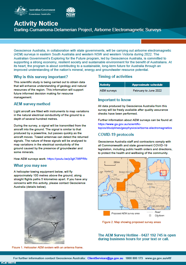
Geoscience Australia, in collaboration with state governments, will be carrying out airborne electromagnetic (AEM) surveys in eastern South Australia and western NSW and Victoria during 2022. The Australian Government’s Exploring for the Future program, led by Geoscience Australia, is committed to supporting a strong economy, resilient society and sustainable environment for the benefit of Australians. At its heart, the program is about contributing to a sustainable, long-term future for Australia through an improved understanding of the nation’s mineral, energy and groundwater resource potential <p>
-
<div><strong>Output type: </strong>Exploring for the Future Extended Abstract </div><div><br></div><div><strong>Short Abstract: </strong>The Delamerian Orogen, with a length of ~1000 km on mainland Australia and a proven potential to host mineralisation, represents an evolving exploration opportunity. However, uncertainty surrounding the age and tectonic setting of the orogen is a barrier to confident exploration in frontier covered regions, such as the Loch Lilly-Kars Belt in western New South Wales and South Australia. A major area of uncertainty is the configuration and extent of the Cambrian convergent-margin system and lateral variations thereof. In this study, we highlight multidisciplinary data from new and legacy sources, including lithology, geochronology, geochemistry, potential-field geophysics, deep-crustal seismic, and magnetotelluric data that permit a revised interpretation of the geological framework for the Delamerian Orogen in mainland Australia, with an emphasis on the covered, central part of the system. These data indicate that a largely continuous, east-facing volcanic arc developed in the Delamerian Orogen in the Cambrian. The arc transitions from exhibiting a strong continental affinity in the Koonenberry Belt to having less continental affinity in the Grampians-Stavely Zone of Victoria. The Loch Lilly-Kars Belt is interpreted to have occupied a volcanic arc to incipient back-arc position in the middle Cambrian. </div><div><br></div><div><strong>Citation: </strong>Clark A.D., et al., 2024. Cambrian convergent margin configuration in the Delamerian Orogen of mainland Australia. In: Czarnota, K. (ed.) Exploring for the Future: Extended Abstracts, Geoscience Australia, Canberra, https://doi.org/10.26186/149647 </div>
-
<div>Geoscience Australia’s Exploring for the Future program provides precompetitive information to inform decision-making by government, community and industry on the sustainable development of Australia's mineral, energy and groundwater resources. By gathering, analysing and interpreting new and existing precompetitive geoscience data and knowledge, we are building a national picture of Australia’s geology and resource potential. This leads to a strong economy, resilient society and sustainable environment for the benefit of all Australians. This includes supporting Australia’s transition to net zero emissions, strong, sustainable resources and agriculture sectors, and economic opportunities and social benefits for Australia’s regional and remote communities. The Exploring for the Future program, which commenced in 2016, is an eight year, $225m investment by the Australian Government.</div><div><br></div><div>We present a 3-D resistivity model derived from magnetotelluric data collected by two recent surveys in the Curnamona and Delamerian Region: the Curnamona Cube survey led by the University of Adelaide and funded by AuScope and the Curnamona Cube Extension survey (https://doi.org/10.26186/147904) by Geoscience Australia as part of Exploring for the Future Program. In total, data from 231 sites were used to produce 3-D models using the ModEM code. Details of data inversion are provided in the Readme.pdf file. The resistivity model can be used to enhance the understanding of the geodynamics and mineral potential in the Curnamona Province and Delamerian Orogen.</div><div><br></div><div>We greatly appreciate that Prof. Graham Heinson from the University of Adelaide has made the Curnamona Cube survey data available for this work. The modelling work was undertaken with the assistance of resources from the National Computational Infrastructure (NCI Australia).</div><div><br></div><div>This release package contains the preferred 3-D resistivity model in SGrid format and geo-referenced depth slices in .tif format.</div><div><br></div>
-
The Exploring for the Future program Showcase 2023 was held on 15-17 August 2023. Day 3 - 17th August talks included: Geological Processes and Resources Session Large scale hydrogen storage: The role of salt caverns in Australia’s transition to net zero – Dr Andrew Feitz Basin-Hosted Base Metal Deposits – Dr Evgeniy Bastrakov Upper Darling Floodplain: Groundwater dependent ecosystem assessment – Dr Sarah Buckerfield Atlas of Australian Mine Waste: Waste not, want not – Jane Thorne Resource Potential Theme National-scale mineral potential assessments: supporting mineral exploration in the transition to net zero – Dr Arianne Ford Australia’s Onshore Basin Inventories: Energy – Tehani Palu Prioritising regional groundwater assessments using the national hydrogeological inventory – Dr Steven Lewis Assessing the energy resources potential in underexplored regions – Dr Barry Bradshaw You can access the recording of the talks from YouTube here: <a href="https://youtu.be/pc0a7ArOtN4">2023 Showcase Day 3 - Part 1</a> <a href="https://youtu.be/vpjoVYIjteA">2023 Showcase Day 3 - Part 2</a>
-
<div>Geoscience Australia’s Exploring for the Future program provides precompetitive information to inform decision-making by government, community and industry on the sustainable development of Australia's mineral, energy and groundwater resources. By gathering, analysing and interpreting new and existing precompetitive geoscience data and knowledge, we are building a national picture of Australia’s geology and resource potential. This leads to a strong economy, resilient society and sustainable environment for the benefit of all Australians. This includes supporting Australia’s transition to net zero emissions, strong, sustainable resources and agriculture sectors, and economic opportunities and social benefits for Australia’s regional and remote communities. The Exploring for the Future program, which commenced in 2016, is an eight year, $225m investment by the Australian Government. This work contributes to building a better understanding of the Australian continent, whilst giving the Australian public the tools they need to help them make informed decisions in their areas of interest.</div><div><br></div><div>As part of the Australia's Resources Framework Project, in the Exploring for the Future Program, Geoscience Australia and CSIRO undertook a magnetic source depth study across four areas, with the objectives of generating cover model constraints from magnetic modelling to expand national coverage, and to improve our subsurface understanding of these areas. During this study, 2005 magnetic estimates of depth to the top of magnetization were generated, with solutions derived using a consistent methodology (targeted magnetic inversion modelling, or TMIM; also known as ‘sweet-spot’ modelling). The methodology for these estimates are detailed in a summary report by Foss et al (2024), and is available for download through Geoscience Australia’s enterprise catalogue (https://pid.geoscience.gov.au/dataset/ga/149239). </div><div><br></div><div>The new points were generated over four areas: 1) the western part of Tasmania that is the southernmost extension of the Darling-Curnamona-Delamerian (DCD) project area; 2) northeastern Queensland; 3) the Officer Basin area of western South Australia and southeastern West Australia; and 4) the Eastern Resources Corridor (ERC), covering eastern South Australia, southwest Queensland, western New South Wales and western Victoria. These depth estimates have been released, together with a summary report detailing the data and methodology used to generate the results, through Geoscience Australia's product catalogue (ecat) at https://pid.geoscience.gov.au/dataset/ga/149239.</div><div><br></div><div>This supplementary data release contains the chronostratigraphic attribution of the new TMIM magnetic depth estimates, which range in depth from at surface to 13,294 m below ground. To ensure that the interpretations took into account the local geological features, the magnetic depth estimates were integrated and interpreted with other geological and geophysical datasets, including borehole stratigraphic logs, potential fields images, surface and solid geology maps, and airborne electromagnetic interpretations (where available). </div><div><br></div><div>Each depth-solution is interpretively ascribed to either a chronostratigraphic boundary with the stratigraphic units above and below the depth estimate, or the stratigraphic unit that the depth estimate occurs within, populated from the Australian Stratigraphic Units Database (ASUD). Stratigraphic attribution adds value and informs users of the depth to certain stratigraphic units in their areas of interest. Each solution is accompanied by confidence estimates. The depth estimate points are formatted for compliance with Geoscience Australia’s (GA) Estimates of Geological and Geophysical Surfaces (EGGS) database, the national repository for standardised depth estimate points. </div><div><br></div><div>Results from these interpretations provided some support to stratigraphic drillhole targeting, as part of the Delamerian Margins NSW National Drilling Initiative campaign, a collaboration between GA’s EFTF program, the MinEx CRC National Drilling Initiative and the Geological Survey of New South Wales. The magnetic depth-estimate solutions produced within this study provide important depth constraints in data-poor areas. These data help to construct a better understanding of the 3D geometry of the Australian continent and aid in cover thickness modelling activities. The availability of the depth-estimate solutions via the EGGS database through Geoscience Australia’s Portal creates enduring value to the public.</div>
-
<div>As part of the Delamerian Margins NSW National Drilling Initiative campaign, seventeen stratigraphic boreholes were drilled between Broken Hill and Wentworth, in Western NSW. These holes were designed to test stratigraphic, structural, and mineral systems questions in the New South Wales portion of the Delamerian Margin. Drilling was conducted between March and June 2023 and was undertaken by Geoscience Australia in collaboration with MinEx CRC. This report outlines basic borehole targeting rationale, borehole metadata, and analyses performed immediately following drilling to accompany data available through the Geoscience Australia portal.</div><div><br></div><div>Geoscience Australia’s Exploring for the Future program provides precompetitive information to inform decision-making by government, community and industry on the sustainable development of Australia's mineral, energy and groundwater resources. By gathering, analysing and interpreting new and existing precompetitive geoscience data and knowledge, we are building a national picture of Australia’s geology and resource potential. This leads to a strong economy, resilient society and sustainable environment for the benefit of all Australians. This includes supporting Australia’s transition to net zero emissions, strong, sustainable resources and agriculture sectors, and economic opportunities and social benefits for Australia’s regional and remote communities. The Exploring for the Future program, which commenced in 2016, is an eight year, $225m investment by the Australian Government.</div>
-
<div>This data package contains interpretations of airborne electromagnetic (AEM) conductivity sections in the Exploring for the Future (EFTF) program’s Eastern Resources Corridor (ERC) study area, in south eastern Australia. Conductivity sections from 3 AEM surveys were interpreted to provide a continuous interpretation across the study area – the EFTF AusAEM ERC (Ley-Cooper, 2021), the Frome Embayment TEMPEST (Costelloe et al., 2012) and the MinEx CRC Mundi (Brodie, 2021) AEM surveys. Selected lines from the Frome Embayment TEMPEST and MinEx CRC Mundi surveys were chosen for interpretation to align with the 20 km line-spaced EFTF AusAEM ERC survey (Figure 1).</div><div>The aim of this study was to interpret the AEM conductivity sections to develop a regional understanding of the near-surface stratigraphy and structural architecture. To ensure that the interpretations took into account the local geological features, the AEM conductivity sections were integrated and interpreted with other geological and geophysical datasets, such as boreholes, potential fields, surface and basement geology maps, and seismic interpretations. This approach provides a near-surface fundamental regional geological framework to support more detailed investigations. </div><div>This study interpreted between the ground surface and 500 m depth along almost 30,000 line kilometres of nominally 20 km line-spaced AEM conductivity sections, across an area of approximately 550,000 km2. These interpretations delineate the geo-electrical features that correspond to major chronostratigraphic boundaries, and capture detailed stratigraphic information associated with these boundaries. These interpretations produced approximately 170,000 depth estimate points or approximately 9,100 3D line segments, each attributed with high-quality geometric, stratigraphic, and ancillary data. The depth estimate points are formatted for compliance with Geoscience Australia’s (GA) Estimates of Geological and Geophysical Surfaces (EGGS) database, the national repository for standardised depth estimate points. </div><div>Results from these interpretations provided support to stratigraphic drillhole targeting, as part of the Delamerian Margins NSW National Drilling Initiative campaign, a collaboration between GA’s EFTF program, the MinEx CRC National Drilling Initiative and the Geological Survey of New South Wales. The interpretations have applications in a wide range of disciplines, such as mineral, energy and groundwater resource exploration, environmental management, subsurface mapping, tectonic evolution studies, and cover thickness, prospectivity, and economic modelling. It is anticipated that these interpretations will benefit government, industry and academia with interest in the geology of the ERC region.</div>
-
Communities and ecosystems along the Darling River face critical water shortages and water quality issues including high salinity and algal blooms due to a reliance on declining surface water flows, which are impacted by extraction and drought, exacerbated by increases in temperature driven by climate change. The Darling River, characterised by highly variable flows, is the primary water source for the region and our understanding of the spatial extent and character of lower salinity groundwater within the surrounding Darling Alluvium, which could provide an alternative water source, is limited. Scientific understanding of the highly variable groundwater-surface water system dynamics of the Darling River is also an integral part of the evidence base required to manage the water resources of the wider Murray-Darling Basin, which has experienced critical water shortages for domestic and agricultural consumptive use and serious ecological decline due to reduced flows. Other relevant groundwater systems in the study area include aquifers of the underlying Eromanga and Surat Basins in the north, aquifers of the Murray Basin in the south, and fractured rock aquifers of the Darling Basin in the south-central area. Understanding of connectivity between these systems and the groundwater systems within the Darling Alluvium, and surface water of the Darling River, is also limited. Here we present the findings of a desktop analysis combining previous research with new analysis on water level, hydrochemistry, and Airborne Electromagnetic depth sections. This integration suggests that basement geometry and hydrostratigraphy within the Darling Alluvium are key structural controls on surface-groundwater connectivity, and the occurrence of a saline groundwater system within the lower part of the alluvium which impacts the quality of surface water and shallow alluvial groundwater resources. Further data acquisition and integrated analysis are planned to test these relationships as part of the Upper Darling Floodplain project. <b>Citation:</b> Buckerfield S., McPherson A., Tan K. P., Kilgour P. & Buchanan S., 2022. From Upper Darling Floodplain groundwater resource assessment. In: Czarnota, K. (ed.) Exploring for the Future: Extended Abstracts, Geoscience Australia, Canberra, https://dx.doi.org/10.26186/146847