MAG3D
Type of resources
Keywords
Publication year
Topics
-

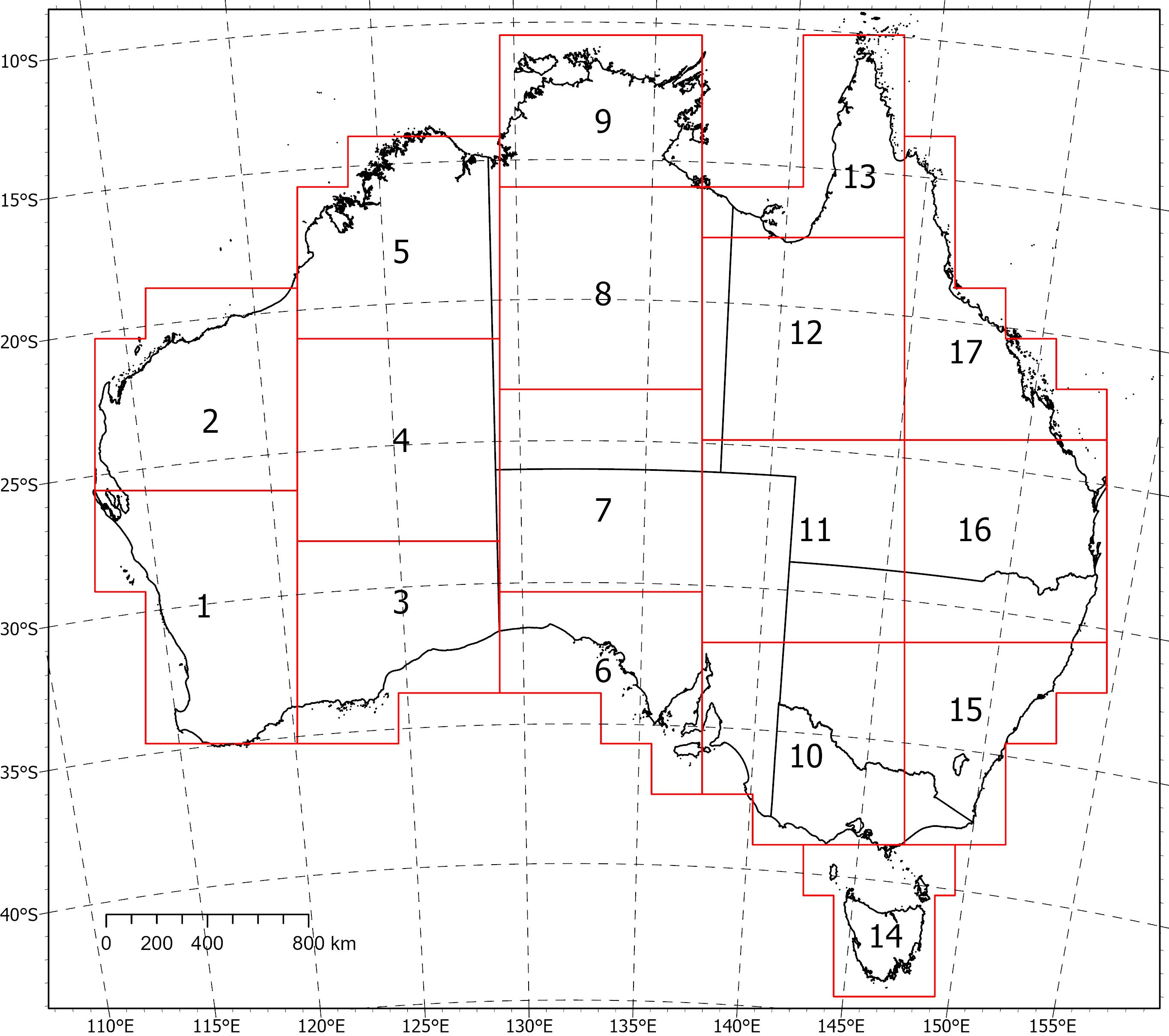
<div>Two coincident, crustal-scale models, one of magnetic susceptibility and one of density, have been produced for a volume covering the Australian continent and extending down to 55.5 km depth. These models were produced using the UBC‑GIF MAG3D and GRAV3D inversion programs, respectively.</div><div><br></div><div>The inversions were constrained with geological reference models with layers for sediments, undifferentiated crust and the mantle. The reference model for the magnetic inversion incorporated a Curie depth surface below which magnetic susceptibility was set to zero.</div><div><br></div><div>Due to the size of the inversion problem to be solved, the volume was divided into 235 overlapping inversions, which were inverted separately and then recombined. The method of recombining the inversions relies on a cosine function to determine the weight of each property and then takes a weighted average. This method successfully attenuated the edge effects that would otherwise occur between models and allows them to be viewed as one seamless model that covers the whole of Australia.</div><div><br></div><div>Regions of coincident high-density (>2.83 g/cm<sup>3</sup>) and high-magnetic susceptibility (>0.0125 SI) within the top 8‑9 km of the undifferentiated crust are suggested to be related to ultramafic rocks and the magnetite-forming hydrothermal alteration stages of potentially fertile IOCG systems. Currently the models are available in UBCGIF format (.den/.sus) only. Other formats and all supporting input data will be added in the near future. Due to their size, the models have been divided into subsets (labelled 1-17) for download. Please refer to the image below for the extent of the subsets.
-
As part of the Exploring for the Future program, whole-of-crust 3D gravity and magnetic inversion models have been produced for an area encompassing the North Australia Craton. These models were created to aid 3D geological mapping and identification of large-scale mineral systems such as those associated with iron oxide copper-gold deposits. The inversion models were derived using the University of British Columbia - Geophysical Inversion Facility MAG3D and GRAV3D programs. The inversions were constrained with geological reference models that had layers for Phanerozoic sediments, Proterozoic sediments, undifferentiated crust and the mantle. The reference model for the magnetic inversion incorporated a Curie depth surface below which magnetic susceptibility was set to zero. To allow cross-referencing, both the density and magnetic susceptibility models were designed to occupy the same physical space with identical volumes and cell sizes. A horizontal cell size of 1 km was used with 61 vertical layers, whose thickness increased with depth. The area of interest is 2450 km by 1600 km and extends to a depth of 70 km below the geoid, resulting in a total volume with ~239 million cells. Ultimately, it was not possible to invert a model of this size. Instead, the volume was broken down into a grid of overlapping tiles with 8 rows and 10 columns. Each tile was independently inverted before being recombined into a single coherent output model. When the overall model was reconstructed using the core region of each tile, some low-level edge effects were observed, increasing in significance with depth. These effects were satisfactorily attenuated by applying cosine weighting from the centre of each tile out to the edge of the overlap region during reconstruction. The coincident density and magnetic susceptibility models show a relationship with known iron oxide copper-gold deposits and regions of >2.80 g/cm3 and >0.01 SI in the Tennant Creek and Cloncurry regions. It is suggested that these regions of high-density and high-magnetic susceptibility are related to the magnetite-forming hydrothermal alteration stages of an iron oxide copper-gold deposit. The success of the NAC modelling exercise has demonstrated that this method can be expanded to produce coincident gravity and magnetic inversion models for the entire Australian region. ------------------------------------------------------------------------------------------ DOWNLOADS ------------------------------------------------------------------------------------------ Input Data: The input gravity, magnetic and elevation data (.ers and .tif). Geological Reference Models: The geological reference model as surfaces and 3D volumes (.sg, .ts, and UBCGIF). Observed vs Predicted Data: The input gravity/magnetic data compared to the predicted data (.png). Recombined Models: The recombined (cosine weighted) density and magnetic susceptibility models (.sg, and UBCGIF). Magnetite Proxies: Proxies for magnetite alteration related to IOCG deposits (.ers). Video: Video describing the method and results (.mp4).
