Magnetic Susceptibility
Type of resources
Keywords
Publication year
Topics
-
During the last 10-20 years, Geological Surveys around the world have undertaken a major effort towards delivering fully harmonized and tightly quality controlled low-density multi-element soil geochemical maps and datasets of vast regions including up to whole continents. Concentrations of between 45 and 60 elements commonly have been determined in a variety of different regolith types (e.g., sediment, soil). The multi-element datasets are published as complete geochemical atlases and made available to the general public. Several other geochemical datasets covering smaller areas but generally at a higher spatial density are also available. These datasets may, however, not be found by superficial internet-based searches because the elements are not mentioned individually either in the title or in the keyword lists of the original references. This publication attempts to increase the visibility and discoverability of these fundamental background datasets covering large areas up to whole continents. <b>Citation:</b> P. de Caritat, C. Reimann, D.B. Smith, X. Wang, Chemical elements in the environment: Multi-element geochemical datasets from continental- to national-scale surveys on four continents, <i>Applied Geochemistry</i>, Volume 89, 2018, Pages 150-159, ISSN 0883-2927, https://doi.org/10.1016/j.apgeochem.2017.11.010
-

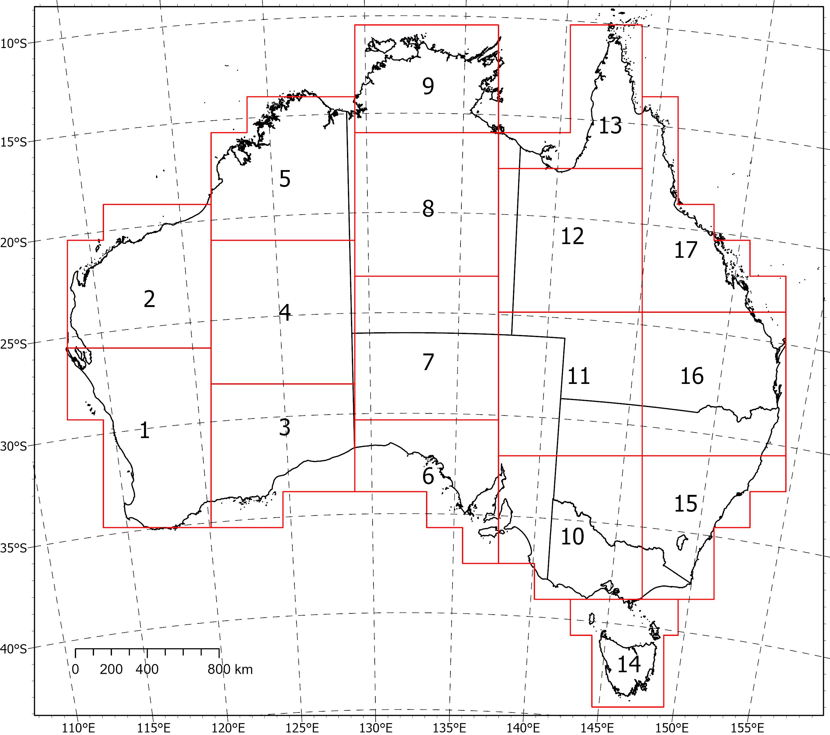
<div>Two coincident, crustal-scale models, one of magnetic susceptibility and one of density, have been produced for a volume covering the Australian continent and extending down to 55.5 km depth. These models were produced using the UBC‑GIF MAG3D and GRAV3D inversion programs, respectively.</div><div><br></div><div>The inversions were constrained with geological reference models with layers for sediments, undifferentiated crust and the mantle. The reference model for the magnetic inversion incorporated a Curie depth surface below which magnetic susceptibility was set to zero.</div><div><br></div><div>Due to the size of the inversion problem to be solved, the volume was divided into 235 overlapping inversions, which were inverted separately and then recombined. The method of recombining the inversions relies on a cosine function to determine the weight of each property and then takes a weighted average. This method successfully attenuated the edge effects that would otherwise occur between models and allows them to be viewed as one seamless model that covers the whole of Australia.</div><div><br></div><div>Regions of coincident high-density (>2.83 g/cm<sup>3</sup>) and high-magnetic susceptibility (>0.0125 SI) within the top 8‑9 km of the undifferentiated crust are suggested to be related to ultramafic rocks and the magnetite-forming hydrothermal alteration stages of potentially fertile IOCG systems. Currently the models are available in UBCGIF format (.den/.sus) only. Other formats and all supporting input data will be added in the near future. Due to their size, the models have been divided into subsets (labelled 1-17) for download. Please refer to the image below for the extent of the subsets.
-
NDI Carrara 1 is a deep stratigraphic drill hole completed in 2020 as part of the MinEx CRC National Drilling Initiative (NDI) in collaboration with Geoscience Australia and the Northern Territory Geological Survey. It is the first test of the Carrara Sub-Basin, a depocentre newly discovered in the South Nicholson region based on interpretation from seismic surveys (L210 in 2017 and L212 in 2019) recently acquired as part of the Exploring for the Future program. The drill hole intersected approximately 1100 m of Proterozoic sedimentary rocks uncomformably overlain by 630 m of Cambrian Georgina Basin carbonates. A comprehensive geochemical program designed to provide information about the region’s resource potential was carried out on samples collected at up to 4 meter intervals. This report presents data from magnetic susceptibility analyses undertaken by Geoscience Australia on selected rock samples to establish their ability to be magnetised in an applied external magnetic field.
