Resource geoscience
Type of resources
Keywords
Publication year
Topics
-
<div>The Woomera Prohibited Area coexistence framework, underpinned by the Woomera Prohibited Area Rule 2014, aims to balance the priorities of the Australian Defence Force with the priorities of non-defence users. in 2010, and again in 2018, the Australian Government undertook reviews of the Woomera Prohibited Area in order to assess the mineral and petroleum resources in the area. </div><div><br></div><div>The most recent report, <em>Woomera Prohibited Area Resource Prospectivity and Economic Assessment (October 2023)</em>, was commissioned by the South Australian Department for Energy and Mining and prepared by Scyne Advisory in order to provide a resource prospectivity analysis and an economic assessment based on modelled resource prospectivity. </div><div><br></div><div>This professional opinion is an evaluation of the validity of the minerals, energy and groundwater assessment methodology of the 2023 Scyne Advisory report. Access to this document must be sought from: • Branch Head, Mineral Systems Branch • Branch Head, Advice Investment Attraction and Analysis • Chief of Division, Minerals Energy and Groundwater </div>
-
<div>A PowerPoint presentation given by Chief of Minerals, Energy and Groundwater Division Dr Andrew Heap at NT Resources Week 2023. </div><div><br></div><div>This presentation had the theme of 'Precompetitive geoscience - Uncovering our critical minerals potential.'</div>
-
<div>The 2024 Critical Minerals in Ores (CMiO) Database factsheet contains information about the purpose of the CMiO, provides links to access the CMiO, two case studies on critical mineral abundance in deposits and a link to the user guide and submission template to provide data to the CMiO. This factsheet is an is an updated version of the Kelley 2020 USGS factsheet (https://doi.org/10.3133/fs20203035). The CMiO was produced through the Critical Minerals Mapping Initiative (CMMI), a collaboration between Geoscience Australia (GA), the Geological Survey of Canada (GSC) and the United States Geological Survey (USGS) in 2021 and is periodically updated. Note: A copy of the updated factsheet will not be available until the end of 2024.
-
<div>This study was commissioned by Geoscience Australia (GA) to produce a report on seal capacity of select samples from the deep stratigraphic hole NDI Carrara 1, located in the Proterozoic Carrara Sub-basin in the Northern Territory. Plugs were taken from depths of interest and analysed via mercury injection capillary pressure testing. Results were provided as two reports, Part A and Part B and demonstrate that the analysed samples are capable of sealing very large columns of both methane and carbon dioxide.</div>
-
<div>Two new programs at Geoscience Australia are providing trusted, high-quality science to support decision making and the Australian resources industry. </div><div> </div><div>The Trusted Environmental and Geological Information program will provide baseline pre-competitive data in the Cooper, Adavale, north Bowen and Galilee basin regions. A repository of information is being developed in collaboration with CSIRO, including new geological and environmental assessments, to accelerate development in the sectors of petroleum, mineral, hydrogen and carbon capture and storage, while simultaneously providing opportunities to understand the potential hazards, risk and impacts of these resources being developed. </div><div> </div><div>The Data Driven Discoveries program is combining new and old data to better understand the under-explored Adavale Basin in central-western Queensland. The program will undertake chemical composition analyses to support the correlation of geological layers, collate and reprocess historical seismic data, acquire new seismic reflection data, and undertake stratigraphic research drilling to provide a more detailed understanding of basin architecture and the resource potential of the Adavale Basin. </div><div> </div><div>An overview of the Trusted Environmental and Geological Information and Data Driven Discoveries programs will be provided, including initial results and planned acquisition. This will show how these complementary programs will contribute to streamlined regulation and approval processes, the low emissions agenda, and responsible resource development in key basin regions across Australia.</div> This Abstract was submitted/presented to the 2022 Petroleum Exploration Society of Australia (PESA) QLD Symposium 9 September (https://pesa.com.au/events/pesa-qld-2022-symposium/)
-
<div>The architecture of the lithosphere controls the distribution of thermal, compositional and rheological interfaces. It therefore plays a fundamental role in modulating key ore-forming processes including the generation, transport, fractionation, and contamination of melts. Recognition of its importance has led to renewed efforts in recent years to incorporate constraints on lithospheric structure into the targeting of prospective regions for mineral exploration. One example is a suggested relationship between the genesis of porphyry copper deposits – known to be associated with evolved, silica-rich magmas – and the thickness of the crust. Here, using a new compilation of spot measurements, we explore the utility of crustal thickness as an exploration tool for porphyry copper deposits.</div> This Abstract was submitted & presented at the 2022 American Geophysical Union (AGU) Fall Meeting 12-16 December (https://www.agu.org/Fall-Meeting-2022)
-
<div>A keynote talk talk given at Uncover Curnamona 2022 by Angela O'Rourke outlining the rationale, work program and new data acquisition for Geoscience Australia's Darling-Curnamona-Delamerian Project within Exploring for the Future</div> This presentation was given to the 2022 Uncover Curnamona 2022 Conference 31 May - 2 June:<br>(https://www.gsa.org.au/common/Uploaded%20files/Events/Uncover%20Curnamona%202021/UC2022_short_program_A4_web%20(003).pdf)
-
<div>In response to the acquisition of national-scale airborne electromagnetic surveys and the development of a national depth estimates database, a new workflow has been established to interpret airborne electromagnetic conductivity sections. This workflow allows for high quantities of high quality interpretation-specific metadata to be attributed to each interpretation line or point. The conductivity sections are interpreted in 2D space, and are registered in 3D space using code developed at Geoscience Australia. This code also verifies stratigraphic unit information against the national Australian Stratigraphic Units Database, and extracts interpretation geometry and geological data, such as depth estimates compiled in the Estimates of Geological and Geophysical Surfaces database. Interpretations made using this workflow are spatially consistent and contain large amounts of useful stratigraphic unit information. These interpretations are made freely-accessible as 1) text files and 3D objects through an electronic catalogue, 2) as point data through a point database accessible via a data portal, and 3) available for 3D visualisation and interrogation through a 3D data portal. These precompetitive data support the construction of national 3D geological architecture models, including cover and basement surface models, and resource prospectivity models. These models are in turn used to inform academia, industry and governments on decision-making, land use, environmental management, hazard mapping, and resource exploration.</div>
-
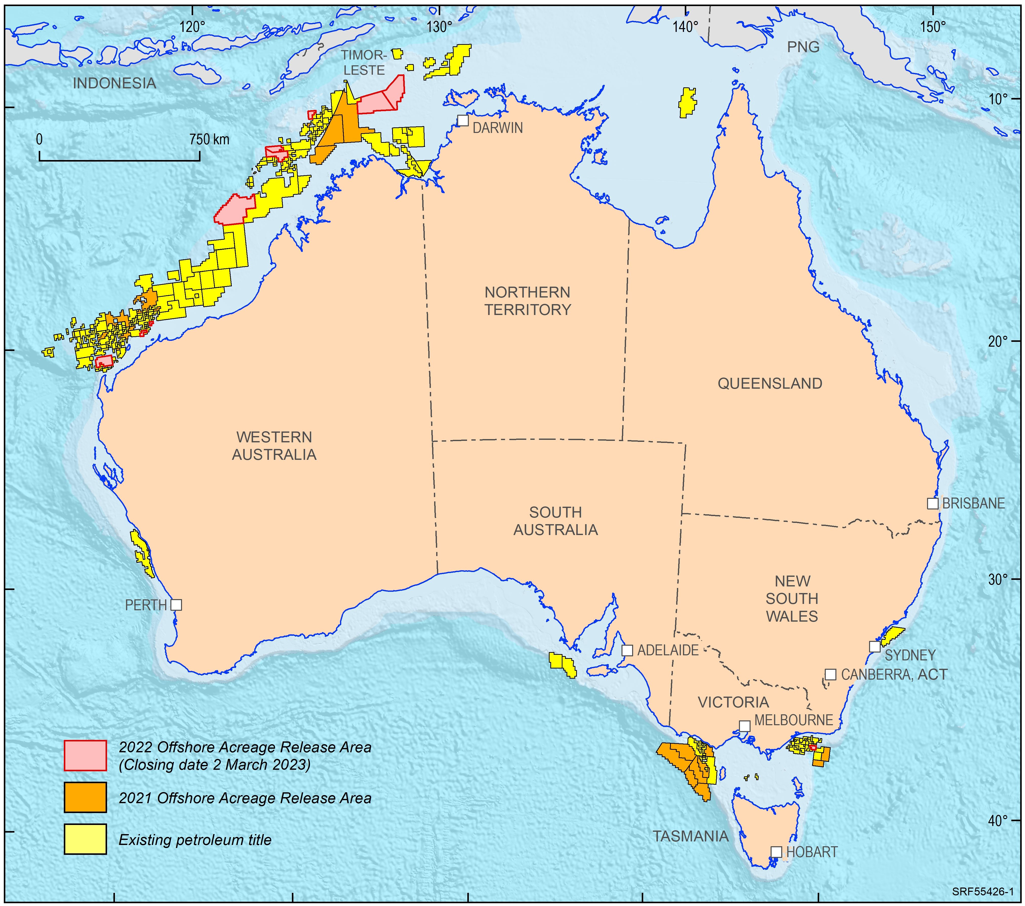
<div>In 2022, the Australian Government released ten offshore petroleum exploration areas. They are located in the Bonaparte Basin, Browse Basin, Northern Carnarvon Basin and Gippsland Basin. The areas highlight that producing provinces rather than data-poor regions are the preferred targets for exploration activities. In addition, the transition to low carbon energy resources, including opportunities for carbon capture and storage, has seen a diversification of energy companies’ portfolios. The Australian Government is supportive of the upstream energy industry, with natural gas seen as an important enabling energy resource commodity that supports the expansion of low emission technologies and related infrastructure. Most of the areas being offered for exploration in 2022 are likely to generate extra volumes of natural gas, both for domestic markets as well as securing feedstock for existing LNG export projects for the longer term. </div><div>Consistent with the approach of recent releases, only one period for work program bidding has been scheduled. The closing date for all bid submissions is 2 March 2023. </div><div>Geoscience Australia provides pre-competitive data and petroleum geological information in support of industry activities. Its petroleum geological studies aim to improve the understanding of the evolution of hydrocarbon-bearing basins at a regional scale and include a review of source rock and fluid occurrences, their geochemical characteristics, and petroleum systems modelling. Most recent examples include a sedimentological/stratigraphic study that investigates the depositional history of the southern Bonaparte Basin during the late Permian to Early Triassic evaluating the controls on reservoir facies development. A regional petroleum geological study of the Otway Basin, with a focus on the deeper water area and utilising newly industry acquired regional seismic data, provides new insights into the hydrocarbon prospectivity of this largely underexplored offshore part of the basin. Latest results of these studies were presented at this year’s APPEA conference. Large seismic and well data sets, submitted under the Offshore Petroleum and Greenhouse Gas Storage Act 2006 (OPGSSA) are made available through the National Offshore Petroleum Information Management System (NOPIMS). Additional data and petroleum related information can be accessed through Geoscience Australia’s data repository</div><div><br></div>
-
<div>Geoscience Australia’s Onshore Basin Inventories program provides a whole-of-basin inventory of geology, energy systems, exploration status and data coverage of onshore Australian basins. Volume 1 of the inventory covers the McArthur, South Nicholson, Georgina, Wiso, Amadeus, Warburton, Cooper and Galilee basins and Volume 2 expands this list to include the Officer, Perth and onshore Canning basins. These reports provide a single point of reference and create a standardised national inventory of onshore basins. In addition to summarising the current state of knowledge within each basin, the onshore basin inventory identifies critical science questions and key exploration uncertainties that may help inform future work program planning and aid in decision making for both government and industry organisations. Under Geoscience Australia’s Exploring for the Future (EFTF) program, six new onshore basin inventory reports will be delivered. </div><div> </div><div>These reports will be supported by selected value-add products that aim to address identified data gaps and evolve regional understanding of basin evolution and prospectivity. Petroleum system modelling is being undertaken in selected basins to highlight the hydrocarbon potential in underexplored provinces, and seismic reprocessing and regional geochemical studies are underway to increase the impact of existing datasets. The inventories are supported by the ongoing development of the nationwide source rock and fluids atlas, accessed through Geoscience Australia’s Exploring for the Future Data Discovery Portal, which continues to improve the veracity of petroleum system modelling in Australian onshore basins.</div><div> </div><div>In summarising avenues for further work, the Onshore Basin Inventories program has provided scientific and strategic direction for pre-competitive data acquisition under the EFTF work program. Here, we provide an overview of the current status of the Onshore Basin Inventories, with emphasis on its utility in shaping EFTF data acquisition and analysis, as well as new gap-filling data acquisition</div> This Abstract was submitted/presented at the 2023 Australasian Exploration Geoscience Conference (AEGC) 13-18 March (https://2023.aegc.com.au/)