Complete Bouguer Gravity Anomaly Colour Composite Image of Onshore Australia 2016
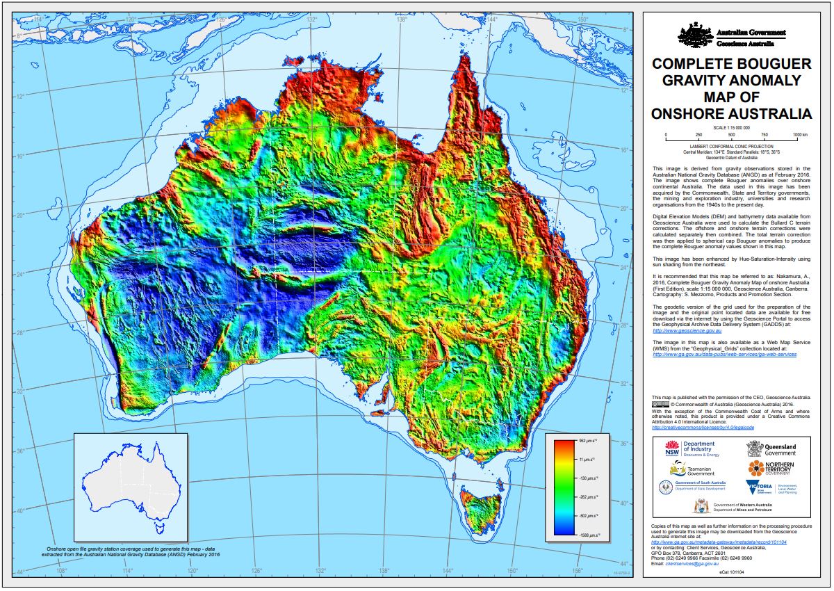
This gravity anomaly image has been derived from observations stored in the Australian National Gravity Database (ANGD) as at February 2016 as well as data from the 2013 New South Wales Riverina gravity survey. Out of the approximately 1.8 million gravity observations 1,371,998 gravity stations in the ANGD together with 19,558 stations from the Riverina survey were used to generate this image. The image shows complete Bouguer anomalies over onshore continental Australia. The data used in this image has been acquired by the Commonwealth, State and Territory Governments, the mining and exploration industry, universities and research organisations from the 1940's to the present day.
Terrain corrections to gravity were calculated using both offshore bathymetry and onshore topography data. These terrain corrections were applied to the spherical cap Bouguer anomalies used in the Bouguer Gravity Anomaly Grid of Onshore Australia 2016 to produce the complete Bouguer anomalies shown in this image.
The Complete Bouguer Gravity Anomaly Grid of Onshore Australia 2016 has been image enhanced and displayed as a hue-saturation-intensity (HSI) image with sun shading from the northeast to create this product.
Simple
Identification info
- Date (Creation)
- 2016-07-21T00:00:00
- Date (Publication)
- 2016-08-11T00:00:00
- Date (Revision)
- 2019-04-08T05:58:06
- Citation identifier
- Geoscience Australia Persistent Identifier/https://pid.geoscience.gov.au/dataset/ga/101104
- Cited responsible party
-
Role Organisation / Individual Name Details Custodian Geoscience Australia
Voice Author Nakamura, A.
Voice
- Status
- Point of contact
-
Role Organisation / Individual Name Details Owner Commonwealth of Australia (Geoscience Australia)
Voice Publisher Geoscience Australia
Voice Author Nakamura, A.
Voice
- Spatial representation type
- Topic category
-
- Geoscientific information
Extent
Temporal element
- Time period
- 1947-01-01 2015-12-31
Extent
))
- Maintenance and update frequency
- As needed
Resource format
- Title
-
Product data repository: Various Formats
- Protocol
-
FILE:DATA-DIRECTORY
- Name of the resource
-
Data Store directory containing the digital product files
- Description
-
Data Store directory containing one or more files, possibly in a variety of formats, accessible to Geoscience Australia staff only for internal purposes
- Function
- Offline access
- Theme
-
-
gravity
-
Bouguer
-
geophysics
-
National dataset
-
Gravity Digital Data
-
HSI
-
terrain correction
-
Complete Bouguer
-
- Australian and New Zealand Standard Research Classification: Fields of Research
-
-
Earth Sciences
-
- Keywords
-
-
Published_External
-
Resource constraints
- Title
-
Creative Commons Attribution 4.0 International Licence
- Alternate title
-
CC-BY
- Edition
-
4.0
- Access constraints
- License
- Use constraints
- License
Resource constraints
- Title
-
Australian Government Security ClassificationSystem
- Edition date
- 2018-11-01T00:00:00
- Classification
- Unclassified
- Language
- English
- Character encoding
- UTF8
Distribution Information
- Distributor contact
-
Role Organisation / Individual Name Details Distributor Commonwealth of Australia (Geoscience Australia)
Voice
- OnLine resource
-
Download the map (pdf – 41.8MB)
Download the map (pdf – 41.8MB)
- OnLine resource
-
Download the data (ecw geotiff - 103 MB)
Download the data (ecw geotiff - 103 MB)
Resource lineage
- Statement
-
This gravity anomaly image has been derived from observations stored in the Australian National Gravity Database (ANGD) as at February 2016 as well as data from the 2013 New South Wales Riverina gravity survey. The data used to produce this image was the Complete Bouguer Gravity Anomaly Grid of Onshore Australia 2016. The complete Bouguer grid has been image enhanced and displayed as a hue-saturation-intensity (HSI) image with sun shading from the northeast. Out of the approximately 1.8 million gravity observations 1,371,998 gravity stations in the ANGD together with 19,558 stations from the Riverina survey were used to generate this image. The image shows complete Bouguer anomalies over onshore continental Australia. The data used in this image has been acquired by the Commonwealth, State and Territory Governments, the mining and exploration industry, universities and research organisations from the 1940's to the present day.
Continental Australia has a base coverage of 11 kilometres, with South Australia, Tasmania and part of New South Wales covered with gravity stations at a spacing of 7 kilometres. Victoria has station coverage of approximately 1.5 kilometres. Federal, State and Territory Government initiatives have systematically infilled at a station spacing of 2 to 4 kilometres to improve coverage in areas of scientific or economic interest. Other areas of detailed coverage have been surveyed by private companies for exploration purposes. Only open file data held in the ANGD at February 2016 were used in the creation of the grid. The 2013 Riverina survey was added to the gridding process as this survey was not in the ANGD at the time.
The 2009 Bathymetry and Topography grid of Australia (Whiteway, 2009) and the 3 second Shuttle Radar Topography Mission (SRTM) Smoothed Digital Elevation Model (DEM-S) (Gallant et al., 2011) were used as the elevation models to calculate the Bullard C terrain corrections. These terrain corrections have been calculated using software from Intrepid Geophysics(1). The Intrepid algorithm utilises concentric rings subdivided into cells (Direen, 2001). The SRTM was used for the onshore terrain correction using five rings with a starting cell size of 90 metres resulting in a final radius of 92.2 kilometres. Four rings were used for the offshore terrain correction with a starting cell size of 250 m and a final radius of 64.0 km. The densities of materials used in the terrain corrections were 2670 kg/m^3 for land, 2200 kg/m^3 for marine sediments and 1027 kg/m^3 for sea water. The offshore and onshore terrain corrections were combined and applied to the spherical cap Bouguer anomalies used in the Bouguer Gravity Anomaly Grid of Onshore Australia 2016 to produce the complete Bouguer anomaly values shown in this image.
The Complete Bouguer Gravity Anomaly Grid of Onshore Australia 2016 has been image enhanced and displayed as a hue-saturation-intensity (HSI) image with sun shading from the northeast to create this product.
References:
1 http://www.intrepid-geophysics.com
Direen, N. G., 2001. Application of terrain corrections in Australia (2001). Geoscience Australia, Canberra. https://pid.geoscience.gov.au/dataset/ga/33808
Gallant, J.C., Wilson, N., Dowling, T.I., Read, A.M., and Inskeep, C., 2011. SRTM-derived 3 Second Digital Elevation Models Version 1.0. Geoscience Australia, Canberra. https://pid.geoscience.gov.au/dataset/ga/72760
Whiteway, T. G., 2009. Australian Bathymetry and Topograhy Grid, June 2009. Geoscience Australia, Canberra. http://dx.doi.org/10.4225/25/53D99B6581B9A
- Hierarchy level
- Dataset
Reference System Information
- Reference system identifier
-
EPSG/GDA94 (EPSG:4283)
- Title
-
European Petroleum Survey Group (EPSG) Geodetic Parameter Registry
- Date (Publication)
- 2008-11-12T00:00:00
- Cited responsible party
-
Role Organisation / Individual Name Details European Petroleum Survey Group
http://www.epsg-registry.org/
Reference System Information
- Reference system identifier
-
EPSG/GDA94 / Geoscience Australia Lambert (EPSG:3112)
- Title
-
European Petroleum Survey Group (EPSG) Geodetic Parameter Registry
- Date (Publication)
- 2008-11-12T00:00:00
- Cited responsible party
-
Role Organisation / Individual Name Details European Petroleum Survey Group
http://www.epsg-registry.org/
Metadata constraints
- Title
-
Australian Government Security ClassificationSystem
- Edition date
- 2018-11-01T00:00:00
- Classification
- Unclassified
Metadata
- Metadata identifier
-
urn:uuid/e3620bf4-bb01-4e5c-a14d-ae3f3c09f471
- Title
-
GeoNetwork UUID
- Language
- English
- Character encoding
- UTF8
- Contact
-
Role Organisation / Individual Name Details Point of contact Nakamura, A.
Commonwealth of Australia (Geoscience Australia)
Voice
Type of resource
- Resource scope
- Dataset
Alternative metadata reference
- Title
-
Geoscience Australia - short identifier for metadata record with
uuid
- Citation identifier
- eCatId/101104
- Date info (Creation)
- 2025-05-08T02:09:16.533Z
- Date info (Creation)
- 2016-07-18T16:53:57
- Date info (Revision)
- 2025-05-08T02:09:16.533Z
Metadata standard
- Title
-
AU/NZS ISO 19115-1:2014
Metadata standard
- Title
-
ISO 19115-1:2014
Metadata standard
- Title
-
ISO 19115-3
- Title
-
Geoscience Australia Community Metadata Profile of ISO 19115-1:2014
- Edition
-
Version 2.0, September 2018
- Citation identifier
- https://pid.geoscience.gov.au/dataset/ga/122551
Overviews
Spatial extent
Provided by
