Mapping the ocean floor
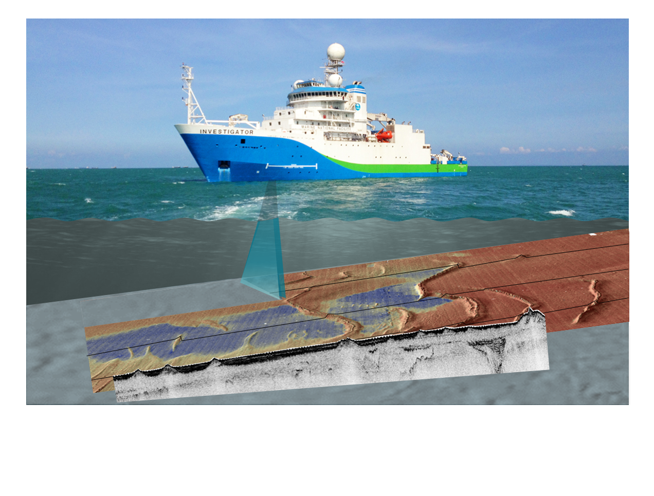
Have you ever wondered how we know the depth of the ocean? Sonar is the main technology used investigate the location of submarine canyons, seamounts, abyssal plains and if the seafloor is sand or rock. This activity builds understanding of sonar technique and applications through a) processing and plotting provided data to discover a seafloor feature or shipwreck, and b) bouncing balls on different surfaces and analysing rebound, relating this to ground hardness then extend understanding to ‘backscatter’ in bathymetry surveys. It is suitable for middle secondary students, but could be extended for senior students of Earth science, marine science/oceanography, and physics.
Simple
Identification info
- Date (Creation)
- 2020-08-14
- Date (Publication)
- 2020-08-14T02:06:05
- Citation identifier
- Geoscience Australia Persistent Identifier/https://pid.geoscience.gov.au/dataset/ga/144199
Identifier
- Codespace
-
Digital Obejct Identifier
- Purpose
-
Education
- Status
- Completed
- Point of contact
-
Role Organisation / Individual Name Details Point of contact Commonwealth of Australia (Geoscience Australia)
Voice Point of contact Iffland, D.
Office of the Chief Scts Internal Contact
- Spatial representation type
- Topic category
-
- Geoscientific information
Extent
))
- Maintenance and update frequency
- As needed
Resource format
- Title
-
Product data repository: Various Formats
- Protocol
-
FILE:DATA-DIRECTORY
- Name of the resource
-
Data Store directory containing the digital product files
- Description
-
Data Store directory containing one or more files, possibly in a variety of formats, accessible to Geoscience Australia staff only for internal purposes
- theme.ANZRC Fields of Research.rdf
-
-
Physical Oceanography
-
Acoustics and Acoustical Devices; Waves
-
OCEANOGRAPHY
-
EARTH SCIENCES
-
- Keywords
-
-
Published_External
-
Mapping
-
Educational Product
-
Resource constraints
- Title
-
Creative Commons Attribution 4.0 International Licence
- Alternate title
-
CC-BY
- Edition
-
4.0
- Addressee
-
Role Organisation / Individual Name Details User Any
- Use constraints
- License
- Use constraints
- Other restrictions
- Other constraints
-
© Commonwealth of Australia (Geoscience Australia) 2020
Resource constraints
- Title
-
Australian Government Security ClassificationSystem
- Edition date
- 2018-11-01T00:00:00
- Classification
- Unclassified
Associated resource
- Association Type
- null
- Title
-
Seafloor and land topography of Australia and surrounding region
- Citation identifier
- 68902
- Citation identifier
- a05f7892-eb31-7506-e044-00144fdd4fa6
- Language
- English
- Character encoding
- UTF8
Distribution Information
- Distributor contact
-
Role Organisation / Individual Name Details Distributor Commonwealth of Australia (Geoscience Australia)
Voice
- OnLine resource
-
Download the activity package (zip) [3 MB]
Download the activity package (zip) [3 MB]
- Distribution format
-
-
zip
-
Resource lineage
- Statement
-
Not supplied.
Metadata constraints
- Title
-
Australian Government Security Classification System
- Edition date
- 2018-11-01T00:00:00
- Classification
- Unclassified
Metadata
- Metadata identifier
-
urn:uuid/c5bfc6b3-565d-4e15-8a60-bf05cae264a9
- Title
-
GeoNetwork UUID
- Language
- English
- Character encoding
- UTF8
- Contact
-
Role Organisation / Individual Name Details Point of contact Commonwealth of Australia (Geoscience Australia)
Voice Point of contact Iffland, D.
Office of the Chief Scts Internal Contact
Type of resource
- Resource scope
- Document
- Name
-
Activity Package
Alternative metadata reference
- Title
-
Geoscience Australia - short identifier for metadata record with uuid
- Citation identifier
- eCatId/144199
- Date info (Creation)
- 2025-05-05T00:52:52.319Z
- Date info (Creation)
- 2025-04-17T00:51:44.313Z
- Date info (Creation)
- 2020-08-11T06:06:28
- Date info (Revision)
- 2025-05-05T00:54:36.545Z
Metadata standard
- Title
-
AU/NZS ISO 19115-1:2014
Metadata standard
- Title
-
ISO 19115-1:2014
Metadata standard
- Title
-
ISO 19115-3
- Title
-
Geoscience Australia Community Metadata Profile of ISO 19115-1:2014
- Edition
-
Version 2.0, September 2018
- Citation identifier
- https://pid.geoscience.gov.au/dataset/ga/144199
Overviews
Spatial extent
Provided by
