Surface Geology of Australia (1:1M scale dataset) A3 map
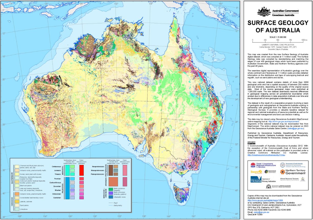
This map was created from the Surface Geology of Australia (1:1M scale) dataset, plotted at 1:15 million scale. The Surface Geology of Australia data was compiled by standardising and edge-matching over 400 geological maps which have been published by Australian Government, State and Territory agencies over the past 40 years. This seamless digital dataset is the most detailed national coverage available of the continent and islands. It provides information on the distribution and type of over 5000 outcropping bedrock and regolith units, such as sand plains and dunes.
Simple
Identification info
- Date (Publication)
- 2012-01-01T00:00:00
- Edition date
- 2012-01-01T00:00:00
- Citation identifier
- Geoscience Australia Persistent Identifier/https://pid.geoscience.gov.au/dataset/ga/73360
- Cited responsible party
-
Role Organisation / Individual Name Details Author Raymond, O.L.
1
- Point of contact
-
Role Organisation / Individual Name Details Custodian MNHD
Owner Commonwealth of Australia (Geoscience Australia)
Custodian Commonwealth of Australia (Geoscience Australia)
Voice
Spatial resolution
Equivalent scale
- Denominator
- 15000000
- Topic category
-
- Geoscientific information
Extent
))
- Maintenance and update frequency
- Unknown
Resource format
- Title
-
Product data repository: Various Formats
- Website
-
Data Store directory containing the digital product files
Data Store directory containing one or more files, possibly in a variety of formats, accessible to Geoscience Australia staff only for internal purposes
- Keywords
-
-
Geological Map
-
Non-standard scale
-
- Theme
-
-
geology
-
- Theme
-
-
mapping
-
- Australian and New Zealand Standard Research Classification (ANZSRC)
-
-
Geology
-
- Keywords
-
-
Published_External
-
Resource constraints
- Title
-
Creative Commons Attribution 4.0 International Licence
- Alternate title
-
CC-BY
- Edition
-
4.0
- Access constraints
- License
- Use constraints
- License
Resource constraints
- Title
-
Australian Government Security ClassificationSystem
- Edition date
- 2018-11-01T00:00:00
- Classification
- Unclassified
- Language
- English
- Character encoding
- UTF8
Distribution Information
- Distributor contact
-
Role Organisation / Individual Name Details Distributor Commonwealth of Australia (Geoscience Australia)
Voice
- OnLine resource
-
Download the map (pdf – 22.7MB)
Download the map (pdf – 22.7MB)
- Distribution format
-
-
pdf
-
- OnLine resource
-
Download the map (jpg – 3.18MB)
Download the map (jpg – 3.18MB)
- Distribution format
-
-
jpg
-
Resource lineage
- Statement
-
Unknown
- Hierarchy level
- Non geographic dataset
- Other
-
Geological Map
- Description
-
Source data not available.
Metadata constraints
- Title
-
Australian Government Security ClassificationSystem
- Edition date
- 2018-11-01T00:00:00
- Classification
- Unclassified
Metadata
- Metadata identifier
-
urn:uuid/b804b59b-3ceb-3a7e-e044-00144fdd4fa6
- Title
-
GeoNetwork UUID
- Language
- English
- Character encoding
- UTF8
- Contact
-
Role Organisation / Individual Name Details Point of contact Commonwealth of Australia (Geoscience Australia)
Voice
Type of resource
- Resource scope
- Document
- Name
-
GA Publication: Map
Alternative metadata reference
- Title
-
Geoscience Australia - short identifier for metadata record with
uuid
- Citation identifier
- eCatId/73360
- Date info (Revision)
- 2018-04-20T05:50:17
- Date info (Creation)
- 2012-02-03T00:00:00
Metadata standard
- Title
-
AU/NZS ISO 19115-1:2014
Metadata standard
- Title
-
ISO 19115-1:2014
Metadata standard
- Title
-
ISO 19115-3
- Title
-
Geoscience Australia Community Metadata Profile of ISO 19115-1:2014
- Edition
-
Version 2.0, September 2018
- Citation identifier
- https://pid.geoscience.gov.au/dataset/ga/122551
Overviews
Spatial extent
Provided by
