1:15M Australia General Reference Map (A3)
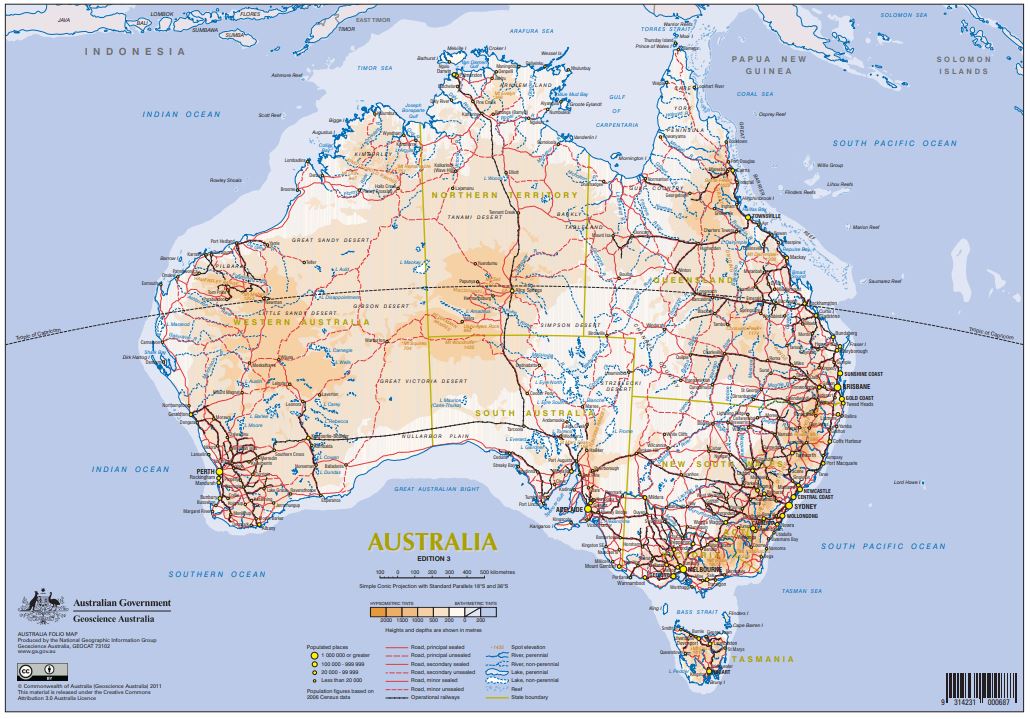
This map is a compact general reference map (A3 size, approximate 1:15 million scale) that has been designed for inclusion in publications requiring a simple, small size, multicoloured map of Australia. The map depicts a selection of the major geographic and cultural features that helps the user quickly familiarise themselves with the continent. This is a smaller scale version of the Australia 1:9 Million Compact General Reference Map, Edition 2.
Simple
Identification info
- Date (Publication)
- 2011-01-01T00:00:00
- Edition
-
3
- Edition date
- 2011-01-01T00:00:00
- Citation identifier
- Geoscience Australia Persistent Identifier/https://pid.geoscience.gov.au/dataset/ga/73102
- Cited responsible party
-
Role Organisation / Individual Name Details Author Geoscience Australia
1
- Point of contact
-
Role Organisation / Individual Name Details Custodian EGD
Owner Commonwealth of Australia (Geoscience Australia)
Custodian Commonwealth of Australia (Geoscience Australia)
Voice
Spatial resolution
Equivalent scale
- Denominator
- 15000000
- Topic category
-
- Imagery base maps earth cover
Extent
))
- Maintenance and update frequency
- Unknown
Resource format
- Title
-
Product data repository: Various Formats
- Website
-
Data Store directory containing the digital product files
Data Store directory containing one or more files, possibly in a variety of formats, accessible to Geoscience Australia staff only for internal purposes
- Keywords
-
-
Topographic Map
-
National
-
- Theme
-
-
topography
-
- Australian and New Zealand Standard Research Classification (ANZSRC)
-
-
Topology
-
- Keywords
-
-
Published_External
-
Resource constraints
- Title
-
Creative Commons Attribution 4.0 International Licence
- Alternate title
-
CC-BY
- Edition
-
4.0
- Access constraints
- License
- Use constraints
- License
Resource constraints
- Title
-
Australian Government Security ClassificationSystem
- Edition date
- 2018-11-01T00:00:00
- Classification
- Unclassified
- Language
- English
- Character encoding
- UTF8
Distribution Information
- Distributor contact
-
Role Organisation / Individual Name Details Distributor Commonwealth of Australia (Geoscience Australia)
Voice
- OnLine resource
-
Download the map (pdf – 1.27MB)
Download the map (pdf – 1.27MB)
- Distribution format
-
-
pdf
-
Resource lineage
- Statement
-
Unknown
- Hierarchy level
- Non geographic dataset
- Other
-
Topographic Map
- Description
-
Source data not available.
Metadata constraints
- Title
-
Australian Government Security ClassificationSystem
- Edition date
- 2018-11-01T00:00:00
- Classification
- Unclassified
Metadata
- Metadata identifier
-
urn:uuid/b2c0ff94-520e-02b9-e044-00144fdd4fa6
- Title
-
GeoNetwork UUID
- Language
- English
- Character encoding
- UTF8
- Contact
-
Role Organisation / Individual Name Details Point of contact Commonwealth of Australia (Geoscience Australia)
Voice
Type of resource
- Resource scope
- Document
- Name
-
GA publication: Map
Alternative metadata reference
- Title
-
Geoscience Australia - short identifier for metadata record with
uuid
- Citation identifier
- eCatId/73102
- Date info (Revision)
- 2018-04-22T08:21:26
- Date info (Creation)
- 2011-11-28T00:00:00
Metadata standard
- Title
-
AU/NZS ISO 19115-1:2014
Metadata standard
- Title
-
ISO 19115-1:2014
Metadata standard
- Title
-
ISO 19115-3
- Title
-
Geoscience Australia Community Metadata Profile of ISO 19115-1:2014
- Edition
-
Version 2.0, September 2018
- Citation identifier
- https://pid.geoscience.gov.au/dataset/ga/122551
Overviews
Spatial extent
Provided by
