Hydrogeology Map of Australia (G.Jacobson and JE.Lau Hydrogeology Map)
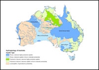
The principal aquifers of Australia (National Geoscience Dataset) has been used to produce the hydrogeology map of the Australian continent. It is described in terms of principal aquifers, defined as those producing the best quality water at highest yield from shallowest depth. Aquifers are defined as porous or fissured, and subdivided in terms of their extent and productivity; these aspects are shown in solid colour on the map.
Simple
Identification info
- Date (Creation)
- 1998-01-01T00:00:00
- Date (Publication)
- 2019-08-19T03:10:35
- Citation identifier
- Geoscience Australia Persistent Identifier/https://pid.geoscience.gov.au/dataset/ga/32368
- Cited responsible party
-
Role Organisation / Individual Name Details Author Brodie, R.S.
1 Author Kilgour, B.
2 Author Jacobson, G.
3 Author Lau, J.E.
4
- Point of contact
-
Role Organisation / Individual Name Details Owner Commonwealth of Australia (Geoscience Australia)
Custodian Commonwealth of Australia (Geoscience Australia)
Voice Point of contact Carey, H.
MEG Internal Contact
Spatial resolution
Equivalent scale
- Denominator
- 5000000
- Topic category
-
- Geoscientific information
Extent
))
- Maintenance and update frequency
- Not planned
Resource format
- Title
-
Product data repository: Various Formats
- Website
-
Data Store directory containing the digital product files
Data Store directory containing one or more files, possibly in a variety of formats, accessible to Geoscience Australia staff only for internal purposes
- Keywords
-
-
GIS Dataset
-
National
-
- Theme
-
-
hydrogeology
-
- Theme
-
-
GIS
-
- Theme
-
-
geology
-
- Theme
-
-
dataset
-
- Theme
-
-
marine
-
- Keywords
-
-
AU
-
- Australian and New Zealand Standard Research Classification (ANZSRC)
-
-
Earth Sciences
-
- Keywords
-
-
Published_External
-
Resource constraints
- Title
-
Creative Commons Attribution 4.0 International Licence
- Alternate title
-
CC-BY
- Edition
-
4.0
- Access constraints
- License
- Use constraints
- License
Resource constraints
- Title
-
Australian Government Security ClassificationSystem
- Edition date
- 2018-11-01T00:00:00
- Classification
- Unclassified
Associated resource
- Association Type
- Dependency
- Title
-
Hydrogeology of Australia MapServer
- Citation identifier
- 90108
- Citation identifier
- 2da7c234-63e9-10b2-e053-12a3070a174b
Associated resource
- Association Type
- Dependency
- Title
-
Hydrogeology of Australia WMS
- Citation identifier
- 90109
- Citation identifier
- 2da7c234-63ea-10b2-e053-12a3070a174b
- Language
- English
- Character encoding
- UTF8
Distribution Information
- Distributor contact
-
Role Organisation / Individual Name Details Distributor Commonwealth of Australia (Geoscience Australia)
Voice
- OnLine resource
-
Download the data (shp)
Download the data (shp)
- Distribution format
-
-
shp
-
Resource lineage
- Statement
-
Produced from the 1:5 000 000 scale Hydrogeology of Australia map (Jacobsen and Lau, 1987), involving conversion of IGDS files into Arcinfo and creating topology and attributing polygons. Later inclusion of AGSO standard attributes feature and UFI in 1998.
- Hierarchy level
- Dataset
- Description
-
Source data not available.
Reference System Information
- Reference system identifier
- EPSG/GDA94 (EPSG:4283)
Metadata constraints
- Title
-
Australian Government Security ClassificationSystem
- Edition date
- 2018-11-01T00:00:00
- Classification
- Unclassified
Metadata
- Metadata identifier
-
urn:uuid/a05f7892-8d5d-7506-e044-00144fdd4fa6
- Title
-
GeoNetwork UUID
- Language
- English
- Character encoding
- UTF8
- Contact
-
Role Organisation / Individual Name Details Point of contact Commonwealth of Australia (Geoscience Australia)
Voice
Type of resource
- Resource scope
- Dataset
- Name
-
dataset
Alternative metadata reference
- Title
-
Geoscience Australia - short identifier for metadata record with
uuid
- Citation identifier
- eCatId/32368
- Date info (Revision)
- 2018-04-11T03:12:21
- Date info (Creation)
- 2000-03-17T00:00:00
Metadata standard
- Title
-
AU/NZS ISO 19115-1:2014
Metadata standard
- Title
-
ISO 19115-1:2014
Metadata standard
- Title
-
ISO 19115-3
- Title
-
Geoscience Australia Community Metadata Profile of ISO 19115-1:2014
- Edition
-
Version 2.0, September 2018
- Citation identifier
- https://pid.geoscience.gov.au/dataset/ga/122551
Overviews
Spatial extent
Provided by
