Greater Shipwreck Trough (offshore Otway Basin): Surface Grids, Isochron Grids and Faults
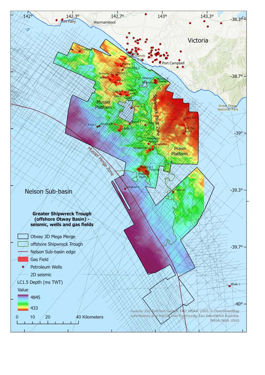
<p>This data package provides two-way time structure and isochron grids for horizons, together with fault sticks and fault network polygons, interpreted in the greater Shipwreck Trough area of the offshore Otway Basin. The data package is derived from seismic interpretation of the Otway Basin Mega Merge 3D seismic dataset, which was created by merging and reprocessing fifteen 3D surveys. The data package includes the following digital datasets: 1. Structure grids and point datasets measured in two-way time below sea-level, for six interpreted seismic horizons within the Otway Mega Merge 3D seismic cube; 2. Derived isochron grids for several of these horizons measured in two-way time; and 3. Interpreted fault sticks and fault network polygons. This work was undertaken as part of the Australian Government’s Resourcing Australia’s Prosperity initiative (RAPi) and is intended to be used to support the evaluation of the potential of geological storage of carbon dioxide in the offshore Otway Basin.</p>
Simple
Identification info
- Date (Creation)
- 2026-06-30
- Date (Publication)
- 2026-08-12T03:33:05.753Z
- Citation identifier
- Geoscience Australia Persistent Identifier/https://pid.geoscience.gov.au/dataset/ga/151129
Identifier
- Cited responsible party
-
Role Organisation / Individual Name Details Publisher Geoscience Australia
Author Bernardel, G.
External Contact Author Abbott, S.
External Contact Author Nicholson, C.
External Contact
- Purpose
-
The purpose of this product is to provide digital surface grids, isochron grids and fault maps for the greater Shipwreck Trough region (offshore Otway Basin) that government and industry can use for the assessment of underground storage of greenhouse gases in the Commonwealth jurisdiction.
- Status
- Completed
- Point of contact
-
Role Organisation / Individual Name Details Resource provider Minerals, Energy and Groundwater Division
External Contact Point of contact Commonwealth of Australia (Geoscience Australia)
Voice Point of contact Bernardel, G.
MEG Internal Contact
- Spatial representation type
- Topic category
-
- Geoscientific information
Extent
))
- Maintenance and update frequency
- As needed
Resource format
- Title
-
Product data repository: Various Formats
- Protocol
-
FILE:DATA-DIRECTORY
- Name of the resource
-
Data Store directory containing the digital product files
- Description
-
Data Store directory containing one or more files, possibly in a variety of formats, accessible to Geoscience Australia staff only for internal purposes
- Keywords
-
-
Shipwreck Trough
-
- Keywords
-
-
offshore Otway Basin
-
- Keywords
-
-
Carbon Capture and Underground Storage (CCUS)
-
- Keywords
-
-
Cretaceous
-
- Keywords
-
-
Waarre Formation
-
- Keywords
-
-
Belfast Mudstone
-
- Keywords
-
-
Otway 3D Mega Merge
-
- Keywords
-
-
Shipwreck Fault Zone
-
- Keywords
-
-
Prawn Platform
-
- Keywords
-
-
Mussel Platfrom
-
- Keywords
-
-
Mussel Hinge Zone
-
- Keywords
-
-
Flaxman Formation
-
- Keywords
-
-
Nelson Sub-basin
-
- Project
-
-
Resourcing Australia's Prosperity
-
Carbon Capture, Utilisation and Storage
-
- theme.ANZRC Fields of Research.rdf
-
-
EARTH SCIENCES
-
- Keywords
-
-
Published_External
-
Resource constraints
- Title
-
Creative Commons Attribution 4.0 International Licence
- Alternate title
-
CC-BY
- Edition
-
4.0
- Addressee
-
Role Organisation / Individual Name Details User Any
- Use constraints
- License
- Use constraints
- Other restrictions
- Other constraints
-
© Commonwealth of Australia (Geoscience Australia) 2026
Resource constraints
- Title
-
Australian Government Security Classification System
- Edition date
- 2018-11-01T00:00:00
- Classification
- Unclassified
- Classification system
-
Australian Government Security Classification System
Associated resource
- Association Type
- Was informed by
- Title
-
Surface Grids, Isochron Grids, and Fault Maps, Offshore Otway Basin (Updated September 2024)
- Citation identifier
- 146398
- Citation identifier
- f43f7c3f-d73b-45b3-8f08-db83621a9238
- Language
- English
- Character encoding
- UTF8
Distribution Information
- OnLine resource
-
Download metadata statement (pdf) [16.3 MB]
Download metadata statement (pdf) [16.3 MB]
- Distribution format
-
-
pdf
-
Distribution Information
- OnLine resource
-
Download data package (zip) [1.24 GB]
Download data package (zip) [1.24 GB]
- Distribution format
-
-
pdf
-
Distribution Information
- Distributor contact
-
Role Organisation / Individual Name Details Distributor Commonwealth of Australia (Geoscience Australia)
Voice
Resource lineage
- Statement
-
<p>This data is the result of detailed seismic interpretation within the Otway 3D Mega Merge seismic volume. All horizons, except for LC1.5, are derived from the regional interpretation work presented in the 2024 data package eCat #146398, and were tied to wells in Petrel software. Horizons were then exported from Petrel, imported to Petrosys where ASCII grid and float BIL surfaces and isochrons were generated. Faults were extracted from Petrel as points and Shapefiles.</p>
Reference System Information
Identifier
- Reference system type
- Projected
Metadata constraints
- Title
-
Australian Government Security Classification System
- Edition date
- 2018-11-01T00:00:00
- Classification
- Unclassified
Metadata
- Metadata identifier
-
urn:uuid/352f887e-38ff-4c7b-8715-a9b13221dda4
- Title
-
GeoNetwork UUID
- Language
- English
- Character encoding
- UTF8
- Contact
-
Role Organisation / Individual Name Details Point of contact Commonwealth of Australia (Geoscience Australia)
Voice Point of contact Bernardel, G.
Internal Contact Point of contact Bernardel, G.
Minerals, Energy and Groundwater Division Internal Contact
Type of resource
- Resource scope
- Dataset
- Name
-
Dataset
Alternative metadata reference
- Title
-
Geoscience Australia - short identifier for metadata record with uuid
- Citation identifier
- eCatId/151129
- Metadata linkage
-
https://ecat.ga.gov.au/geonetwork/srv/api/records/352f887e-38ff-4c7b-8715-a9b13221dda4
- Date info (Creation)
- 2026-09-01T23:15:51.903Z
- Date info (Creation)
- 2026-08-27T04:03:26.84Z
- Date info (Creation)
- 2026-08-17T01:50:16.882Z
- Date info (Creation)
- 2026-08-17T01:06:24.866Z
- Date info (Creation)
- 2026-08-17T00:02:43.983Z
- Date info (Creation)
- 2026-08-12T03:33:37.27Z
- Date info (Creation)
- 2026-05-18T01:23:53.845Z
- Date info (Revision)
- 2026-09-01T23:17:16.42Z
Metadata standard
- Title
-
AU/NZS ISO 19115-1:2014
Metadata standard
- Title
-
ISO 19115-1:2014
Metadata standard
- Title
-
ISO 19115-3
- Title
-
Geoscience Australia Community Metadata Profile of ISO 19115-1:2014
- Edition
-
Version 2.0, September 2018
- Citation identifier
- https://pid.geoscience.gov.au/dataset/ga/122551
Overviews
Spatial extent
Provided by
