Radiometric Map of Australia Edition 3 - A3 hardcopy version
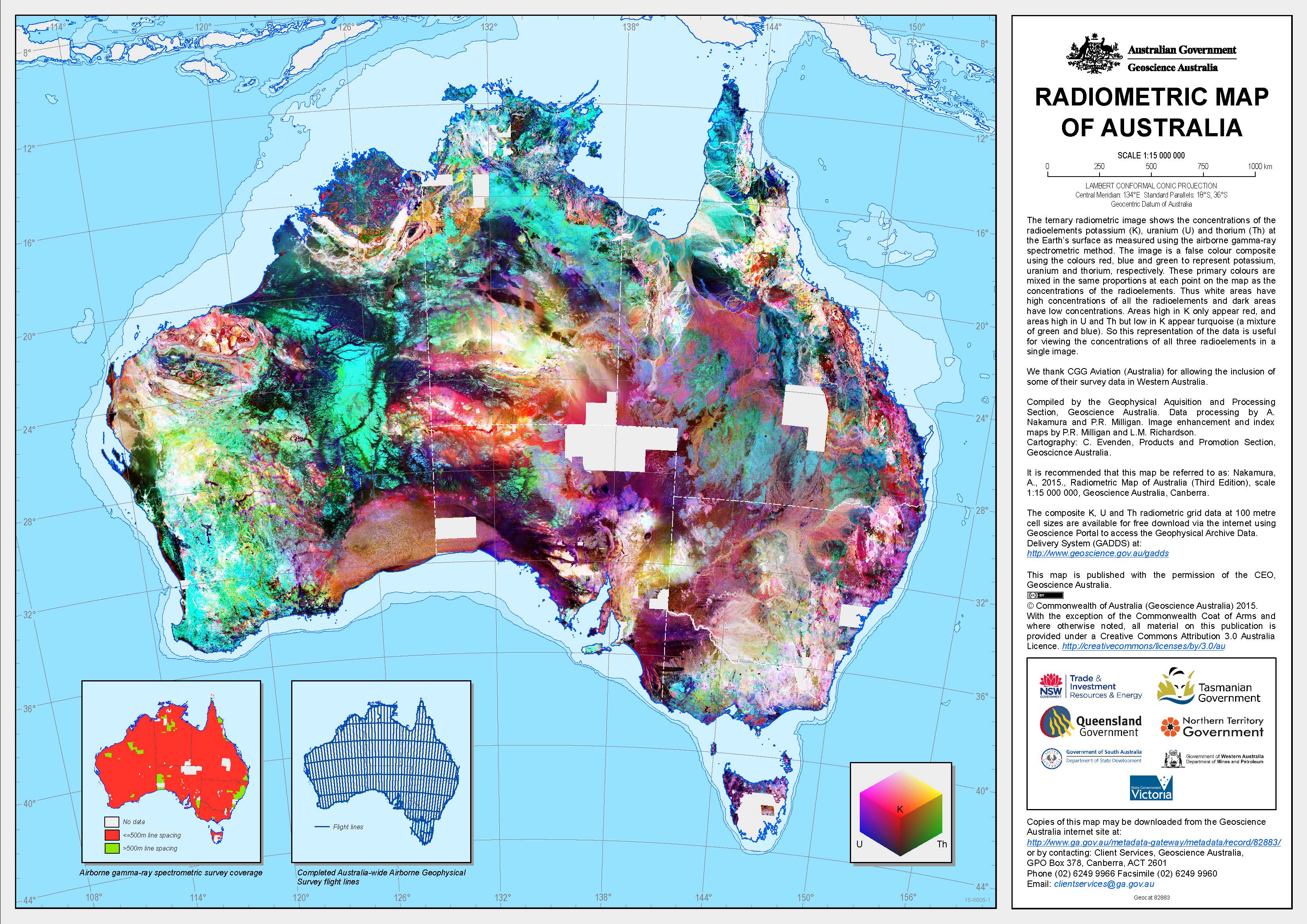
Geoscience Australia and State and Territory Geological Surveys have systematically surveyed most of the Australian continent over the past 40 years using airborne gamma-ray spectrometry to map potassium, uranium and thorium elemental concentrations at the Earth's surface. However, the individual surveys that comprise the national gamma-ray spectrometric radioelement database are not all registered to the same datum. This limits the usefulness of the database as it is not possible to easily combine surveys into regional compilations or make accurate comparisons between radiometric signatures in different survey areas.
To solve these problems, Geoscience Australia has undertaken an Australia-Wide Airborne Geophysical Survey (AWAGS), funded under Geoscience Australia's Onshore Energy Security Program, to serve as a radioelement baseline for all current and future airborne gamma-ray spectrometric surveys in Australia. The AWAGS survey has been back-calibrated to the International Atomic Energy Agency's (IAEA) radioelement datum. We have used the AWAGS data to level the national radioelement database by estimating survey correction factors that, once applied, minimize both the differences in radioelement estimates between surveys (where these surveys overlap) and the differences between the surveys and the AWAGS traverses. The database is thus effectively levelled to the IAEA datum. The levelled database has been used to produce the first 'Radiometric Map of Australia' - levelled and merged composite potassium (% K), uranium (ppm eU) and thorium (ppm eTh) grids over Australia at 100m resolution.
Interpreters can use the map to reliably compare the radiometric signatures observed over different parts of Australia. This enables the assessment of key mineralogical and geochemical properties of bedrock and regolith materials from different geological provinces and regions with contrasting landscape histories.
The Radiometric Map of Australia is available as a free PDF or JPG (2nd edition), and as an A0 printed wall map (1st edition) which can be purchased from the Geoscience Australia Sales Centre.
The gridded digital data which underpins the Radiometric Map of Australia is available free of charge for download using the Geophysical Archive Data Delivery System (GADDS). Because the grids are large (approximately 5.5 GB each), users planning to access entire grids at full resolution should contact <a href="mailto:minerals@ga.gov.au">minerals@ga.gov.au</a> to arrange alternative means of acquiring the digital data. minerals@ga.gov The gridded digital data which underpins the Radiometric Map of Australia is available free of charge for download using the Geophysical Archive Data Delivery System (GADDS). Because the grids are large (approximately 5.5 GB each), users planning to access entire grids at full resolution should contact <a href="mailto:minerals@ga.gov.au">minerals@ga.gov.au</a> to arrange alternative means of acquiring the digital data. >minerals@ga.gov The gridded digital data which underpins the Radiometric Map of Australia is available free of charge for download using the Geophysical Archive Data Delivery System (GADDS). Because the grids are large (approximately 5.5 GB each), users planning to access entire grids at full resolution should contact <a href="mailto:minerals@ga.gov.au">minerals@ga.gov.au</a> to arrange alternative means of acquiring the digital data.
Simple
Identification info
- Date (Publication)
- 2015-01-01T00:00:00
- Citation identifier
- Geoscience Australia Persistent Identifier/https://pid.geoscience.gov.au/dataset/ga/82883
- Cited responsible party
-
Role Organisation / Individual Name Details Author Nakamura, A.
1
- Point of contact
-
Role Organisation / Individual Name Details Custodian RD
Owner Commonwealth of Australia (Geoscience Australia)
Point of contact Commonwealth of Australia (Geoscience Australia)
Voice
Spatial resolution
Equivalent scale
- Denominator
- 15000000
- Topic category
-
- Geoscientific information
Extent
))
- Maintenance and update frequency
- Unknown
Resource format
- Title
-
Product data repository: Various Formats
- Website
-
Data Store directory containing the digital product files
Data Store directory containing one or more files, possibly in a variety of formats, accessible to Geoscience Australia staff only for internal purposes
- Keywords
-
-
Geophysical Map
-
gamma pixel
-
- Theme
-
-
gamma spectroscopy
-
- Theme
-
-
geophysics
-
- Keywords
-
-
AU
-
- Australian and New Zealand Standard Research Classification (ANZSRC)
-
-
Earth Sciences
-
- Keywords
-
-
Published_External
-
Resource constraints
- Title
-
Creative Commons Attribution 4.0 International Licence
- Alternate title
-
CC-BY
- Edition
-
4.0
- Access constraints
- License
- Use constraints
- License
Resource constraints
- Title
-
Australian Government Security ClassificationSystem
- Edition date
- 2018-11-01T00:00:00
- Classification
- Unclassified
- Language
- English
- Character encoding
- UTF8
Distribution Information
- Distributor contact
-
Role Organisation / Individual Name Details Distributor Commonwealth of Australia (Geoscience Australia)
Voice
- OnLine resource
-
Download Radiometric Map of Australia Edition 3 - A3 hardcopy version (pdf)
Download Radiometric Map of Australia Edition 3 - A3 hardcopy version (pdf)
- Distribution format
-
-
pdf
-
Resource lineage
- Statement
-
Unknown
- Hierarchy level
- Non geographic dataset
- Other
-
Geophysical Map
- Description
-
Source data not available.
Metadata constraints
- Title
-
Australian Government Security ClassificationSystem
- Edition date
- 2018-11-01T00:00:00
- Classification
- Unclassified
Metadata
- Metadata identifier
-
urn:uuid/0dd3e40c-0f92-927a-e053-12a3070aca0c
- Title
-
GeoNetwork UUID
- Language
- English
- Character encoding
- UTF8
- Contact
-
Role Organisation / Individual Name Details Point of contact Commonwealth of Australia (Geoscience Australia)
Voice
Type of resource
- Resource scope
- Document
- Name
-
GA Publication: Map
Alternative metadata reference
- Title
-
Geoscience Australia - short identifier for metadata record with
uuid
- Citation identifier
- eCatId/82883
- Date info (Revision)
- 2018-04-22T08:39:30
- Date info (Creation)
- 2015-01-30T00:00:00
Metadata standard
- Title
-
AU/NZS ISO 19115-1:2014
Metadata standard
- Title
-
ISO 19115-1:2014
Metadata standard
- Title
-
ISO 19115-3
- Title
-
Geoscience Australia Community Metadata Profile of ISO 19115-1:2014
- Edition
-
Version 2.0, September 2018
- Citation identifier
- https://pid.geoscience.gov.au/dataset/ga/122551
Overviews
Spatial extent
Provided by
