Total Magnetic Intensity (TMI) Colour Composite Image 2015
Total Magnetic Intensity colour composite image 2015
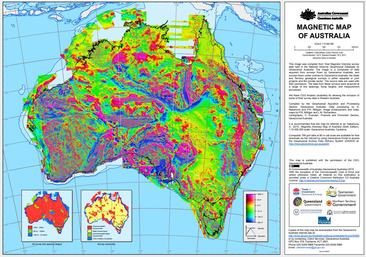
The image was created from the Total Magnetic Intensity Grid 2015 - sixth edition. This image has a cell size of ~3 seconds of arc (approximately 80 m) and has been image enhanced for optimal display in Hue-Saturation-Intensity (HSI).
This image only includes airborne-derived TMI data for onshore and near-offshore continental areas. Since the fifth edition was released in 2010 data from 41 new surveys have been added to the database, acquired mainly by the State and Territory Geological Surveys. It is estimated that
31 500 000 line-kilometres of survey data were acquired to produce the grid data, 4 500 000 line-kilometres more than for the previous edition.
Simple
Identification info
- Date (Publication)
- 2015-01-01T00:00:00
- Citation identifier
- Geoscience Australia Persistent Identifier/https://pid.geoscience.gov.au/dataset/ga/82799
- Citation identifier
- Digital Object Identifier/http://dx.doi.org/10.4225/25/561C7CE032EAB
- Cited responsible party
-
Role Organisation / Individual Name Details Publisher Geoscience Australia
Canberra Author Nakamura, A.
1 Author Milligan, P.R.
2
- Point of contact
-
Role Organisation / Individual Name Details Custodian RD
Owner Commonwealth of Australia (Geoscience Australia)
Custodian Commonwealth of Australia (Geoscience Australia)
Voice
- Topic category
-
- Geoscientific information
Extent
))
- Maintenance and update frequency
- As needed
Resource format
- Title
-
Product data repository: Various Formats
- Website
-
Data Store directory containing the digital product files
Data Store directory containing one or more files, possibly in a variety of formats, accessible to Geoscience Australia staff only for internal purposes
- Keywords
-
-
Airborne Digital Data
-
- Theme
-
-
TMI
-
- Theme
-
-
magnetics
-
- Theme
-
-
pixel images
-
- Theme
-
-
HSI
-
- Theme
-
-
NCI
-
- Keywords
-
-
AU
-
- Australian and New Zealand Standard Research Classification (ANZSRC)
-
-
Magnetism and Palaeomagnetism
-
- Theme
-
-
Geophysical National Coverage
-
- Keywords
-
-
Published_External
-
Resource constraints
- Title
-
Creative Commons Attribution 4.0 International Licence
- Alternate title
-
CC-BY
- Edition
-
4.0
- Access constraints
- License
- Use constraints
- License
Resource constraints
- Title
-
Australian Government Security ClassificationSystem
- Edition date
- 2018-11-01T00:00:00
- Classification
- Unclassified
- Language
- English
- Character encoding
- UTF8
Distribution Information
- Distributor contact
-
Role Organisation / Individual Name Details Distributor Commonwealth of Australia (Geoscience Australia)
Voice
- OnLine resource
-
Download Magnetic Map of Australia 6th Edition 2015 (pdf – 21.5MB)
Download Magnetic Map of Australia 6th Edition 2015 (pdf – 21.5MB)
- OnLine resource
-
Web Map Service
Link to Web Map Service
Resource lineage
- Statement
-
The image was created from the Total Magnetic Intensity Grid 2015 - sixth edition. This image has a cell size of ~3 seconds of arc (approximately 80 m) and has been image enhanced for optimal display as Hue-Saturation-Intensity (HSI).
The Total Magnetic Intensity grid is a composite TMI grid of the Australian region. This grid only includes airborne-derived TMI data for onshore and near-offshore continental areas.
Since the fifth edition was released in 2010 data from 41 new surveys have been added to the database, acquired mainly by the State and Territory Geological Surveys. It is estimated that
31 500 000 line-kilometres of survey data were acquired to produce the grid data, 4 500 000 line-kilometres more than for the previous edition.
Details of the specifications of individual airborne surveys can be found in the Fourteenth Edition of the Index of Airborne Geophysical Surveys (Percival, 2014). This Index is also available online at https://pid.geoscience.gov.au/dataset/ga/79134. Further up to date information about individual surveys can also be obtained online from the Airborne Surveys Database at http://www.ga.gov.au/oracle/argus/.
Matching of the grids in the database was achieved using a program called Gridmerge, which was originally developed within Geoscience Australia and has now been commercialised. This program was used to merge 41 new surveys to the 5th Edition Total Magnetic Intensity Anomaly Grid of Australia (Milligan et al., 2010). The 5th Edition merged 795 individual grids to create the compilation and to constrain long wavelengths, an independent data set, the Australia-wide Airborne Geophysical Survey (AWAGS) airborne magnetic data, was used to control the base levels of those survey grids which overlapped the AWAGS data (Milligan et al., 2009). As the 5th Edition was used as a base grid for the Gridmerge operation the new 6th Edition is essentially levelled to AWAGS.
References
Milligan, P.R., Minty, B.R.S., Richardson, M. & Franklin, R., 2009. The Australia-wide Airborne Geophysical Survey ¿ accurate continental magnetic coverage. Preview, 138, 70.
Milligan, P.R., Franklin, R., Minty, B.R.S., Richardson, L.M. and Percival, P.J., 2010. Magnetic Anomaly Map of Australia (Fifth Edition), 1:5 000 000 scale, Geoscience Australia, Canberra.
Percival, P.J., 2014. Index of airborne geophysical surveys (Fourteenth Edition). Geoscience Australia Record 2014/014.
- Hierarchy level
- Dataset
- Description
-
Source data not available.
Reference System Information
- Reference system identifier
-
EPSG/GDA94 (EPSG:4283)
- Title
-
European Petroleum Survey Group (EPSG) Geodetic Parameter Registry
- Date (Publication)
- 2008-11-12T00:00:00
- Cited responsible party
-
Role Organisation / Individual Name Details European Petroleum Survey Group
http://www.epsg-registry.org/
Metadata constraints
- Title
-
Australian Government Security ClassificationSystem
- Edition date
- 2018-11-01T00:00:00
- Classification
- Unclassified
Metadata
- Metadata identifier
-
urn:uuid/0d9a959a-f3f1-cb51-e053-12a3070ab5f9
- Title
-
GeoNetwork UUID
- Language
- English
- Character encoding
- UTF8
- Contact
-
Role Organisation / Individual Name Details Point of contact Commonwealth of Australia (Geoscience Australia)
Voice
Type of resource
- Resource scope
- Dataset
- Name
-
dataset
Alternative metadata reference
- Title
-
Geoscience Australia - short identifier for metadata record with
uuid
- Citation identifier
- eCatId/82799
- Date info (Revision)
- 2018-04-22T08:15:29
- Date info (Creation)
- 2015-01-27T00:00:00
Metadata standard
- Title
-
AU/NZS ISO 19115-1:2014
Metadata standard
- Title
-
ISO 19115-1:2014
Metadata standard
- Title
-
ISO 19115-3
- Title
-
Geoscience Australia Community Metadata Profile of ISO 19115-1:2014
- Edition
-
Version 2.0, September 2018
- Citation identifier
- https://pid.geoscience.gov.au/dataset/ga/122551
Overviews
Spatial extent
Provided by
