Product catalogue
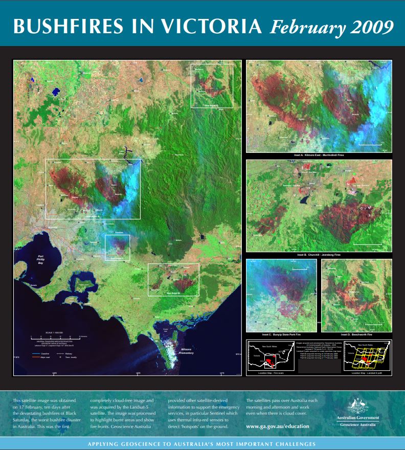
Bushfires in Victoria Feburary 2009 poster
The main part of this spliced satellite image was obtained on 17 February, ten days after the devastating bushfires of Black Saturday. This was the first cloud-acceptable image of the fires and was acquired by the Landsat-5 satellite.
Close-ups of Kilmore East-Murrindindi, CHurchill-Teeralang, Bunyip State Forest fire and Beecworth included.
The raw image was processed to highlight burnt areas (dark red) and show fire fronts. Vegetation appears green and the smoke appears pale blue.
Simple
Identification info
- Date (Publication)
- 2009-01-01T00:00:00
- Citation identifier
- Geoscience Australia Persistent Identifier/https://pid.geoscience.gov.au/dataset/ga/82344
- Cited responsible party
-
Role Organisation / Individual Name Details Publisher Geoscience Australia
Canberra Author Davis, L.I.
1
- Point of contact
-
Role Organisation / Individual Name Details Owner Commonwealth of Australia (Geoscience Australia)
Custodian Commonwealth of Australia (Geoscience Australia)
Voice Point of contact Iffland, D.
Office of the Chief Scts Internal Contact
- Topic category
-
- Geoscientific information
- Maintenance and update frequency
- Unknown
Resource format
- Title
-
Product data repository: Various Formats
- Protocol
-
FILE:DATA-DIRECTORY
- Name of the resource
-
Data Store directory containing the digital product files
- Description
-
Data Store directory containing one or more files, possibly in a variety of formats, accessible to Geoscience Australia staff only for internal purposes
- Keywords
-
-
Educational Product
-
- Australian and New Zealand Standard Research Classification (ANZSRC)
-
-
Earth Sciences
-
- Keywords
-
-
Published_External
-
Resource constraints
- Title
-
Creative Commons Attribution 4.0 International Licence
- Alternate title
-
CC-BY
- Edition
-
4.0
- Addressee
-
Role Organisation / Individual Name Details User Any
- Use constraints
- License
- Use constraints
- Other restrictions
- Other constraints
-
© Commonwealth of Australia (Geoscience Australia) 2009
Resource constraints
- Title
-
Australian Government Security ClassificationSystem
- Edition date
- 2018-11-01T00:00:00
- Classification
- Unclassified
- Language
- English
- Character encoding
- UTF8
Distribution Information
- Distributor contact
-
Role Organisation / Individual Name Details Distributor Commonwealth of Australia (Geoscience Australia)
Voice
- OnLine resource
-
Download poster high resolution (pdf – 244MB)
Download poster high resolution (pdf – 244MB)
- Distribution format
-
-
pdf
-
- OnLine resource
-
Download poster at low resolution (jpg – 3.25MB)
Download poster at low resolution (jpg – 3.25MB)
- Distribution format
-
-
jpg
-
- OnLine resource
-
Download poster low resolution (pdf – 1.67MB)
Download poster low resolution (pdf – 1.67MB)
- Distribution format
-
-
pdf
-
Resource lineage
- Statement
-
Unknown
- Hierarchy level
- Non geographic dataset
- Other
-
Educational Product
- Description
-
Source data not available.
Metadata constraints
- Title
-
Australian Government Security ClassificationSystem
- Edition date
- 2018-11-01T00:00:00
- Classification
- Unclassified
Metadata
- Metadata identifier
-
urn:uuid/05fc24f1-9276-47e8-e054-00144fdd4fa6
- Title
-
GeoNetwork UUID
- Language
- English
- Character encoding
- UTF8
- Contact
-
Role Organisation / Individual Name Details Point of contact Commonwealth of Australia (Geoscience Australia)
Voice
Type of resource
- Resource scope
- Document
- Name
-
GA publication: Poster
Alternative metadata reference
- Title
-
Geoscience Australia - short identifier for metadata record with uuid
- Citation identifier
- eCatId/82344
- Date info (Creation)
- 2025-05-08T01:39:17.608Z
- Date info (Revision)
- 2025-05-08T01:40:47.409Z
- Date info (Creation)
- 2014-10-22T00:00:00
Metadata standard
- Title
-
AU/NZS ISO 19115-1:2014
Metadata standard
- Title
-
ISO 19115-1:2014
Metadata standard
- Title
-
ISO 19115-3
- Title
-
Geoscience Australia Community Metadata Profile of ISO 19115-1:2014
- Edition
-
Version 2.0, September 2018
- Citation identifier
- https://pid.geoscience.gov.au/dataset/ga/122551