Product catalogue
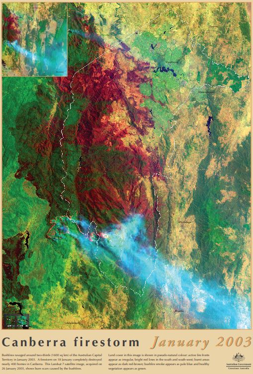
Canberra Firestorm poster
Bushfires ravaged around two-thirds of the Australian Capital Territory in January 2003. A firestorm on 18 January completely destroyed nearly 400 homes in Canberra. This Landsat 7 satellite image, acquired on 26 January 2003, shows burn scars caused by the bushfires.
Land cover in this image is shown in pseudo-natural colour: active fire fronts appear as irregular, bright red lines in the south and south-west; burnt areas appear as dark red-brown; bushfire smoke appears as pale blue and healthy vegetation appears as green.
Simple
Identification info
- Date (Creation)
- 2003-01-01
- Date (Publication)
- 2003-01-01T00:00:00+00:00
- Citation identifier
- Geoscience Australia Persistent Identifier/https://pid.geoscience.gov.au/dataset/ga/82343
- Cited responsible party
-
Role Organisation / Individual Name Details Publisher Geoscience Australia
Canberra Author Davis, L.I.
1
- Status
- Completed
- Point of contact
-
Role Organisation / Individual Name Details Custodian Corp
Owner Commonwealth of Australia (Geoscience Australia)
Custodian Commonwealth of Australia (Geoscience Australia)
Voice
- Topic category
-
- Geoscientific information
- Maintenance and update frequency
- Unknown
Resource format
- Title
-
Product data repository: Various Formats
- Protocol
-
FILE:DATA-DIRECTORY
- Name of the resource
-
Data Store directory containing the digital product files
- Description
-
Data Store directory containing one or more files, possibly in a variety of formats, accessible to Geoscience Australia staff only for internal purposes
- Keywords
-
-
Educational Product
-
- Australian and New Zealand Standard Research Classification (ANZSRC)
-
-
Earth Sciences
-
- Keywords
-
-
Published_External
-
Resource constraints
- Title
-
Creative Commons Attribution 4.0 International Licence
- Alternate title
-
CC-BY
- Edition
-
4.0
- Addressee
-
Role Organisation / Individual Name Details User Any
- Use constraints
- License
- Use constraints
- Other restrictions
- Other constraints
-
© Commonwealth of Australia (Geoscience Australia) 2003
Resource constraints
- Title
-
Australian Government Security ClassificationSystem
- Edition date
- 2018-11-01T00:00:00
- Classification
- Unclassified
- Language
- English
- Character encoding
- UTF8
Distribution Information
- Distributor contact
-
Role Organisation / Individual Name Details Distributor Commonwealth of Australia (Geoscience Australia)
Voice
- OnLine resource
-
Download the poster low resolution (pdf – 596kb)
Download the poster low resolution (pdf – 596kb)
- Distribution format
-
-
pdf
-
- OnLine resource
-
Download the poster low resolution (jpg – 1.95MB)
Download the poster low resolution (jpg – 1.95MB)
- Distribution format
-
-
jpg
-
- OnLine resource
-
Download the poster high resolution (pdf – 28.6MB)
Download the poster high resolution (pdf – 28.6MB)
- Distribution format
-
-
pdf
-
Resource lineage
- Statement
-
Unknown
- Hierarchy level
- Non geographic dataset
- Other
-
Educational Product
- Description
-
Source data not available.
Metadata constraints
- Title
-
Australian Government Security ClassificationSystem
- Edition date
- 2018-11-01T00:00:00
- Classification
- Unclassified
Metadata
- Metadata identifier
-
urn:uuid/05fc24f1-9275-47e8-e054-00144fdd4fa6
- Title
-
GeoNetwork UUID
- Language
- English
- Character encoding
- UTF8
- Contact
-
Role Organisation / Individual Name Details Point of contact Commonwealth of Australia (Geoscience Australia)
Voice
Type of resource
- Resource scope
- Document
- Name
-
GA publication: Poster
Alternative metadata reference
- Title
-
Geoscience Australia - short identifier for metadata record with uuid
- Citation identifier
- eCatId/82343
- Date info (Creation)
- 2025-05-08T01:53:45.938Z
- Date info (Revision)
- 2025-05-08T01:55:31.368Z
- Date info (Creation)
- 2014-10-22T00:00:00
Metadata standard
- Title
-
AU/NZS ISO 19115-1:2014
Metadata standard
- Title
-
ISO 19115-1:2014
Metadata standard
- Title
-
ISO 19115-3
- Title
-
Geoscience Australia Community Metadata Profile of ISO 19115-1:2014
- Edition
-
Version 2.0, September 2018
- Citation identifier
- https://pid.geoscience.gov.au/dataset/ga/122551