Australian Operating Mines Map 2012
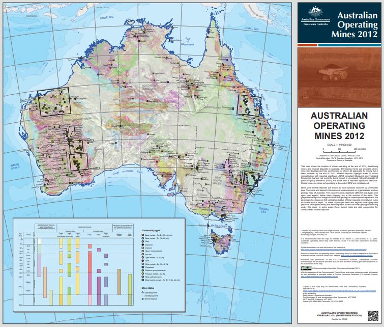
This map shows the locations of mines operating at the end of 2012, developing mines and mineral deposits in Australia. Developing mines are deposits with a proven minable resource and where mines site development has commenced or where a decision to mine has been announced. Mineral deposits highlight areas of know mineralisation with a proven or probable resource, that are not currently being mined or developed. Closed mines or mines not operating at the end of 2012 are not shown.
Simple
Identification info
- Date (Publication)
- 2013-01-01T00:00:00
- Edition
-
Jan 2013
- Citation identifier
- Geoscience Australia Persistent Identifier/https://pid.geoscience.gov.au/dataset/ga/75192
- Cited responsible party
-
Role Organisation / Individual Name Details Author Senior, A.B.
1 Author Skirrow, R.G.
2
- Point of contact
-
Role Organisation / Individual Name Details Custodian MNHD
Owner Commonwealth of Australia (Geoscience Australia)
Custodian Commonwealth of Australia (Geoscience Australia)
Voice
Spatial resolution
Equivalent scale
- Denominator
- 10000000
- Topic category
-
- Geoscientific information
Extent
))
- Maintenance and update frequency
- Unknown
Resource format
- Title
-
Product data repository: Various Formats
- Website
-
Data Store directory containing the digital product files
Data Store directory containing one or more files, possibly in a variety of formats, accessible to Geoscience Australia staff only for internal purposes
- Keywords
-
-
Thematic Map
-
- Australian and New Zealand Standard Research Classification (ANZSRC)
-
-
Earth Sciences
-
- Keywords
-
-
Published_External
-
Resource constraints
- Title
-
Creative Commons Attribution 4.0 International Licence
- Alternate title
-
CC-BY
- Edition
-
4.0
- Access constraints
- License
- Use constraints
- License
Resource constraints
- Title
-
Australian Government Security ClassificationSystem
- Edition date
- 2018-11-01T00:00:00
- Classification
- Unclassified
- Language
- English
- Character encoding
- UTF8
Distribution Information
- Distributor contact
-
Role Organisation / Individual Name Details Distributor Commonwealth of Australia (Geoscience Australia)
Voice
- OnLine resource
-
Download the file (pdf – 60.3MB)
Download the file (pdf – 60.3MB)
- Distribution format
-
-
pdf
-
- OnLine resource
-
Download the file (jpg – 6.96MB)
Download the file (jpg – 6.96MB)
- Distribution format
-
-
jpg
-
Resource lineage
- Statement
-
Unknown
- Hierarchy level
- Non geographic dataset
- Other
-
Thematic Map
- Description
-
Source data not available.
Metadata constraints
- Title
-
Australian Government Security ClassificationSystem
- Edition date
- 2018-11-01T00:00:00
- Classification
- Unclassified
Metadata
- Metadata identifier
-
urn:uuid/d3d4f1ce-4d66-5082-e044-00144fdd4fa6
- Title
-
GeoNetwork UUID
- Language
- English
- Character encoding
- UTF8
- Contact
-
Role Organisation / Individual Name Details Point of contact Commonwealth of Australia (Geoscience Australia)
Voice
Type of resource
- Resource scope
- Document
- Name
-
GA publication: Map
Alternative metadata reference
- Title
-
Geoscience Australia - short identifier for metadata record with
uuid
- Citation identifier
- eCatId/75192
- Date info (Revision)
- 2018-04-20T06:09:24
- Date info (Creation)
- 2013-01-22T00:00:00
Metadata standard
- Title
-
AU/NZS ISO 19115-1:2014
Metadata standard
- Title
-
ISO 19115-1:2014
Metadata standard
- Title
-
ISO 19115-3
- Title
-
Geoscience Australia Community Metadata Profile of ISO 19115-1:2014
- Edition
-
Version 2.0, September 2018
- Citation identifier
- https://pid.geoscience.gov.au/dataset/ga/122551
Overviews
Spatial extent
Provided by
