Australian Topographic Base Map MapServer
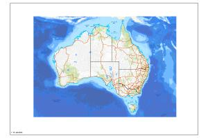
The Australian Topographic base map service is seamless national dataset coverage for the whole of Australia. The map is a representation of the Geoscience Australia 250k topographic specification and portrays a detailed graphic representation of features that appear on the Earth's surface. These features include cultural, hydrography and relief themes. The service contains layer scale dependencies.
Simple
Identification info
- Date (Creation)
- 2016-01-01T00:00:00
- Date (Publication)
- 2016-01-01T00:00:00
- Date (Revision)
- 2017-12-07T23:52:11
- Date (Revision)
- 2020-02-19T01:54:33
- Citation identifier
- Geoscience Australia Persistent Identifier/https://pid.geoscience.gov.au/service/ga/89993
- Cited responsible party
-
Role Organisation / Individual Name Details Publisher Geoscience Australia
Canberra
- Point of contact
-
Role Organisation / Individual Name Details Custodian Butrovski, D.
1 Point of contact Commonwealth of Australia (Geoscience Australia)
Voice
- Topic category
-
- Geoscientific information
Extent
))
- Maintenance and update frequency
- Annually
- Keywords
-
-
web service
-
- Theme
-
-
Australia
-
- Theme
-
-
Topography
-
- Theme
-
-
rail
-
- Theme
-
-
roads
-
- Theme
-
-
places
-
- Theme
-
-
Infrastructure
-
- Theme
-
-
Islands
-
- Theme
-
-
transport
-
- Theme
-
-
topographic
-
- Australian and New Zealand Standard Research Classification (ANZSRC)
-
-
Earth Sciences
-
- Service
-
-
MapServer
-
- Keywords
-
-
Published_External
-
Resource constraints
- Title
-
Creative Commons Attribution 4.0 International Licence
- Alternate title
-
CC-BY
- Edition
-
4.0
- Access constraints
- License
- Use constraints
- License
Resource constraints
- Title
-
Australian Government Security ClassificationSystem
- Edition date
- 2018-11-01T00:00:00
- Classification
- Unclassified
- Service Version
-
10.2
- Coupling Type
- Tight
Contains Operations
Contains Operations
- Operation Name
-
REST API Information
- Distributed computing platform (DCP)
- Web Services
- Name
-
f
- Type name
-
TEXT
- Parameter direction
-
- Description
-
The mandatory f parameter indicates the format of the response. When invoking the REST API Information operation the value json or pjson shall be used.
- Optionality
- true
- Repeatability
- false
Distribution Information
- Distributor contact
-
Role Organisation / Individual Name Details Distributor Geoscience Australia
Voice
- OnLine resource
-
Australian Topographic Base Map MapServer
Australian Topographic Base Map MapServer
- Distribution format
-
-
ESRI:ArcGIS:MapServer
-
Resource lineage
- Statement
-
The Australian Topographic service is constructed from 250K, 1 million and 5 million scale datasets used in mapping. This version of the service is due to an upgrade in Geoscience Australia infrastructure and as a result the service name and/or layer names may have changed.
- Hierarchy level
- Service
- Other
-
Web Service
- Description
-
Source data not available.
Reference System Information
- Reference system identifier
- EPSG/GDA94 (EPSG:4283)
Metadata constraints
- Title
-
Australian Government Security ClassificationSystem
- Edition date
- 2018-11-01T00:00:00
- Classification
- Unclassified
Metadata
- Metadata identifier
-
urn:uuid/2b4ce65a-48cb-dcb7-e053-12a3070a632e
- Title
-
GeoNetwork UUID
- Language
- English
- Character encoding
- UTF8
- Contact
-
Role Organisation / Individual Name Details Point of contact Commonwealth of Australia (Geoscience Australia)
Voice
Type of resource
- Resource scope
- Service
- Name
-
service
Alternative metadata reference
- Title
-
Geoscience Australia - short identifier for metadata record with
uuid
- Citation identifier
- eCatId/89993
- Date info (Revision)
- 2018-04-20T05:51:01
- Date info (Creation)
- 2016-02-09T00:00:00
Metadata standard
- Title
-
AU/NZS ISO 19115-1:2014
Metadata standard
- Title
-
ISO 19115-1:2014
Metadata standard
- Title
-
ISO 19115-3
- Title
-
Geoscience Australia Community Metadata Profile of ISO 19115-1:2014
- Edition
-
Version 2.0, September 2018
- Citation identifier
- https://pid.geoscience.gov.au/dataset/ga/122551
Overviews
Spatial extent
Provided by
