Topography of the Australian Continent - education poster
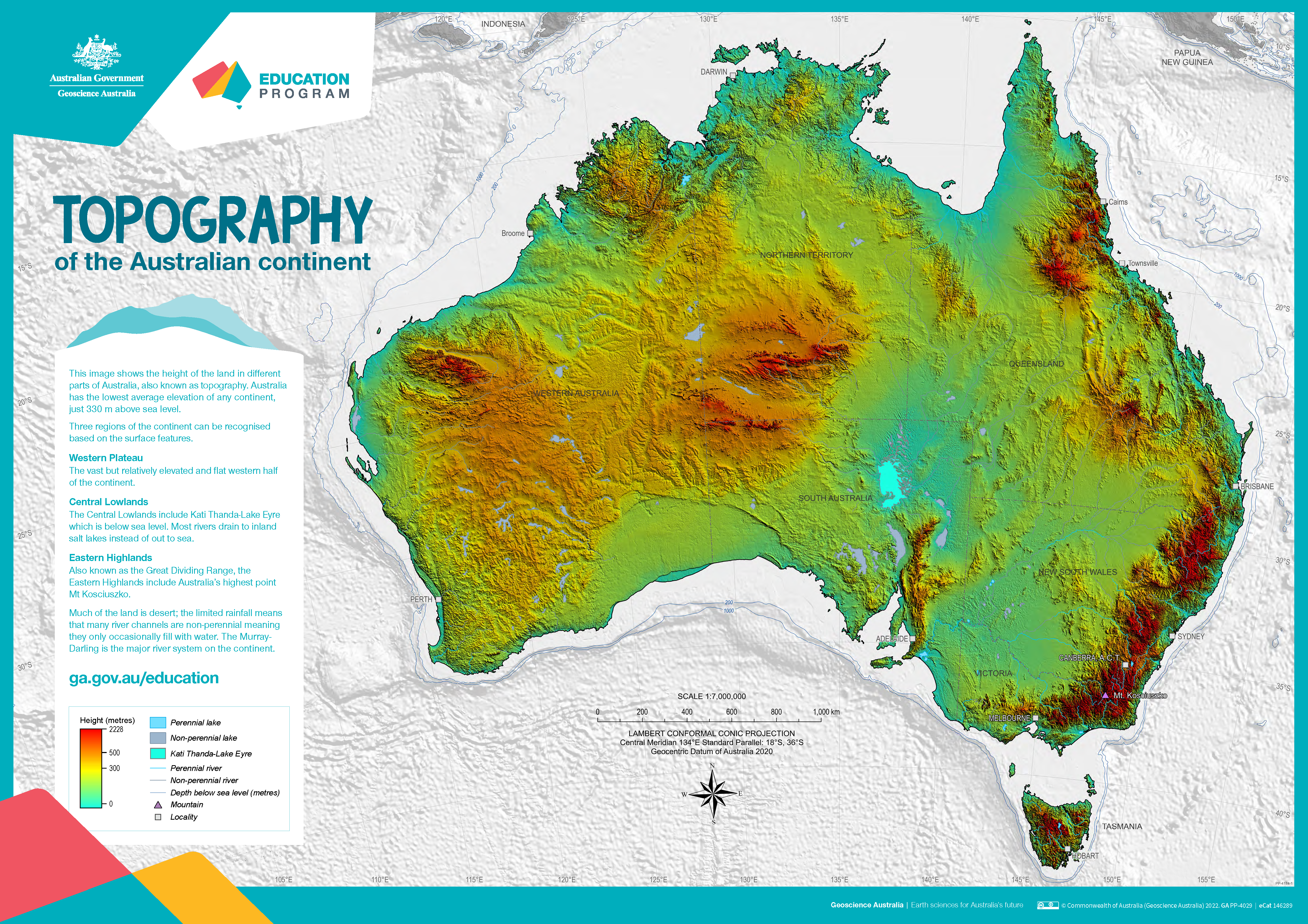
The poster uses a colourful digital elevation model to show the topography of the Australian continent. Low land is shown in green, higher land is yellow and orange and the highest parts of the country appear red. The map also shows perennial and non-perennial lakes and rivers as well as the location of the highest point in Australia and Kati Thanda-Lake Eyre at below sea level. The surrounding 200 m and 1000 m seabed depths contours are shown against a grey background. An accompanying text box outlines the three main physical regions of the county: the western plateau, central lowlands and eastern highlands. The poster is designed to be printed at A1 size which is 1:7 000 000 scale.
Simple
Identification info
- Date (Publication)
- 2022-04-29T06:56:41
- Date (Creation)
- 2022-04-29
- Citation identifier
- Geoscience Australia Persistent Identifier/https://pid.geoscience.gov.au/dataset/ga/146289
- Citation identifier
- Digital Object Identifier/https://dx.doi.org/10.26186/146289
- Cited responsible party
-
Role Organisation / Individual Name Details Author GA Education Program
External Contact Publisher Commonwealth of Australia (Geoscience Australia)
Voice
- Purpose
-
Resource for use with school age students to help with understanding of the shape of the surface of Australia and the way the continent may be divided into three regions.
- Status
- Completed
- Point of contact
-
Role Organisation / Individual Name Details Point of contact Commonwealth of Australia (Geoscience Australia)
Voice Point of contact Iffland, D.
Office of the Chief Scts Internal Contact Resource provider Office of the Chief Scientist
External Contact
- Spatial representation type
- Topic category
-
- Geoscientific information
Extent
Extent
))
- Maintenance and update frequency
- As needed
Resource format
- Title
-
Product data repository: Various Formats
- Protocol
-
FILE:DATA-DIRECTORY
- Name of the resource
-
Data Store directory containing the digital product files
- Description
-
Data Store directory containing one or more files, possibly in a variety of formats, accessible to Geoscience Australia staff only for internal purposes
- theme.ANZRC Fields of Research.rdf
-
-
EDUCATION
-
PHYSICAL GEOGRAPHY AND ENVIRONMENTAL GEOSCIENCE
-
- Theme
-
-
Topography
-
Map
-
- Keywords
-
-
Published_External
-
Resource constraints
- Title
-
Creative Commons Attribution 4.0 International Licence
- Alternate title
-
CC-BY
- Edition
-
4.0
- Addressee
-
Role Organisation / Individual Name Details User Any
- Use constraints
- License
- Use constraints
- Other restrictions
- Other constraints
-
© Commonwealth of Australia (Geoscience Australia) 2022
Resource constraints
- Title
-
Australian Government Security ClassificationSystem
- Edition date
- 2018-11-01T00:00:00
- Classification
- Unclassified
Associated resource
- Association Type
- Cross reference
- Title
-
Seafloor and land topography of Australia and surrounding region
- Citation identifier
- 68902
- Citation identifier
- a05f7892-eb31-7506-e044-00144fdd4fa6
- Language
- English
- Character encoding
- UTF8
Distribution Information
- Distributor contact
-
Role Organisation / Individual Name Details Distributor Commonwealth of Australia (Geoscience Australia)
Voice
- OnLine resource
-
Download the Poster (Hi-Res) (pdf) [22.2 MB]
Download the Poster (Hi-Res) (pdf) [22.2 MB]
- Distribution format
-
-
pdf
- File decompression technique
-
Nil
-
- OnLine resource
-
Download the Poster (Lo-Res) (pdf) [5.4 MB]
Download the Poster (Lo-Res) (pdf) [5.4 MB]
- Distribution format
-
-
pdf
- File decompression technique
-
Nil
-
Resource lineage
- Statement
-
Resource for use with school age students to help with understanding of the shape of the surface of Australia and the way the continent may be divided into three regions.
Metadata constraints
- Title
-
Australian Government Security Classification System
- Edition date
- 2018-11-01T00:00:00
- Classification
- Unclassified
Metadata
- Metadata identifier
-
urn:uuid/b7dc2470-8202-4cf1-b50d-d85ace330989
- Title
-
GeoNetwork UUID
- Language
- English
- Character encoding
- UTF8
- Contact
-
Role Organisation / Individual Name Details Point of contact Commonwealth of Australia (Geoscience Australia)
Voice Owner Blewett, S
Geoscience Australia Internal Contact Point of contact Iffland, D.
Office of the Chief Scts Internal Contact
Type of resource
- Resource scope
- Document
- Name
-
Teaching and Outreach Documents
Alternative metadata reference
- Title
-
Geoscience Australia - short identifier for metadata record with uuid
- Citation identifier
- eCatId/146289
- Date info (Creation)
- 2025-05-05T00:44:20.493Z
- Date info (Creation)
- 2025-04-17T02:49:32.399Z
- Date info (Creation)
- 2019-04-08T01:55:29
- Date info (Revision)
- 2025-05-05T00:45:25.37Z
Metadata standard
- Title
-
AU/NZS ISO 19115-1:2014
Metadata standard
- Title
-
ISO 19115-1:2014
Metadata standard
- Title
-
ISO 19115-3
- Title
-
Geoscience Australia Community Metadata Profile of ISO 19115-1:2014
- Edition
-
Version 2.0, September 2018
- Citation identifier
- https://pid.geoscience.gov.au/dataset/ga/122551
Overviews
Spatial extent
Provided by
