natural hazards
Type of resources
Keywords
Publication year
Service types
Topics
-
Knowledge of the nature of buildings within CBD areas is fundamental to a broad range of decision making processes, including planning, emergency management and the mitigation of the impact of natural hazards. To support these activities, Geoscience Australia has developed a building information system called the National Exposure Information System (NEXIS) which provides information on buildings across Australia. Most of the building level information in NEXIS is statistically derived, but efforts are being made to include more detailed information on the nature of individual buildings, particularly in CBD areas. This is being achieved in Hobart through field survey work.
-
Knowledge of the nature of buildings within CBD areas is fundamental to a broad range of decision making processes, including planning, emergency management and the mitigation of the impact of natural hazards. To support these activities, Geoscience Australia has developed a building information system called the National Exposure Information System (NEXIS) which provides information on buildings across Australia. Most of the building level information in NEXIS is statistically derived, but efforts are being made to include more detailed information on the nature of individual buildings, particularly in CBD areas. This is being achieved in Brisbane through field survey work.
-
Knowledge of the nature of buildings within business precincts is fundamental to a broad range of decision making processes, including planning, emergency management and the mitigation of the impact of natural hazards. To support these activities, Geoscience Australia has developed a building information system called the National Exposure Information System (NEXIS) which provides information on buildings across Australia. Most of the building level information in NEXIS is statistically derived, but efforts are being made to include more detailed information on the nature of individual buildings, particularly in business districts. This is being achieved in Adelaide through field survey work.
-
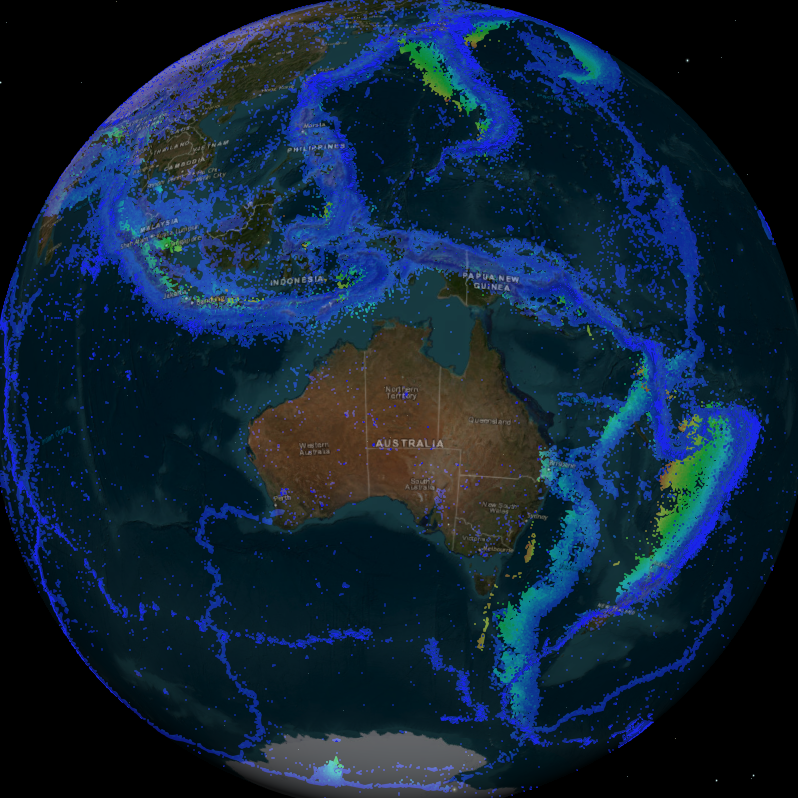
The service contains the 2013 Earthquake Hazard map, as a raster and contours. This map shows the peak ground acceleration (response spectral period of 0.01 seconds) on rock expected for a 500 year return period, in units of g, evaluated for the geometric mean of the horizontal components. The map is the closest in return period and response spectral period to the current earthquake hazard map in the Australian Standard AS1170.4-2007.
-
Knowledge of the nature of buildings within business precincts is fundamental to a broad range of decision making processes, including planning, emergency management and the mitigation of the impact of natural hazards. To support these activities, Geoscience Australia has developed a building information system called the National Exposure Information System (NEXIS) which provides information on buildings across Australia. Most of the building level information in NEXIS is statistically derived, but efforts are being made to include more detailed information on the nature of individual buildings, particularly in business districts. This is being achieved in Sydney through field survey work.
-
The service contains the 2013 Earthquake Hazard map, as a raster and contours. This map shows the peak ground acceleration (response spectral period of 0.01 seconds) on rock expected for a 500 year return period, in units of g, evaluated for the geometric mean of the horizontal components. The map is the closest in return period and response spectral period to the current earthquake hazard map in the Australian Standard AS1170.4-2007
-
Knowledge of the nature of buildings within business precincts is fundamental to a broad range of decision making processes, including planning, emergency management and the mitigation of the impact of natural hazards. To support these activities, Geoscience Australia has developed a building information system called the National Exposure Information System (NEXIS) which provides information on buildings across Australia. Most of the building level information in NEXIS is statistically derived, but efforts are being made to include more detailed information on the nature of individual buildings, particularly in business districts. This is being achieved in Adelaide through field survey work.
-
Knowledge of the nature of buildings within business precincts is fundamental to a broad range of decision making processes, including planning, emergency management and the mitigation of the impact of natural hazards. To support these activities, Geoscience Australia has developed a building information system called the National Exposure Information System (NEXIS) which provides information on buildings across Australia. Most of the building level information in NEXIS is statistically derived, but efforts are being made to include more detailed information on the nature of individual buildings, particularly in business districts. This is being achieved in Southbank through field survey work.
-
The service contains the 2013 Earthquake Hazard map, as a raster and contours. This map shows the peak ground acceleration (response spectral period of 0.01 seconds) on rock expected for a 500 year return period, in units of g, evaluated for the geometric mean of the horizontal components. The map is the closest in return period and response spectral period to the current earthquake hazard map in the Australian Standard AS1170.4-2007.
-
<div>Students can access and analyse real world earthquake data using online portals created by Geoscience Australia (GA) (Geoscience Australia data portal and Earthquakes@GA). The document provides background information for teachers about earthquakes and the online portals, as well as two student inquiry activities. Each activity includes instructions on how to access and use the relevant portal as well as questions that prompt students to find, record, and interpret the data. An Excel table is provided to accompany one of the activities.</div><div><br></div><div>The activities are suitable for use with secondary to senior secondary science and geography students. The topics covered in these activities include: earthquakes, plate tectonics and natural hazards.</div><div><br></div><div>The print version has lines provided for written answers, the accessible version is intended for digital responses. </div>